
Township 1, Rooks County, Kansas
Township 1 | |
|---|---|
 Location in Rooks County | |
| Coordinates: 39°26′17″N 99°06′03″W / 39.43806°N 99.10083°W | |
| Country | United States |
| State | Kansas |
| County | Rooks |
| Township 1 | 1971 |
| Elevation | 1,680 ft (512 m) |
| Population (2010) | |
| • Total | 242 |
| Time zone | UTC-6 (CST) |
| GNIS feature ID | 472247[1] |
Township 1 is a township in Rooks County, Kansas, United States. Woodston is the largest population center in Township 1.
History[edit]
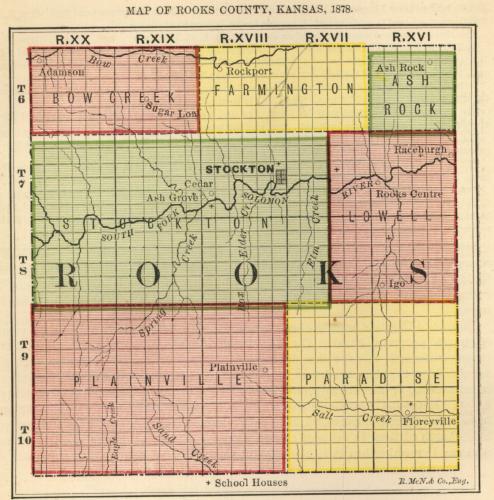
Rooks County was established with four townships: Bow Creek, Lowell, Paradise and Stockton. That number increased to seven by 1878[2] and twenty three in 1925. The twenty three townships were in place until 1971 when the number was reduced to the current twelve townships.[3]
Township 1 was formed from Rooks County townships Ash Rock, Lowell and Medicine[4] in 1971 pursuant to Kansas Statute 80-1110.[5] 80-1110 allowed for the disorganization of townships and assigning those territories to contiguous townships.[6]
Buros Creek flows through the northern part of Township 1 into South Fork Solomon River. Medicine Creek flows through the southern part of Township 1 into South Fork Solomon River.
Ash Rock Township[edit]
Ash Rock Township was established in 1877 from part of Lowell Township. The township was named for a petrified tree trunk found by an early settler, H. C. Olds. The Stone Church built in 1883 is a landmark from Ash Rock township.[7]
Lowell Township[edit]
Lowell Township was one of the four original Rooks County civil townships along with Bow Creek, Paradise and Stockton. The original Lowell Township was 18 miles north-to-south (3 survey townships). The west border was with Bow Creek and Stockton Townships. The east border the Osborne County line making it 9 miles (1-1/2 survey townships) wide. Lowell originally included territory that would become Ash Rock, Medicine and parts of Greenfield, Iowa and Lanark townships.[2]
The South Fork Solomon River traversed Lowell Township.[8]
Medicine Township[edit]
Medicine Township was established in 1879 from part of Lowell Township. The township was named for Medicine Creek that traversed the township to the South Fork Solomon River. Medicine Creek was called "heap big medicine" by Native Americans.[9]
References[edit]
- ^ "US Board on Geographic Names". United States Geological Survey. October 13, 1978. Retrieved January 7, 2018.
- ^ a b "MAP OF ROOKS COUNTY, KANSAS, 1878". KS Gen Web. Retrieved February 10, 2018.
- ^ "Rooks County Kansas". Kansas Historical Society. Retrieved February 10, 2018.
- ^ "Kansas Civil Townships and Independent Cities". Kansas Historical Society. Retrieved January 7, 2018.
- ^ BOARD OF COUNTY COMMISSIONERS, ROOKS COUNTY KANSAS (January 7, 1971). "LEGAL ADVERTISING". Plainville Times. p. 10.
- ^ "Chapter 80.:-TOWNSHIPS AND TOWNSHIP OFFICERS". Kansas Office of Revisor of Statutes. Retrieved February 10, 2018.
- ^ Dodrill, Mrs. Ellsworth (January 26, 1961). "A History of Ash Rock Township". Plainville Times. p. 8.
- ^ Murphy, Elton J. (March 2, 1961). "A History of Lowell Township". Plainville Times. p. 5.
- ^ Rubottom, Mrs. L. A. (March 23, 1961). "A History of Medicine Township". Plainville Times. p. 5.
Municipalities and communities of Rooks County, Kansas, United States | ||
|---|---|---|
| Cities | 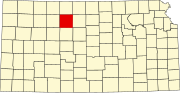 | |
| Unincorporated communities | ||
| Ghost towns | ||
| Townships | ||
| Footnotes | †This community is designated a Census-Designated Place (CDP) by the United States Census Bureau. | |
This article about a location in Rooks County, Kansas is a stub. You can help Wikipedia by expanding it. |