User:Arielco/Magnetic declination

Magnetic declination (also called magnetic variation) is the difference between the direction of the horizontal component of the Earth's magnetic field in a given place and true north. Thus, it is the angular error incurred when determining north with a compass.
Causes[edit]

Earth's magnetic field is due to and influenced by various phenomena both above and below the planet's surface. The main part of this field is sustained in the outer core by a naturally occurring dynamo. In the mantle, currents can be induced by time-dependent variations in the ambient magnetic field. In the crust the field has both induced and permanent components. And, in the ionosphere and magnetosphere electric currents are sustained through a complicated interaction with the Sun, the heliomagnetic field, and the solar wind of charged particles.[1]. In some places, deposits of iron ore in the Earth's crust may shape the field strongly. Also, magnetic poles do not coincide with the geographical poles as defined by the Earth's axis of rotation. As a result, the field lines are far from those of a simple, symmetric dipole and will seldom run along the direction of the true north/south poles at a given location. For example, as a traveller cruises the east coast of the United States, the direction of the magnetic field may vary from 20 degrees west of true north in Maine, to true north in Florida, to 10 degrees east in Texas, meaning a compass would have to be adjusted several times along the trip to account for the changing declination.
Notation[edit]
The direction of the local magnetic field relative to true north in a given location is usually expressed as an angle in degrees, plus an indication of the sense such as East/West or a +/- sign (respectively). Alternatively, the clockwise bearing in mils may be given, from 0 mils (no declination) up to 6399 mils. Thus, "10°W", "-10°" and "6220 mils" all indicate that a compass needle placed in this location will point 10 degrees west of true north.
- On maps that cover an area small enough that declination can be assumed to be constant, (e.g. the topographic maps of the U.S. Geological Survey), a diagram shows local magnetic declination as an angle formed by two arrows or lines that represent magnetic north and true north, plus a label stating the declination in degrees as above. Magnetic north may be drawn with a half-head and true north may have a five-pointed star at its top. Some maps specify the year in which the indicated declination was measured and the predicted rate of change in minutes of arc per year (see below).
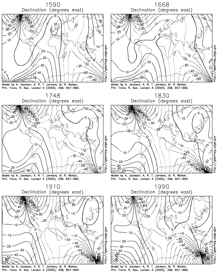
- Larger aeronautical and nautical charts feature isogonic lines or "isogons", which are contour lines of equal declination. Isogons with zero declination are called agonic lines. The rate of change can also be shown with contour lines.
Secular variation[edit]

Magnetic declination also varies with the passage of time. The same convective motion that drives the geodynamo deep inside the Earth also causes the field at the surface to be time-dependent over historical timescales, a phenomenon known as 'secular variation'. In fact, magnetic models and charts must be periodically updated to accommodate the continual secular variation of the field.[2]. This drift may be positive (eastward), zero or negative, and the rate of change may reach 1.5 degrees per year in the proximity of the north pole [3]. Even where the variation is of a few minutes of arc per year, it may be of particular significance when using magnetic bearings from old documents such as land surveys. Online calculators are also available, which use the International Geomagnetic Reference Field Model to estimate the declination for a given location and date.[4]
Measuring declination[edit]
Declination can be measured on site by comparing the direction of a compass needle to a geographical reference such as the celestial poles (the center of the apparent circular motion of the stars traversing the night sky). In the northern hemisphere, Polaris (the North Star) can be used as a reference; it currently traces a circle 0.75° in radius around the north celestial pole so this will be the accuracy of the measurement. At high latitudes a plumb-bob is helpful to project the position of Polaris closer to the horizon and then take its bearing.[5]
Using the declination[edit]
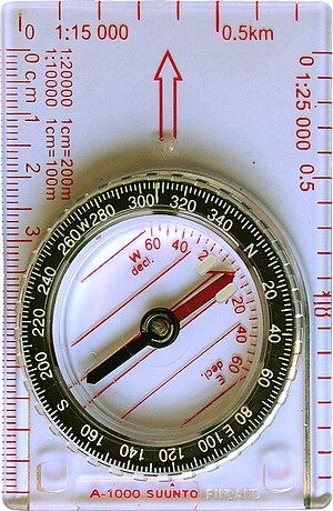
To compensate for declination when using a compass,
Adjustable compasses[edit]

Modern navigational compasses may be mounted on a "base plate" with a graduated scale in degrees/mils around which it can be rotated, or alternatively a second .
Non-adjustable compasses[edit]

With a compass lacking an adjustable baseplate, a careful, well-practiced, compass user can analyse the combination of declination and task, and decide whether the declination is to be added or subtracted from the known direction to determine an unknown direction.
In a place where the declination needs to be subtracted from an angle measured on a map from true north to a destination, to learn the compass reading to follow (on an unadjusted compass) to walk that course, the declination needs to be added to the compass reading that a landmark lies along, to learn the direction on the map to seek the name to match the landmark with.
[edit]
In navigation the terminology of geomagnetism is used differently. In particular, magnetic declination is divided into two parts, namely magnetic variation and magnetic deviation. There are also three types of bearings—true, magnetic, and compass—which are related by the rules:
A simple way of remembering which way to apply the correction is as follows: (in the Continental USA) For locations east of the agonic line (zero declination), roughly east of the Mississippi: The magnetic bearing is always bigger. For locations west of the agonic line (zero declination), roughly west of the Mississippi: The magnetic bearing is always smaller.
[edit]
Magnetic declination has a very important influence on air navigation, since the most simple aircraft navigation instruments are designed to determine headings by locating magnetic north through the use of a compass or similar magnetic device.
Aviation sectionals (maps / charts) and databases used for air navigation are based on True north rather than magnetic north, and the constant and significant slight changes in the actual location of magnetic north and local irregularities in the planet's magnetic field require that charts and databases be updated at least 2 times per year to reflect the current magnetic variation correction from True north. For example, near San Francisco, magnetic north is about 14.3 degrees east of True north, but the difference is decreasing by about 6 minutes of arc per year.
When plotting a course, a pilot in most small planes will plot a trip using true north on a sectional (map), then, convert the true north bearings to magnetic north for in-plane navigation use (which rely on cockpit instruments that read magnetic north).
Radionavigation aids located on the ground, such as VORs, are also checked and updated to keep them aligned with magnetic north to allow pilots to use their magnetic compasses for accurate and reliable in-plane navigation
GPS systems used for air navigation can use magnetic north or true north. In order to make them more compatible with systems that depend on magnetic north, magnetic north is often chosen, at the pilot's preference. The GPS receiver natively reads in true north, but can elegantly calculate magnetic north based on its true position and data tables calculate the current location and direction of the north magnetic pole and (potentially) any local variations, if the GPS is set to use magnetic compass readings.
See also[edit]

References[edit]
- ^ "USGS National Geomagnetism Program: Program Summary". Retrieved 8 March 2010.
- ^ "USGS National Geomagnetism Program: Intro to Geomagnetism". Retrieved 8 March 2010.
- ^ Kenneth S. Rukstales, John M. Quinn (USGS). "The International Geomagnetic Reference Field, 2000" (PDF). Retrieved 8 March 2010.
- ^ http://www.ngdc.noaa.gov/geomagmodels/Declination.jsp.
{{cite web}}: Missing or empty|title=(help); Unknown parameter|Title=ignored (|title=suggested) (help) - ^ Magnetic declination, what it is, how to compensate.
External links[edit]
- USGS Geomagnetism Program
- Magnetic declination maps.
- Online declination calculator at the National Geophysical Data Center (NGDC)
- Online declination calculator with Google Maps
- Online declination and field strength calculator at the NGDC
- Magnetic declination calculator at Natural Resources Canada
Category:Navigation
Category:Geomagnetism
Category:Angle


