User:CareAhLine/sandbox
 | |
 | |
| Location | Bonaire, Kralendijk, Bonaire, Kralendijk, Netherlands |
|---|---|
| Coordinates | 12°08′56″N 68°16′37″W / 12.14881°N 68.27681°W |
| Tower | |
| Constructed | 1837 (first)[1] |
| Construction | stone tower[1] |
| Height | 7 metres (23 ft)[2] |
| Shape | square tapered truncated tower with balcony and light[1] |
| Markings | ochre tower |
| Power source | mains electricity |
| Light | |
| First lit | 1932 (current)[1] |
| Focal height | 13 metres (43 ft)[2] |
| Range | 5 nautical miles (9.3 km; 5.8 mi)[2] |
| Characteristic | Fl W 2s.[2] |
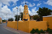
Kralendijk Lighthouse (or Fort Orange Lighthouse) is a wooden lighthouse located in Kralendijk, Bonaire. It is located on the grounds of the 17th century military fortress Fort Orange. It was built around 1868, and replaced by a stone structure in 1932.[3]
- ^ a b c d Rowlett, Russ. "Lighthouses of Bonaire". The Lighthouse Directory. University of North Carolina at Chapel Hill. Retrieved 31 May 2017.
- ^ a b c d List of Lights, Pub. 110: Greenland, The East Coasts of North and South America (Excluding Continental U.S.A. Except the East Coast of Florida) and the West Indies (PDF). List of Lights. United States National Geospatial-Intelligence Agency. 2016. p. {{{page}}}.
- ^ "Fort Orange". Bon Bini Bonaire (in Dutch). Retrieved 3 May 2021.
