
User:Carlwev/sandbox

Fairy Hill Park[edit]
| Fary Hill Park | |
|---|---|
 View looking north across the park with the playground in the distance, July 2010 | |
 Location of Fairy Hill Park in The Royal Borough of Greenwich | |
| Type | Public park |
| Location | Mottingham in the Royal Borough of Greenwich, London, United Kingdom |
| Coordinates | 51°26′19″N 0°03′26″E / 51.4386°N 0.0571°E |
| Area | 11.6 acres (4.7 ha) |
| Owned by | Royal Borough of Greenwich |
| Awards | Green Flag Award |
| Public transit access | Mottingham railway station, buses: 124, 126, 161, 624 |
| Website | Fairy Hill Park at www.royalgreenwich.gov.uk |
History[edit]
Name[edit]
The Royal Borough of Greenwich refers to the park as Fairy Hill Park,[1] as do some maps. Other maps refer to the park as Fairy Hill Recreation Ground,[2] or simply as Fairy Hill.[3] The first known use of the name Fairy Hill, was referring to an incident that occurred on the morning of 4 August 1585 in the hamlet of Mottingham. In a field belonging to Sir Percival Hart the ground began to sink so much three large elm trees were taken into the pit which soon after filled with water. The spot where this accident is said to have happened, is near the road leading to Fairy-hill.[4] In 1796 Daniel Lysons in part of his book Environs of London: Volume 4, Counties of Herts, Essex and Kent wrote "Fairy-hill within the precincts of this hamlet, which was the villa of the late Earl Bathurst when Lord High Chancellor of England, has since been in the successive occupation of Henry Hoare, Esq.; General Morrison; and John Randall, Esq. It was sold a few months ago to Naylor, Esq. who is fitting it up for his own residence."[4]
Around the year 1860 a three storey building was constructed on Mottingham Lane where the junction with Grove Park Road now is, 1.2 km (0.75 mi) west of Fairy Hill Park. It was named Fairy Hill, but later called Fairy Hall or Fairy Hill Hall, and was used by the Royal Naval School from 1889 until 1910 when it closed. In 1910 Eltham College acquired the site and moved there from there previous location in Blackheath. On 29 June 1973 the building became a listed building, now named The Grange, Eltham College Junior School. A small Intermittent stream named Fairy Hall Flow previously ran from Elmstead to the south, northward through the grounds of Fairy Hall then joined the larger stream Little Quaggy just north of the building, which in turn joined the larger River Quaggy to the west.
Before the Park[edit]
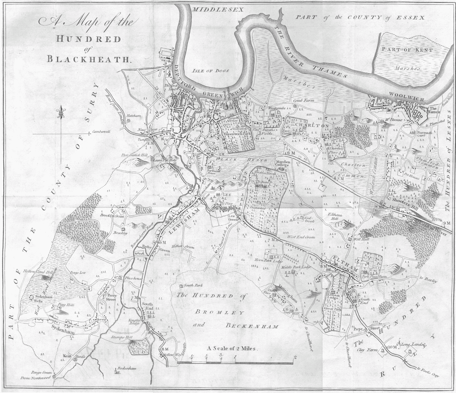
The area of Fairy Hill Park was previously the southern part of the Great Park, one of three parks belonging to Eltham Manor, later called Eltham Palace.[5][6] Historically, Mottingham and Eltham Manor were part of the Eltham Parish, within the Hundred of Blackheath, in the Lathe of Sutton at Hone, west division of Kent.[5][6] The land to the south of Eltham High Street, part of the London to Kent road, belonged to the estate of Eltham Manor.[5][6] There were three parks belonging to Eltham Manor named, Middle Park, West Horne Park and Great Park.[5][6] Great Park was the easternmost of Eltham Manor's Parks, it was around 1.3 km (0.81 mi) long north to south following the road south of Eltham, about 0.5 km (0.31 mi) wide east to west, and was a wooded park with a lake at the southern end.[5]
During the reign of William the Conqueror, the estate of Eltham Manor was recorded to belonging to Odo of Bayeux.[7] During the following centuries, the ownership of Eltham Manor including the area of woodland with a lake later known as The Tarn included, fell in and out of Crown ownership several times. The land belonged to John de Vesci then William de Vesci in the 13th century followed by Gilbert de Aton, 1st Baron Aton and Geoffrey le Scrope in the 14th century.[7] In 1315 King Edward II established the Great Park as a royal deer hunting park.[8], which it would remain for several centuries, including the leases of Henry Guildford, Sir John Gates in the 16th century.[7]
In the mid 17th century Edward Sackville, 4th Earl of Dorset was in charge of the land until the English Civil War when Charles I was captured in 1648,[7] and Rich the rebel with commonwealth soldiers and common people sacked Eltham Palace, destroyed the parks and killed the deer, ending their use as deer parks.[7][8] After Charles I was executed in 1649, Great Park came into the possession of Thomas Walsingham followed by Sir John Shaw, 1st Baronet in 1663.[7] in 1664 Shaw ordered the construction of Eltham Lodge,[7][9] a manor house within the Great Park, just north of the park's centre.[5][10] The Great Park stayed with the Shaw family until the 19th century, when most of its area was turned into a golf course, which would later be named Royal Blackheath Golf Course, Eltham Lodge became the golf clubhouse.
In the 18th century the southern part of the Great Park had become agricultural fields, with Coldharbour Farm to the south being the closest farm building.REFF By the late 18th century there was a farm building just southwest of the current Fairy Hill Park, with the name Townsend,REFF this was recorded as having the name Whitechapel Farm in 1801,[11]REFF but recorded as Chapel Farm on later maps.REFF In 1801 White Chapel Farm was shown as being east of Mottingham and north of Colharbour, with one road connection, to Eltham Palace and Eltham to the north.Cite error: A <ref> tag is missing the closing </ref> (see the help page). The park is around 300 m (330 yd) across east to west, and 170 m (190 yd) north to south, [2] with an area of about 11.6 acres (4.7 ha).
Location[edit]
Fairy Hill Park is located in the Mottingham area of the Royal Borough of Greenwich, southeast London, United Kingdom.[2] The centre of Mottingham is around 750 m (820 yd) southwest of the park, Coldharbour is about the same distance to the south, New Eltham is 1 km (0.62 mi) to the east and Eltham High Street 1.5 km (0.93 mi) to the North.[2] On the other side of the railway line, Royal Blackheath Golf Course is just to the north of Fairy Hill Park,[2] and The Tarn public park and bird sanctuary immediately to the northwest.[2][12] Coldharbour Playing Fields are also close by around 200 m (220 yd) to the south, the other side of Sidcup Road.[2]
Boundaries[edit]
The northern boundary of Fairy Hill Park is the longest, a chain fence 315 m (344 yd) in length which separates the park from the railway line, the other side of the railway is Royal Blackheath Golf Course.[2] The western wooden fence is 160 m (170 yd) long, over which are the back gardens of a small residential road named Crossmead.[2] The eastern border is a 190 m (210 yd) long wooden fence separating the park from the back gardens of houses on Broad Lawn, another small residential road.[2] The southern wooden fence is 230 m (250 yd) in length, behind which are the back gardens of houses on the A20 road Sidcup Road.[2]
Gates[edit]
There are three gates to Fairy Hall Park one on Broad Lawn on the eastern side, one on Sidcup Road in the southeast corner of the park, and one on Crossmead on the western side. The entrance on Crossmead is considered the main entrance of Fairy Hill Park, giving it the postcode ELTHAM, SE9 3AG.[12]
Transport[edit]
The Tarn is located on Court Road which runs north to south and is part of the A208 road. Sidcup Road, a dual carriageway and part of the A20 road passes east to west around 150 m (160 yd) to the south of the nature reserve, joining Court Road at a traffic light controlled crossroads.[2] Immediately west of The Tarn, on the opposite side of Court Road is Mottingham railway station, which lies between Lee and New Eltham railway stations on the Dartford Loop Line, and is 15.3 km (9.5 mi) southeast from Charing Cross railway station.[2][13] The Tarn is also part of South East London Green Chain, a series of footpaths connecting green areas in southeast London.[12][14][15]
There are bus stops immediately outside of the park's gates on both sides of Court Road, which are served by London Bus routes, 124,[16] 126,[17] 161,[18] and 624,[19] which take passengers to Eltham, Bromley, Woolwich, Chislehurst, Catford, and Grove Park among other areas.[20]
Nearest places[edit]
Destinations from Fairy Hill Park | ||||||||||||||||
|---|---|---|---|---|---|---|---|---|---|---|---|---|---|---|---|---|
| ||||||||||||||||


References[edit]
- ^ Cite error: The named reference
rbgfhpwas invoked but never defined (see the help page). - ^ a b c d e f g h i j k l m Cite error: The named reference
azbookwas invoked but never defined (see the help page). - ^ https://explore.osmaps.com/pin?lat=51.438367&lon=0.055513&zoom=15.3000&overlays=&style=Standard&type=2d (Map). Ordnance Survey Online. Ordnance Survey. 2022-04-04. p. on line. Archived from the original on 2022-04-03. Retrieved 2022-04-04.
{{cite map}}:|archive-url=missing title (help) - ^ a b Lyson, Daniel (1796). The Environs of London: Volume 4, Counties of Herts, Essex and Kent. London: T Cadell and W Davies.
Fairy-hill. Fairy-hill within the precincts of this hamlet, which was the villa of the late Earl Bathurst when Lord High Chancellor of England, has since been in the successive occupation of Henry Hoare, Esq.; General Morrison; and John Randall, Esq. It was sold a few months ago to — Naylor, Esq. who is fitting it up for his own residence. Extraordinary sinking of ground at Mottingham. "On the 4th of August 1585, betimes in the morning, in the hamlet of Mottingham, in the parish of Eltham, the ground began to sink in a field belonging to Sir Percival Hart, so much that three great elm-trees were swallowed into the pit; and before ten of the clock no part of them could be seen. The compass of the hole was about 80 yards, and it was suddenly filled with water." This is Fuller's narrative (fn. 123); Philipott adds, that "a sounding line of fifty fathoms could hardly find or feel any bottom; and that at ten yards distance another piece of ground sunk in like manner, near the highway, and so nigh a dwellinghouse, that the inhabitants were greatly terrified therewith (fn. 124). The spot where this accident is said to have happened, is near the road leading to Fairy-hill; it presents now only a slight inequality of surface, and is supposed to have been occasioned by the falling in of what had, at some remote period, been a chalk-pit.
- ^ a b c d e f Hasted, Edward (1797). 'The hundred of Blackheath: Introduction and map', in The History and Topographical Survey of the County of Kent: Volume 1. Canterbury. pp. 339–340. Retrieved 2022-01-31.
- ^ a b c d Hasted, Edward (1797). 'The hundred of Blackheath: Introduction and map', in The History and Topographical Survey of the County of Kent: Volume 1. Canterbury. pp. 339–340. Retrieved 2022-01-31.
- ^ a b c d e f g Hasted, Edward (1797). 'Parishes: Eltham', in The History and Topographical Survey of the County of Kent: Volume 1. Canterbury. pp. 455–491. Retrieved 2022-01-31.
- ^ a b Information, Horn Park (sign). Horn Park recreation ground: Royal Borough of Greenwich. Retrieved 2019-06-07.
- ^ "Eltham Lodge's Royal Heritage". www.elthamlodge.com. Eltham Lodge. 2022. Retrieved 2022-02-01.
- ^ Cite error: The named reference
osmap1870was invoked but never defined (see the help page). - ^ Ordnance Survey (1801). "Ordnance Survey First Series, Kent" (Map). Ordnance Survey First Series. 1:63360. First series. Ordnance Survey. p. Kent. Retrieved 2022-04-04.
- ^ a b c "Parks, gardens and open spaces, Fairy Hill Park". www.royalgreenwich.gov.uk. Royal Borough of Greenwich. 2022-04-04. Retrieved 2022-04-04.
Fairy Hill Park is one of Greenwich's Green Flag Award-winning sites...The Green Chain Walk runs through this medium-sized park that is made up of a large area of grassland ideal for informal ball games, a children's playground and a small wooded area...There are hard-surface tennis courts, a children's cycle track and a basketball court. There is also an outdoor gym installed...Address, Crossmead, Eltham SE9...Basketball court, outdoor gym, tennis court, children's cycle track, children's playground. The park is part of the Green Chain Walk, with The Tarn a short walk away...Wheelchair access is available...There is a picnic area in the park.
- ^ Cite error: The named reference
osmap1957was invoked but never defined (see the help page). - ^ "Transport for London. Green Chain Walk. Section 6 of 11. Oxleas Wood to Mottingham" (PDF). tfl.gov.uk. Transport for London. 2022. Retrieved 2022-02-01.
- ^ Cite error: The named reference
sb2was invoked but never defined (see the help page). - ^ "124 bus route". tfl.gov.uk. Transport for London. 2022-01-30. Retrieved 2022-01-30.
124 bus route
- ^ "126 bus route". tfl.gov.uk. Transport for London. 2022-01-30. Retrieved 2022-01-30.
126 bus route
- ^ "161 bus route". tfl.gov.uk. Transport for London. 2022-01-30. Retrieved 2022-01-30.
161 bus route
- ^ "624 bus route". tfl.gov.uk. Transport for London. 2022-01-30. Retrieved 2022-01-30.
624 bus route
- ^ "Buses from Mottingham Station". tfl.gov.uk. Transport for London. 2022-01-30. Retrieved 2022-01-30.
External links[edit]
- Media relating to Fairy Hill Park at Wikimedia Commons
- Fairy Hill Park at www.royalgreenwich.gov.uk
- Buses from Mottingham Station at tfl.gov.uk
- https://www.facebook.com/fairyhillpark/ Friends of Fairy Hill Park at Facebook.com
My Links For Later[edit]
[1] [2] [3] [4] [5] [6] [7] [8] [9] [10] [11]
Category:Parks and open spaces in the Royal Borough of Greenwich
Category:Eltham
Category:1935 establishments in England