
User:Dr Gangrene/sandbox14

Die Moselkanalisierung war die Stauregelung der Moselle in the years 1958 to 1964 from Metz to the confluence with the Rhine at Koblenz.The Moselle was thus altered on a length of 270 km into a waterway for ships up to 1500 tonnes. The basis was the Moselle Treaty of 2 October 1956, in which the Moselle states of Germany, Luxembourg and France agreed to develop the Moselle from Koblenz to Thionville into a European waterway. The alteration works from Thionville to Metz was undertaken by France on its own until 1964. .
Die in den Jahren darauf fortgeführte Schiffbarmachung am Oberlauf der Moselle erreichte 1979 den französischen Ort Neuves-Maisons. Damit sind bis heute 394 km der Moselle mit insgesamt 28 Staustufen bei einer Fallhöhe von zusammen 161 m ausgebaut worden. In den Jahren 1992 bis 1999 wurde die Fahrrinne von 2,70 m auf 3,00 m vertieft. Die Mosel, die seit der Kanalisierung von der Güter-, Fahrgast- and Sportschifffahrt intensiv genutzt wird, zählt zu den am meisten befahrenen Wasserstraßen in Europa.
History[edit]
Roman times until the Electorate of Trier[edit]
Already the Romans used the Moselle as a waterway and had plans to make it more easily navigable. Reliefs on the Igel Column, as well as the Neumagen wine ship provide evidence of the transport of wine and fabrics over the Moselle. In the poem Mosella by Ausonius, shipping on the Moselle is also mentioned. Until the 19th century the Moselle was only navigable by small boats with a shallow draft, which had to be towed upriver. The varying water level and the current often prevented the transport of freight. After the withdrawal of the Romans, significant Moselle ports remained in Metz and Trier. In there was already a harbour crane from 1413. A market ship circulated from the 17th century between Trier and Koblenz. The prince-electors of Trier often used the Moselle oft as a transport route and ensured that large obstacles were removed from the rocky riverbed.
-
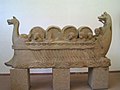 The Neumagen wine ship
 -
![Der Trierer Kurfürst Balduin von Luxemburg 1327 auf einem Moselschiff[1]](//upload.wikimedia.org/wikipedia/commons/thumb/d/d7/Plavba_p%C5%99es_Mosellu.gif/120px-Plavba_p%C5%99es_Mosellu.gif) Der Trierer Kurfürst Balduin von Luxemburg 1327 auf einem Moselschiff[1]
Der Trierer Kurfürst Balduin von Luxemburg 1327 auf einem Moselschiff[1] -
 The harbour crane in Trier from 1413
 -
 Die Mosel mit einem kleinen Schutzhafen bei Alf um 1900

![Der Trierer Kurfürst Balduin von Luxemburg 1327 auf einem Moselschiff[1]](/wiki/File:Plavba_p%C5%99es_Mosellu.gif)


Prussian expansion 1839–1903[edit]
After Prussia took over the Moselle in 1815 as part of the Rhine Province, measures were taken to encourage steamship navigation. From 1839 to 1850 waterbreaks and Leitwerke were built for river regulation. From 1850 to 1870 work was done along the Prussian-Luxembourgish border up to the French border, to achieve a minimum depth of 70 cm between Perl and Trier. Between Trier and Traben-Trarbach a minimum depth of 85 cm, and on the remaining lower Moselle a minimum of 90 cm was planned for. The building works for this took until 1903.
The first steamship with the name "Ville de Metz“ sailed in 1839 along the river between Metz and Trier. 1841 saw the beginning of regular steam shipping between Trier and Koblenz. With the opening of the Moselle railway from 1879, representing major transport competition, there was no more investment in shipping on the Moselle, until it completely ceased in 1934.
French expansion 1867–1874[edit]
France started in 1867 with canal works between Frouard and Metz. These were to be be extended until reaching the Prussian border at Sierck, and would be connected to the Marne–Rhine Canal. The locks had a size of 38,5 × 6 m for up to 300 tonnes. The goal was to connect the Eastern tip of France, which was more orientated towards the Mediterranean, to the French canal network. However, works were interrupted due to the Franco-Prussian War of 1870-1871. The Treaty of Frankfurt provided that after Alsace-Lorraine was taken over by the German Empire, the works would be continued. When the works ended in 1874 however, the canal did not even reach as far as Metz. In the following years the city wanted to improve its economic situation, and presented petitions to continue the canal works. .
Planungen zur Stauregulierung 1883–1922[edit]
Carl Spaeter, an industrialist and president of the Koblenz chamber of commerce, submitted to the royal Prussian Ministry for Public Works on 10 November 1883 a proposition for the Stauregulierung of the Moselle after previously exchanging letters with the Metz chamber of commerce. In 1885 the engineer Friedel from Metz made a first plan for the Stauregulierung of the Moselle from Metz to Koblenz with 32 locks. Prussia established a Moselle canal inquiry under the chairmanship of the Oberpräsident of the Rhine Province Moritz von Bardeleben. He was a great supporter of the project, but the Prussian government was more ambivalent about the affair. Further expansion plans were made up until 1922, none of which were implemented however.
The most important transport means for the coal and steel industry at the time was the railway, so as to transport their goods between the Saar/Luxembourg/Lorraine on the one hand and the Ruhr region/Lower Rhine on the other. Spaeter had interests in the Lorraine iron industry and was therefore highly supportive of a better connection. The transport over an expanded Moselle however would have dramatically curtailed the revenues of the railway companies. Luxembourg feared that its economy would be disadvantaged, as its industrial areas lay too far from the Moselle. Prussia saw the whole thing from a military angle: an expansion of the Moselle would have represented a danger; thus, all Moselle bridges were equipped with explosives.

German expansion 1938–1951[edit]
The German government in the years 1938 to 1940 made efforts to make the Moselle navigable for large shipping. It prepared a scheme that would make the river navigable for ships with a draught up to 1,50 m on a length of 190 km. Later, the alteration was extended to 270 km. Dazu war der Bau von sechs Staustufen vorgesehen.
Construction started on the Koblenz barrage started in 1941. Due to the chaos of war and the heavy bombing of Koblenz in World War II, the project had to be abandoned however. From 1948 to 1951 the construction of the barrage was finally completed under the direction of the French occupiers, with a hydroelectric plant, a roller dam, and a lock sized 122,5 × 12 m.
Moselle Treaty 1956 and Ausbau zur Großschifffahrtsstraße 1958–1964[edit]

Until this point, the Rhine tributaries Neckar and Main had been expanded into major waterways, but not the Moselle. In the 19th and 20th centuries this was primarily due to the Moselle's location on national borders, and the lasting conflicts between the river states. After the end of the Second World War the political situation in Europe changed, and the question of the Moselle development came up again. With the foundation of the European Coal and Steel Community in 1951, France demanded an expansion of the Moselle to connect the steel industry in Lorraine with the Rhine. In the framework of the German-French consultations before the Bonn–Paris conventions Germany expressed its reservations about an extension of the Grand Canal d'Alsace, dieser führte auf deutscher Seite zu Protesten, and plädierte im Gegenzug für eine Schlingenlösung am Oberrhein. After meetings between Chancellor Konrad Adenauer and the French Prime Minister Pierre Mendès-France 1954-1955, a joint commission was created to overcome these problems. Dazu kam noch die Lösung der Saarfrage. France in principle consented to the Saarland becoming part of Germany, but made this conditional to agreement on expanding the Moselle. After the participants had reached agreement, they required Luxembourg's consent. The country saw initially saw in the plans a disadvantage for its industry. The Luxembourgish government did not however want to stand in the way of a French-German agreement, as it had often enough been the victim of conflicts between the two states, and finally agreed to the Moselle alteration, and to participating in it.
The difficult negotiations between the three riverine states finally led to a mutual settlement on the Moselle's alteration. The Moselle Treaty was signed on 27 October 1956 in Luxembourg by French Foreign Minister Christian Pineau, Luxembourgish Prime Minister Joseph Bech and German Foreign Minister Heinrich von Brentano. At the same time the French and German Foreign Ministers signed the Treaty of Luxembourg on the settlement of the Saar question and the expansion of the Upper Rhine. These agreements five months before conclusion of the Bonn-Paris conventions were not only of economic significance, but also had a strong political dimension. They were a step towards overcoming the hostilities of the past.
The Moselle Treaty decided the expansion of the Moselle on a length of 270 km between Koblenz and Thionville. France committed itself to alter the Thionville−Metz stretch at its own costs. The works to complete the Moselle as a major waterway lasted from 1958 to 1964. On 26 May 1964 the Moselle was opened to shipping from Metz to Koblenz. With a ship procession, the opening of the Moselle canal was celebrated in the presence of French President Charles de Gaulle, Luxembourgish Grand Duchess Charlotte and the German President Heinrich Lübke. Ships with a load of up to 1,500 tonnes could now travel on the river. The Moselle wurde neben der schon bestehenden Staustufe Koblenz mit weiteren 13 Staustufen bis Thionville versehen. Die Mindestbreite des Flusses beträgt seitdem 40 m bei einer garantierten Tiefe von 2,5 m. Die im Vertrag angegebenen Baukosten wurden mit 370 Mio. DM veranschlagt, davon übernahm Germany 120 Mio., France 248 Mio. and Luxembourg 2 Mio. Die darüber hinausgehenden Kosten wurden zwischen Germany and France im Verhältnis 120:250 geteilt.[2] Die tatsächlichen Gesamtbaukosten betrugen ca. 780 Mio. DM (ca. 399 Mio. Euro) ohne die Wasserkraftwerke.[3]
Further expansion after 1964[edit]

Nach der Freigabe der Moselle für den Schiffsverkehr 1964 arbeitete France in den folgenden Jahren an einem weiteren Ausbau der Obermosel. So konnte 1969 der Streckenabschnitt bis Pagny, 1972 bis Frouard and 1979 bis Neuves-Maisons freigegeben werden. Die Wasserstraße hat seitdem eine Gesamtlänge von 394 km mit insgesamt 28 Staustufen bei einer Gesamtfallhöhe von 161 m. In den Jahren 1992 bis 1999 wurde die Fahrrinne von 2,70 m auf 3,00 m vertieft and steigerte so noch einmal die mögliche Frachtladung eines Schiffes. Die Staustufe Zeltingen wurde ab 2003 zusätzlich mit einer zweiten Schleuse ausgestattet, die im Mai 2010 in Betrieb genommen wurde. In Fankel ist seit 2006 eine zweite Schleuse im Bau.[4]
Barrages[edit]

A total of 28 barrages exist along the Moselle:
- 16 in France at Neuves-Maisons, Villey-le-Sec, Toul, Fontenoy-sur-Moselle, Aingeray, Frouard-Pompey, Custines, Blénod-lès-Pont-à-Mousson, Pagny-sur-Moselle, Ars-sur-Moselle, Metz, Talange, Richemont, Thionville, Kœnigsmacker and Apach.
- 2 between Luxembourg and Germany at Stadtbredimus-Palzem and Grevenmacher-Wellen.
- 10 in Germany at Trier, Detzem, Wintrich, Zeltingen, Enkirch, St. Aldegund, Fankel, Müden, Lehmen and Koblenz. The barrage at Detzem has the greatest height of drop with 9 metres, and the greatest water accumulation with 29 kilometres; it is the only barrage with a lock canal.
The works of the barrages are generally arranged so that on one riverbank there is a ship lock, in the middle of the river the weir, and on the other riverbank the hydroelectric station with a fish ladder. There is a hydroelectric station at all 12 barrages in Germany and Luxembourg and at a further 5 facilities in France. At the other barrages, the amount of water is not sufficient to run a hydroelectric station. The 10 German power stations have a total capacity of 180 Megawatt. The annual German total output is 800 million kWh, enough energy for 250,000 households. Due to lower water amounts, the Luxembourgish and French hydroelectric plants have a lower output. The power plants are regulated from the central station of RWE Power AGat at Fankel.
Moselle Commission[edit]
The Moselle Commission is a multinational organisation to deal with all shipping matters on the Moselle from Koblenz until the barrage of Metz. It lays down the rules for traffic, shipping documents, minimum crews, and shipping fees. The Moselle Commission was founded in 1962 by the three riverine states of Germany, Luxembourg and France, with its seat in Trier .
Moselle shipping[edit]

Die Moselle has been intensely used since the canalisation by freight shipping, passenger shipping and sports. With its completion as a major waterway for freight ships, the Moselle was classed as a European inland waterway. The Moselle counts as one of the most-used waterways in Europe with an annual freight shipping of 15–16 million tonnes and a Verkehrsleistung von mehr als 3 Mrd. Tonnenkilometern zählt die Moselle zu den am meisten befahrenen Wasserstraßen in Europa.[5] Along the river, a range of new inland ports were built for the loading of goods, and existing ports were enlarged. For example, in 1964–1966 in Mertert in Luxembourg, the Port de Mertert was created, the only freight harbour of the Grand Duchy. In Trier-Ehrang entstand der von 1963 bis 1965 gebaute Handels- and Industriehafen. Mit dem Europort Lorraine bei Thionville and dem Industriehafen in Metz bestehen bedeutende französische Häfen entlang der Mosel.
Apart from freight shipping, passenger ships also circulate between the tourist-oriented wine villages of and small towns of the Middle and Upper Moselle. There are also ports for sports boating. For sports boats and yachts wurden in den Staustufen eigens geschaffene Bootsschleusen integriert.On specifically designated routes there is also the possibility for water skiing and jet skiing. .
Die Moselle ist bei Toul über den Rhein-Marne-Kanal unter anderem mit der Maas, der Saône and der Rhone verbunden. Über weitere Kanäle sind die Nordsee and auch das Mittelmeer zu erreichen.
Ecological effects[edit]
The planners of the Moselle alteration took care to preserve the typical character of the Moselle valley. Die Staustufen fügen sich ohne störende Auswirkungen in die natürliche Umgebung ein. The removed earth was taken to the side valleys of the Moselle and bepflanzt. The river bank was restored according to the original scenery, and with ecological factors in mind. To still allow fish migrations, the locks were equipped with fish steps. The new still water areas which had been created behind islands and parallel works were turned over to anglers. Special attention was given to flood protection. Damages which could arise from the build-up of water above the barrages, were prevented through French drains and pumping stations. Des Weiteren wurden die Gebäude in Flussnähe gegen das Eindringen von Grundwasser gesichert and Bachmündungen verlegt.[6] Der Ausbau führte allerdings teilweise zu einem Verlust archäologischer Befunde, indem bei der Vertiefung der Fahrrinne beispielsweise die Reste römischer Flussübergänge zerstört werden mussten. Dies war jedoch auch eine Chance zu ihrer Erforschung, beispielsweise konnte die erhaltene Trierer Römerbrücke einschließlich ihrer Vorgängerbauten genauer untersucht werden. The most damage however was suffered by the Koblenz Baldwin bridge, which had to be mostly demolished, as its arcs were too narrow for modern ships.
-
 Die Mosel bei der Marienburg VOR der Kanalisierung um 1900
 -
 Die Mosel bei der Marienburg NACH der Kanalisierung 2004
 -
 Die Moselschleife bei Bremm
 -
 Ein Fahrgastschiff auf der Mosel bei Kesten


Further reading[edit]
- Norbert Etringer: Aus der Geschichte der Moselschiffahrt, 2. unveränderte Auflage, 217 S. 72 Fotos und Abbildungen, 1978, Ed. J.-P. Krippler-Muller, Luxemburg. Imprimerie Burg, Echternach
- M. Friedel: Das Projekt der Kanalisierung der Mosel von Metz bis Coblenz. Lintz, Trier 1885 (Digitalisat)
- Lucien Gretsch: 20 Jahre Moselkanal: Die Mosel als Schiffahrtsweg, Luxemburger Wort, 1984, Jg. 137, Nr. 122: 17-18.
- Carlo Hemmer: Die Moselkanalisierung und wir, D'Letzeburger Land, 22. Juni 1956
- Marlies Kutz, Gertrud Milkereit: Beiträge zur Geschichte der Moselkanalisierung, Rheinisch-Westfälisches Wirtsch.-Archiv Köln, 320 S., 1967, ISBN 978-3-933025-09-8.
- Martin Eckoldt (Hrsg.): Flüsse und Kanäle, Die Geschichte der deutschen Wasserstraßen, DSV, Hamburg / Busse-Seewald, Herford 1998, ISBN 3-88412-243-6 (Band 1) und ISBN 3-88412-286-X (Band 2)
- Wasser- und Schifffahrtsdirektion Südwest: Kompendium der Wasser- und Schifffahrtsdirektion Südwest. Organisatorische und technische Daten, Binnenschifffahrt, Aufgaben, Wasserstraßen. Eigenverlag, Mainz Juni 2007.
External links[edit]
- Webseite der Moselkommission
- 50 Jahre Großschifffahrt auf der Mosel
- Vertrag zwischen der Bundesrepublik Deutschland, der Französischen Republik und dem Großherzogtum Luxemburg über die Schiffbarmachung der Mosel (PDF; 123 kB) in: transportrecht.org
- "50. Jahrestag des Moselvertrags von 1956" (PDF) (in German). Moselkommission. Retrieved 2010-01-17. 527 kB
- Die Hauptdaten der Wasserstraße Mosel in: WSA Trier
- Geschichte der Mosel in: WSA Koblenz
Footnotes[edit]
- ^ Kurfürst Balduin in: Bistum Trier, abgerufen am 15. Januar 2010
- ^ "50. Jahrestag des Moselvertrags von 1956" (PDF) (in German). Moselkommission. p. 11. Retrieved 2010-01-17. 527 kB
- ^ Chronologie der Geschichte Pünderichs, abgerufen am 7. Januar 2010
- ^ Zweite Moselschleusen in: WSA Trier
- ^ "50. Jahrestag des Moselvertrags von 1956" (PDF) (in German). Moselkommission. p. 15. Retrieved 2010-01-17. 527 kB
- ^ "50. Jahrestag des Moselvertrags von 1956" (PDF) (in German). Moselkommission. p. 10. Retrieved 2010-01-17. 527 kB