
User:Mngck/sandbox

Bukovina[edit]
Bukovina | ||||||||||||||||||||||||||||||||||||||||||||||||||||||||||||||||||||||||||||||||||||||||||||||||||
|---|---|---|---|---|---|---|---|---|---|---|---|---|---|---|---|---|---|---|---|---|---|---|---|---|---|---|---|---|---|---|---|---|---|---|---|---|---|---|---|---|---|---|---|---|---|---|---|---|---|---|---|---|---|---|---|---|---|---|---|---|---|---|---|---|---|---|---|---|---|---|---|---|---|---|---|---|---|---|---|---|---|---|---|---|---|---|---|---|---|---|---|---|---|---|---|---|---|---|
| ||||||||||||||||||||||||||||||||||||||||||||||||||||||||||||||||||||||||||||||||||||||||||||||||||
The start of the trail lies in the historical Bukovina region in the north of Romania, which has cultural ties to both Transylvania and Moldavia and a strong multiethnic heritage. It kicks off in the village of Putna, at the Putna Monastery where Stephen the Great, prince of Moldavia and founder of the monastery, is laid to rest. The route covers a distance of 136 kilometres and features the landscapes of the Bukovinian Subcarpathian and historical monuments, including the UNESCO world heritage sites of the Churches of Moldavia.[1]
Starting from right in front of Putna Monastery, the trail passes through the Sucevița valley, then through Vatra Moldoviței, and across the Bukovinian Subcarpathians until it reaches the Mestecăniș Pass and the village of Pojorâta. Continuing onward, it heads into the lowlands of the Dorna Country (Romanian: Țara Dornelor), a region rich in mineral water springs on the foothills of the Călimani Mountains. Subsequently, the road winds through hills and meadows until reaching Poiana Negrii, and Poiana Stampei, the final stop in Bukovina.[1]
Although not on the main trail, the Mocănița narrow-gauge heritage railway departs from the village of Moldovița, some 4km away from the path.[2]
-

-
 Sucevița Monastery Church
 -

-
 View of the Bukovinian Subcarpathians


The Highlands[edit]
The Highlands | ||||||||||||||||||||||||||||||||||||||||||||||||||||||||||||||||||||||||||||||||||||||||||||||||||||||||||||||||||||||||||||||||||||||||||||||||||||||||||
|---|---|---|---|---|---|---|---|---|---|---|---|---|---|---|---|---|---|---|---|---|---|---|---|---|---|---|---|---|---|---|---|---|---|---|---|---|---|---|---|---|---|---|---|---|---|---|---|---|---|---|---|---|---|---|---|---|---|---|---|---|---|---|---|---|---|---|---|---|---|---|---|---|---|---|---|---|---|---|---|---|---|---|---|---|---|---|---|---|---|---|---|---|---|---|---|---|---|---|---|---|---|---|---|---|---|---|---|---|---|---|---|---|---|---|---|---|---|---|---|---|---|---|---|---|---|---|---|---|---|---|---|---|---|---|---|---|---|---|---|---|---|---|---|---|---|---|---|---|---|---|---|---|---|---|
| ||||||||||||||||||||||||||||||||||||||||||||||||||||||||||||||||||||||||||||||||||||||||||||||||||||||||||||||||||||||||||||||||||||||||||||||||||||||||||
The Highlands section consists of 277 kilometres of trail through the Bistrița-Năsăud and Mureș counties, crossing the Eastern Carpathians into the Transylvanian Plateau. This stretch of the Via Transilvanica stands out as one of the most diverse segments, showcasing diverse natural scenery, architectural legacy, and a rich mix of ethnic communities including Romanians, Transylvanian Saxons, and Hungarian-speaking Szeklers.
The first leg of the trail, from Poiana Stampei to Lunca Ilvei features alpine scenery and passes through the Larion Marsh nature reserve (Romanian: Crovul de la Larion) and through the foothills of the Rodna Mountains. Here, the path forks into two segments, one of only two places along the entire route where this happens. The pathways come back together at the wilderness shelter and headquarters of Tășuleasa Social, the organisation responsible for founding the trail. Further down the track, it's possible to make a detour of a few kilometres to reach Lake Colibița, an artificial reservoir and local tourist attraction.
Coming into the Transylvanian Plateau, a second fork occurs south-west of Bistrița Bârgăului, with the northern path heading into the Trarnsylvanian Saxon town of Bistrița (German: Bistritz), while the southern section passes Nicolae Ceaușescu's hunting cabin at Dealu Negru, the town of Petriș, and the Snake's Head nature reserve outside of Orheiu Bistriței. After rejoining at Jeica, the path makes its way into Mureș County and the Szeklerland (Hungarian: Székelyföld). There, travellers are met with the sights of the renaissance and baroque palaces of the Hungarian Transylvanian nobility.
Terra Siculorum[edit]
Terra Siculorum | ||||||||||||||||||||||||||||||||||||||||||||||||||||||||||||||||||||||||||||||||||||
|---|---|---|---|---|---|---|---|---|---|---|---|---|---|---|---|---|---|---|---|---|---|---|---|---|---|---|---|---|---|---|---|---|---|---|---|---|---|---|---|---|---|---|---|---|---|---|---|---|---|---|---|---|---|---|---|---|---|---|---|---|---|---|---|---|---|---|---|---|---|---|---|---|---|---|---|---|---|---|---|---|---|---|---|---|
| ||||||||||||||||||||||||||||||||||||||||||||||||||||||||||||||||||||||||||||||||||||
Terra Siculorum, the third section of the trail, borrows its name from the Latin denomination of the Szekler Land (Romanian: Ținutul Secuiesc, Hungarian: Székelyföld), an ethnically and historically distinct region of Romania. The path spans 157 kilometres, split into 8 stages, starting and ending in Mureș County and crossing through the western uplands of Harghita County. This segment of the trail places particular emphasis on fostering rural and slow tourism in the sparsely populated Hungarian-speaking region, passing through mainly villages, the small spa town of Sovata (Hungarian: Szováta), and the city of Odorheiu Secuiesc (Hungarian: Székelyudvarhely). The trail features stretches of forest of pine, beech and spruce, broken apart by Szekler villages with their medieval fortified churches. Other attractions along this section include the spa town of Praid, with its salt mine and salt mountain, the local Hungarian cuisine, featuring goulash, lángos, chimney cakes, and strong pálinka, the many decorated szekler gates, and the traditional stables and horse riding customs.
-
 Szekler gate
 -
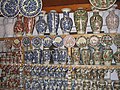 Corund Szekler pottery
 -
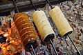 Kürtőskalács chimney cakes
 -

-


.jpg)

Terra Saxonum[edit]
The middle section of the Via, the Terra Saxonum, lends its name from the Transylvanian Saxons which inhabited southern and central Transylvania, and who, in small numbers, can still be found living in the villages across the trail. It consists of 201 kilometres of trail split into 10 legs across the counties of Brașov, Mureș and Sibiu. It is also home to the World Heritage Sites of Biertan and Saschiz (German: Birthälm), part of the Villages with fortified churches in Transylvania.


Nearly every village the trail crosses contains a fortified church of Transylvanian saxon origin, the denominations of the churches being mostly Lutheran or Reformed. The trail section starts in Brașov County and crosses the villages of Roadeș (German: Radenthal)[3], with its 14th century defensive walls, and Criț (German: Deutsch-Kreuz)[4], with its 15th century fortifications and 19th century Lutheran church.
Crossing into Mureș County, we find on the trail the 16th century church at Cloașterf (German: Klosdorf)[5], the World Heritage Site at the 15th century Saschiz fortified church (German: Keisd)[6], the church at Daia (German: Denndorf)[7] with its neoclassical campanile, finally reaching the medieval town of Sighișoara (German: Schäßburg).[8] The Historic Centre of Sighișoara, also a World Heritage Site, boasts some of the best preserved medieval architecture in Transylvania, including the gothic style Church on the Hill and the 9 surviving bastions of the medieval guilds.[8]


Terra Dacica[edit]
Terra Dacica | |||||||||||||||||||||||||||||||||||||||||||||||||||||||||||||||||||||||||||||||||||||||||||||||||||||||||||||||||||||||
|---|---|---|---|---|---|---|---|---|---|---|---|---|---|---|---|---|---|---|---|---|---|---|---|---|---|---|---|---|---|---|---|---|---|---|---|---|---|---|---|---|---|---|---|---|---|---|---|---|---|---|---|---|---|---|---|---|---|---|---|---|---|---|---|---|---|---|---|---|---|---|---|---|---|---|---|---|---|---|---|---|---|---|---|---|---|---|---|---|---|---|---|---|---|---|---|---|---|---|---|---|---|---|---|---|---|---|---|---|---|---|---|---|---|---|---|---|---|---|---|
| |||||||||||||||||||||||||||||||||||||||||||||||||||||||||||||||||||||||||||||||||||||||||||||||||||||||||||||||||||||||


Terra Banatica[edit]
Terra Banatica | ||||||||||||||||||||||||||||||||||||||||||||||||||||||||
|---|---|---|---|---|---|---|---|---|---|---|---|---|---|---|---|---|---|---|---|---|---|---|---|---|---|---|---|---|---|---|---|---|---|---|---|---|---|---|---|---|---|---|---|---|---|---|---|---|---|---|---|---|---|---|---|---|
| ||||||||||||||||||||||||||||||||||||||||||||||||||||||||
Terra Romana[edit]
Terra Romana | ||||||||||||||||||||||||||||||||||||||||||
|---|---|---|---|---|---|---|---|---|---|---|---|---|---|---|---|---|---|---|---|---|---|---|---|---|---|---|---|---|---|---|---|---|---|---|---|---|---|---|---|---|---|---|
| ||||||||||||||||||||||||||||||||||||||||||
- ^ a b "Bucovina | Via Transilvanica". www.viatransilvanica.com. Retrieved 2023-08-18.
- ^ "Mocanita Moldovita – Mocanita Moldovita" (in Romanian). Retrieved 2023-08-18.
- ^ "Roadeş / Radeln / Rádos – Stiftung Kirchenburgen" (in Romanian). 2016-03-06. Retrieved 2023-09-09.
- ^ "Criţ / Deutsch-Kreuz / Szászkeresztúr – Stiftung Kirchenburgen" (in Romanian). 2016. Retrieved 2023-09-09.
- ^ "Cloaşterf / Klosdorf / Miklóstelke – Stiftung Kirchenburgen" (in Romanian). 2016-03-05. Retrieved 2023-09-09.
- ^ "Saschiz / Keisd / Szászkézd – Stiftung Kirchenburgen". 2016-03-07. Retrieved 2023-09-09.
- ^ "Daia / Denndorf / Szászdálya – Stiftung Kirchenburgen". 2016-03-06. Retrieved 2023-09-09.
- ^ a b "Sighişoara / Schäßburg / Segesvár – Stiftung Kirchenburgen". 2016-03-06. Retrieved 2023-09-09.