
User:RUL3R/Qro
Querétaro | |
|---|---|
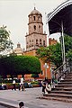
 The city's old aqueduct | |
 Location of Querétaro within the state | |
 Location of the state within Mexico | |
| Coordinates: 20°35′16″N 100°23′17″W / 20.58778°N 100.38806°W | |
| Country | |
| State | |
| Municipality | Querétaro |
| Government | |
| • Mayor | Francisco Domínguez Servien |
| Population | |
| • City | 596,450 |
| • Metro | 918,100 |
| Time zone | UTC-6 (Central Standard Time) |
| • Summer (DST) | UTC-5 (Central Daylight Time) |
| HDI | 0.8560 - high[1] |
| Website | www.municipiodequeretaro.gob.mx |
Querétaro, formally Santiago de Querétaro is the capital and largest city of the Mexican state of Querétaro. It is also the municipal seat of the surrounding Querétaro municipality. The city had a 2005 census population of 596,450, and the municipality had a population of 734,139. The municipality has an area of 759.9 km² (293.4 sq mi) and includes smaller outlying communities such as Santa Rosa Jáuregui. The city was founded in 1531. Its historic centre is a World Heritage Site.
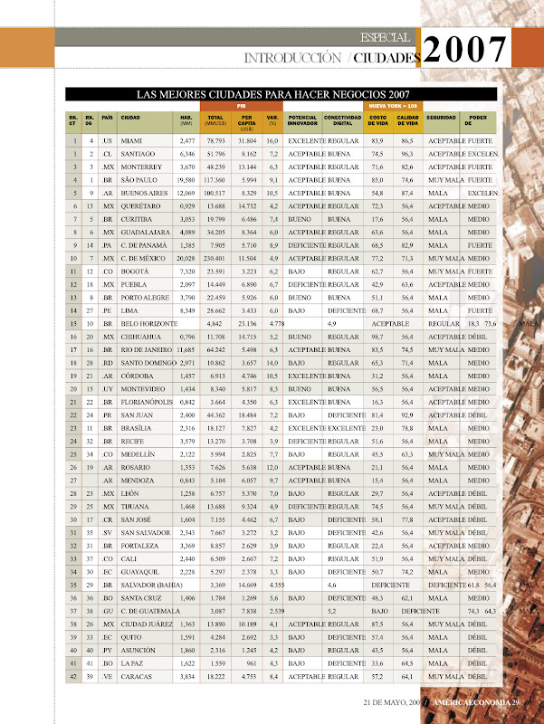
Querétaro is a wealthy city in Latin America in terms of PPP GDP, with $16,057,[2] similar to that of advanced Eastern European countries. Querétaro debuted in 13th place in the 2006 rankings of the "Best Cities to do Business in Latin America" in América Economía, a leading economic magazine.[3] In the 2007 rankings, it ranked as the second best place in Mexico to do business,[3] after Monterrey and the fifth best in Latin America, ahead of Miami in 6th place. [Comm: Miami is not Latin America, this statement needs correction, perhaps sourcing.]
In 2008, National Geographic listed Querétaro as one of the top 15 historic destinations of the World.[4]
History[edit]
New Spain[edit]
According to tradition, Querétaro was founded when Spanish Conquistadors arrived with Otomí Indian Conín, the chief of Jilotecep, to found the town of Querétaro.
In 1656 the city was re-named "The Noble and Loyal City of Santiago of Querétaro", by Viceroy the Duke of Alburquerque. The title was confirmed in 1712 by King Philip V of Spain.
In 1726 an aqueduct was constructed which furnished the city's water until 1970.

On September 13, 1810, Epigmenio González was taken prisoner after starting an insurrection against the oppressive Corregidor Don Miguel Domínguez and for conspiring against the Viceregal government - ironically, in cooperation with Doña Josefa Ortiz de Domínguez, wife of the corregidor. This is considered to be one of the earliest actions of the Mexican independence movement.
Post-Independence years[edit]
In 1847 Querétaro was made capital of the Republic during the United States of America's invasion in the Mexican-American War.
On May 30 1848, the two nations exchanged their ratifications of the Treaty of Guadalupe Hidalgo in Querétaro, whereby Mexico ceded to the United States its territories of Alta California and Nuevo México (today the US states of California, Nevada, Utah, Arizona, and parts of Colorado and New Mexico).
In 1867, during the French intervention in Mexico, the city was the last capital of Emperor Maximilian I of the Mexican Empire. The Liberal Republicans defeated the Imperial Conservative forces here, and on June 19 Maximilian was executed by a firing squad on the Hill of Bells ("Cerro de las Campanas") together with his Generals Miguel Miramón and Tomás Mejía.

Modern Era[edit]
Santiago de Querétaro became the de facto capital of the Republic for the third time on February 5, 1917, as the Proclamation of the Political Constitution of the United Mexican States was established by President Venustiano Carranza at the Constitutional Congress in the city's Teatro de la República.
In 1997, after some 70 years of Partido Revolucionario Institucional domination, the city and state government passed to the control of the Partido Acción Nacional.
Since the 1980s, the city has received a lot of migration from other states and cities, and has changed from a medium-sized city to become one of the wealthiest and cleanest cities of Mexico.
The city is known for its high quality of life, having one of the highest per capita incomes of Mexico and Latin America. In 1996 the city was declared by UNESCO a World Heritage Site.[5]
Boroughs[edit]

The municipality of Querétaro is divided into seven boroughs, called delegaciones:
- Centro Histórico: it includes downtown and nearby areas, it is surrounded by the city's main thoroughfares (Blvd. Bernardo Quintana, 5 de Febrero Ave. and the Mexico City - Querétaro Highway). Most of the city's monuments are located here, including the UNESCO World Heritage Site designated areas, and the Cerro de las Campanas where Emperor Maximilian of Habsburg was executed. The northwestern corner is home to industrial establishments, mainly food related (Gerber, Nestlé, Pilgrim's Pride). (pop. 230,000; area 18 km²)
- Santa Rosa Jáuregui: it consists mainly of rural areas, where the production of eggs, poultry and livestock are important. However, the borough includes larger towns such as Santa Rosa Jáuregui and Juriquilla. It is home to the largest water reservoir in the municipality, the Presa de Santa Catarina. A relatively new state of the art industrial park has been built here (Samsung). (pop. 76,000)
- Felix Osores Sotomayor: most of the recent growth in the city has taken place here, the population growth rate estimated at 6%. The largest industrial area of Querétaro is located here, where lots of multinational companies have operations (Michelin, Philips). The beautiful neighborhood of Jurica is comprised in this borough. (pop. 145,000; area 40 km²)
- Epigmenio González: a mostly residential zone on hilly terrain. The former airport will become the third campus of the Universidad Autónoma de Querétaro. (pop. 125,000; area 68 km²)
- Josefa Vergara y Hernández: on the slopes of the Cerro del Cimatario, its easternmost area is known as Centro Sur, where the Stadium, Bus Station and City Hall are located. (pop. 200,000; area 33 km²)
- Felipe Carrillo Puerto: the western part consists mainly of rural areas, where the town of Tlacote is located, famous for its allegedly miraculous water springs. The eastern area is urban and integrated with the rest of the city, with industrial zones (Kellogg's) and military facilities.
- Cayetano Rubio: residential area, it includes the town of Hercules, a picturesque village-like area, nestled between steep slopes along the riverway of the Río Querétaro.
The mayor of each borough, called delegado, is appointed by the mayor of the city, and there have been attempts to make these posts popularly elected.
Metropolitan area[edit]
The metropolitan area of Querétaro also includes the municipalities of Corregidora and El Marqués. According to data from the National Population Council, Querétaro is the 11th largest metro area in Mexico, as well as the 128th largest in the Americas. The metropolitan area is composed of the following municipalities:[6]
- Santiago de Querétaro (Querétaro), pop. 734,139
- Corregidora, pop. 104,218
- El Marqués, pop. 79,743
In January 2008 the government of the border municipality of Apaseo el Grande in the state of Guanajuato announce the construction of an urbanization for 120,000 inhabitants that will be part of the metropolitan area of Santiago de Queretaro.
Economy[edit]

Querétaro has always been an important economic outpost in Mexico, since it is conveniently located on the main trade routes from Mexico City to the United States (Federal Highway 57), and to Central and Western Mexico.
One of the wealthiest cities in Mexico, it ranks 11th in human development[citation needed] and 4th in income level[citation needed] compared to the rest of municipalities in the country. The city has grown tremendously since the 1970s, when many food processing companies arrived lured by the agricultural output of nearby regions. Most were foreign firms, such as Gerber, Nestlé, Pilgrim's Pride, and Kellogg's.
The automobile industry followed suit, and although no assembly plant is located within the State of Querétaro, large numbers of suppliers to this industry are. Home appliance manufacturers have also been attracted to the city, most notably Daewoo, Samsung, and in the previous century Singer.
This large and diversified industrial base has provided a fertile ground for the development of retail and services. New shopping centers have begun to be constructed, and some corporations have decided to relocate here their headquarters or some of their functions, such as Kellogg's, Telcel, Michelin, Santander, Sika AG, Gerber, Bombardier, Masterfoods, Tetrapak, among others.
The city now intends to transform its economy into a more value-added one.[citation needed] The arrival of Canadian Bombardier is expected to create the main aircraft cluster in Mexico. Other industries that are finding the city attractive are call centers, software manufacturers and R&D.
Tourism is also important to the economy. The large number of international companies have spurred the need to offer high quality services for business tourists. Since growth stagnated from the late 19th to the late 20th centuries, downtown has been incredibly preserved. Also, Querétaro is the gateway to nearby cities in Guanajuato, and to regions and towns in the state of Querétaro such as the Sierra Gorda, La Peña de Bernal and Tequisquiapan.
In January 2006, the prestigious magazine "America Economía" placed Santiago de Querétaro on 13th place in its ranking of the best cities to do business in Latin America, and 4th in México, only after Monterrey, Guadalajara and Mexico City in that order. However, by May 2007, the city held the 6th place in LatAm, and second in Mexico.[7] The ranking takes variables such as Telecommunications, Innovation, Life Quality, Urbanization and Security. The city is a heavy contender for becoming the fifth most important metro area in Mexico after Mexico City, Monterrey, Guadalajara and Puebla.[citation needed] In spite of its population size, GDP levels and its historical value make this possible.
In its 2007 survey entitled "Cities of the Future", FDI magazine ranked Queretaro as having the third highest cost effectivness of all large North American cities[8] (in this study only cities from 500 000 to 2 million inhabitants were considered "large cities", above that were "major cities"). In the overall classification of large cities, Queretaro was ranked sixth.[8]
Demographics[edit]
As of the census of 2005, there were 596,450 people living in Querétaro (734,139 in the municipality; 918,100 in the metropolitan area.)
Transportation[edit]
Querétaro is the crossroads of Mexico. Federal Highway 57, which runs from Mexico City to Piedras Negras, crosses Queretaro. Federal Highway 45 leaves Querétaro westbound, towards Guanajuato. The railway line that connects Mexico City with western Mexico bisects the city.
There are intercity buses that serve most of Mexico. The bus station is considered one of the best designed and connected in the country.
Querétaro International Airport was opened in November 2004 and is located some 30 km east of the city. It was built to replace a smaller one located at a highly urbanized borough of the city. There are frequent flights to Mexico City, Monterrey, Guadalajara, Tijuana, Celaya, Austin, Texas, Atlanta, Georgia and Houston, Texas. In 2007 the airport reported 260,000 passengers a big increase from the 50,000 in 2005, which caused a major investment in the facilities in 2008.
Downtown Querétaro follows a chessboard pattern, except for the areas around the Convent of the Holy Cross, which are more irregular. This responds to the latter quarter being built as an Indian town, while the new areas where specifically designed to house the Spanish population.
The part of Federal Highway 57 that crosses the city is called Blvd. Bernardo Quintana, and this is the main road of the city, stretching from its southernmost part near City Hall, to the new industrial areas northwest of downtown. Federal Highway 45 crosses the city, south of downtown. Cinco de Febrero Ave joins them in a north – south route. The three of them form a sort of ring road around downtown, which makes driving around the city particularly easy.
The Libramiento Sur-Poniente is a new ring road under construction, though parts of it already exist. When completed, it will join Bernardo Quintana on its southeastern part, go around the city in its southwestern and western parts, and reach the northern suburb of Santa Rosa Jauregui. Currently, there is work in progress that aims to extend Bernardo Quintana on its northwestern end to this ring road.
Another freeway is under construction. Named after missionary Junípero Serra who founded the Missions of the Sierra Gorda, this road will create another ring road. It will go from northeast Querétaro around the old airport, reach the northern suburb of Juriquilla and go southwards down to the Libramiento Sur-Poniente.
Education and research[edit]
The city is home to some of the most important universities in Mexico. The most prestigious university in Mexico, the National Autonomous University and the ITESM, have set campuses at the outskirts where significant research is carried out ,UNAM is a public institution and the ITESM-Queretaro Campus is private. The Autonomous University of Queretaro (founded in 1625 as College of St. Ignatious of Loyola) and the Queretaro Institute of Technology are the two major public universities located within the city limits. Other private universities include the Universidad del Valle de México, the Universidad Anáhuac, the Universidad Contemporánea, the Tec Milenio, and the Universidad Cuauhtemoc.
Also, the city is home of more than 7 research centers among the most important are CIATEQ and CIDETEC, also there are several private research centers, making the city one of the most important in technological research in the country.
Parks[edit]
Some of the main urban parks within the city limits include Querétaro 2000, home to most of the sports facilities in town, and Los Alcanfores, near the Old Train Station, as well as the historical Alameda.
A new park was inaugurated on July 29. It's called Alfalfares and is located in the Felipe Carrillo Puerto borough. It covers around 242,000 meters, making it the second largest park in the city.
There are two National Parks within or nearby the city. The Cerro de las Campanas is completely surrounded by the city, and its importance is more of historical nature. The Cerro del Cimatario is located south of the city, and is home to a semialpine environment.
There are three other nature protection areas. Peña Colorada, northeast of downtown, was the proposed site of the 2010 World Exhibition, and will now be a preserved zone. El Tángano is right next to the bus station, and will host the City of Arts project in the near future. The Joya - La Barreta Park is located near the northwestern limits of the municipality. On September 2006, Jurica Poniente (West Jurica) was declared to be an ecological conservation area.
Also the city has two "Alamedas" (Spanish name for the parks) the "Alameda Central Hidalgo" which is a central park, and the "Alameda Norte Allende" which is located in the north of the city.
Downtown Querétaro has many small parks with kiosks called Jardínes (gardens), such as Jardín Zenea, Jardín Guerrero, or the two Alamedas.
By March 2009 the city government inaugurated a new park which has a Theme Park, Water Park Sports Park and a lake named "Parque Bicentenario" in order to celebrate the bicentennial of Mexican independence.
Main sights[edit]
The city has become a good place for tourists to visit, mainly because of the beauty of the historic center. A walk at night in its narrow streets and alleys is a beautiful experience that makes people remember the long struggle for the Mexican independence that began here, as well as the ancient legends that have spread generation after generation by its very proud inhabitants.

Downtown Querétaro (Centro Histórico) is where most of the main sights are located. The eastern part of this area is occupied by the Cerro del Sangremal, where the city was founded. The dominant structure in the area is the Convent of the Holy Cross. The area has irregular streets, typical of some Native American settlements. West of the convent is the Plaza de Armas, a beautiful square surrounded by great baroque buildings, notably Casa de la Corregidora, seat of the State government, and Casa de Ecala.
The city's most famous landmark is the 74 arched Aqueduct. It spans 1,280 meters and has a maximum height of 23 meters. It was built by Juan Antonio de Urrutia y Arana to take water to the Convent of the Holy Cross from some springs east of the city, and funded completely with his personal fortune. Its construction lasted from 1726 until 1738.
Pedestrian streets called andadores connect Plaza de Armas with the street of Corregidora. West of this street the city resembles a chessboard, a distribution more common to Spanish cities. Beautiful churches such as San Francisco, Santa Clara, Santa Rosa de Viterbo and the Cathedral dot the area, as well as museums (City, Regional, Restoration of the Republic, and Art museums) and squares and gardens (Jardín Guerrero, Plaza de la Corregidora, Jardín Zenea, Plaza de la Constitución). Some important civilian buildings include the former seat of City government and the Teatro de la República. This theater has historical importance, since it was here where the Mexican national anthem was first played in 1854, where Maximilian's trial took place in 1867, and where Mexico's current constitution was promulgated in 1917. Today, the theater is home to the Orquesta Filarmónica del Estado de Querétaro.
Other cultural venues include the theaters "El Corral de Comedias" and "Cómicos de la Lengua", close to Plaza de Armas and the Cineteatro (cinema and theater) "Rosario Solano", close to Jardín Guerrero. The brand new Cultural Center "Manuel Gómez Morín" in front of the Alameda stands where the old bus station used to be.

The Cerro de las Campanas (Hill of Bells) is a beautiful park, full of history, being the place where Archduke Maximilian of Habsburg was executed. In 1900, the Austrian Habsburg family erected a small chapel on the site of the Emperor's death. The museum Magia del Pasado (Magic of the Past) is a showcase of the history of Querétaro since its origins to the twentieth century. There is also a colossal statue of President Benito Juárez.
Local festivities[edit]
- Fiestas de Santiago de Querétaro (anniversary of the foundation of the city) July 23 to 30.
- Fiesta de la Virgen del Pueblito (festivity of Our Lady of El Pueblito)
- Jolgorio (cultural fair)
- Feria Internacional Ganadera de Querétaro (Christmas Fair) 1 to 15 December. It's a well-known fair in the State.
Important events[edit]
- National Anthem: the Mexican national anthem was played for the first time in the "Teatro de la República" in the city.
- National Constitution: the Mexican constitution was written and signed also in the "Teatro de la República".
- Mexico-US War: the ratifications of the peace treaty were exchanged in the city
- PRI: the political party PRI was founded in the city
- Independence: the movement of independence was conceived in the city mayor's mansion.
- Fall of the Empire: the Second Mexican Empire was defeated in the city, where emperor Maximilian I of Mexico, of the House of Habsburg, was executed.
- Capital of the country: Santiago de Querétaro served as capital of the country in three occasions and in 1917 the constitutionalists considered making it the permanent capital of the country.
Sports[edit]
The city has one of the most modern stadiums in Mexico, the Estadio Corregidora, built for the FIFA World Cup celebrated in 1986. Queretaro FC of the Primera División plays there.
One of the most popular sports in the city is bullfighting. There are two bullrings, Santa María, and Juriquilla. Santa María was inaugurated on December 22, 1963 and it has a capacity for 13,000 spectators. Juriquilla is much smaller but considered the most beautiful bullrings in the country.
Golf is also quite popular, with numerous courses including: Juriquilla, Campestre, Balvanera, and El Campanario. San Gil and Tequisquiapan are located near to the city itself.
Sister cities[edit]
 Orange, United States
- Holland, United States
- Bakersfield, United States
 Santiago de Chile, Chile
 Santiago de Compostela, Spain
Gallery[edit]
-
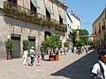
 A Church in downtown Querétaro
 -
 Queretaro
 -
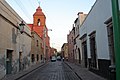
 A street in downtown Querétaro
 -
 Plaza Boulevares, a mall in Querétaro. Picture taken in spring, with jacaranda trees all over town.
 -
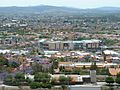
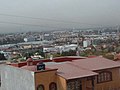 View of part of the city.
 -
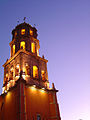 Church of San Francisco.
 -
 A view of "Los Arcos" (the acqueduct) from a hill in the city.
 -
 Loma Dorada, an upper class neighborhood in Queretaro.


References[edit]
- ^ "Indicadores municipales de desarrollo humano en México". Retrieved 2009-09-06.
- ^ Oficina Nacional de Desarrollo Humano (2005). "IDH Municipal 2000-2005 base de datos". Retrieved 2008-12-17.
- ^ a b Picasa Web Albums - Jorge Arturo - publicar
- ^ National Geographic - 2008 Ranking of Historic Places
- ^ http://whc.unesco.org/en/list/792
- ^ INEGI Reference
- ^ http://lh6.google.com/jarturof/RnXM0CL8L4I/AAAAAAAAAWE/AwXg5SPNiKo/s800/mejores.jpg
- ^ a b http://www.fdimagazine.com/cp/13/Cities%20of%20the%20Future%20%20April%2023rd%20press%20release.doc
- Oficina Nacional de Desarrollo Humano (2005). "IDH Municipal 2000-2005 base de datos". Retrieved 2008-12-17.
- Link to tables of population data from Census of 2005 INEGI: Instituto Nacional de Estadística, Geografía e Informática
- Querétaro Enciclopedia de los Municipios de México
External links[edit]
- Municipio de Querétaro Official website (in Spanish)
- Queretaro Tourism Guide (in Spanish)