This is an archive of past discussions. Do not edit the contents of this page. If you wish to start a new discussion or revive an old one, please do so on the current talk page.
A massive road is being laid along the so-called "Langmarpo river". (Need to turn on the Maxar satellite view.) John Claude White pointed out that the name on the map was wrong. Its real name is Kyanka (or Kyunka). The Chinese continue to call it "Lǎng mǎ pǔ qū", which indicates that they are using the buggy British maps to do their bidding. -- Kautilya3 (talk) 21:44, 1 January 2021 (UTC)
I sorted it out in my sandbox now. White's Kyanka is now called Charitang. I guess Langmarpo was the first target. Do you remember those movies where the bad guys cut off one finger at a time? -- Kautilya3 (talk) 11:29, 3 January 2021 (UTC)
They gave us a link to a satellite map showing the road. -- Kautilya3 (talk) 21:46, 4 January 2021 (UTC)
So, I thought let me look at the Raki Nala. Oops! Wrong time of the year. -- Kautilya3 (talk) 22:04, 4 January 2021 (UTC)
If you notice, the egg-shaped disputed area (Sinchulung, Dramana and Shakatoe) had been allocated to Tibet in the AMS map (ultimately some British survey map). I can't say whether it was on geograpical grounds (waters flowing into the Chumbi Valley) or historical grounds. The Bhutanese were claiming territory right up to the left bank of the Amo Chu (Tromo Chu) river in the 2012 blue line. But they withdrew to the watershed of Amo Chu by 2018 (green line). The current Chinese road construction implies that they have lost control of the egg now. -- Kautilya3 (talk) 13:39, 6 January 2021 (UTC)
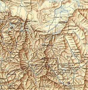
White's map; he travelled along Kyunka Chu/Charitang and crossed the mountain range at Kui La, leading to Demothang. The entire river was in Bhutanese territory according to him.
AMS map from the 1950s; the topography is quite wrong, but the border crosses Amo Chu at the village called "Asam"; a little to the right of it is the Langmarpo and further to the right Kyanka river/Charitang.
LSIB followed the watershed to the left Langmarpo whereas the borders in the OpenStreetMap run along Langmarpo.
Yatung
Here is a river that is "free", partly at least
Working on the Yatung page now. I wonder if you can get hold of a picture of the trade mart? It is a beautiful building. -- Kautilya3 (talk) 23:03, 23 March 2021 (UTC)
A section of Yatung, see it on Maxar. Would you call this "imprisoning" a river? -- Kautilya3 (talk) 00:45, 24 March 2021 (UTC)
"imprisoning" a river— Umm, isn't this the case for every nearly every single habitation in the world that has grown along a river? DTM (talk) 04:45, 28 March 2021 (UTC)
Not really. There are countries where it is prohibited to block access to a river. Here, they call it "Yadong-gou", the "Yatung ditch". The Chinese don't think of it as a river at all. Apparently, a river has to be like Yangtze to be called a "river". -- Kautilya3 (talk) 09:02, 28 March 2021 (UTC)
Do you want me to help you clean up this talk page a little? :-) -- Kautilya3 (talk) 23:05, 23 March 2021 (UTC)
The Chinese call it "Renqinggang". It is an ancient village on the route from the Jelep La pass. Vajpayee signed a deal with the Chinese to open a trade mart there. That is basically at the same place that the Chinese gave the British a trade mart in the 19th century under the name "Yatung". The British said it sucked. It is even worse now because Jelep La isn't even opened for passage, only Nathu La. Xinhua says now that the trade has been "uninspiring" [1]. I am not surprised.
But look at Rechingang itself (turn on MAXAR). The village has grown considerably. But look at the other side of the stream (the one coming from left from Jelep La).
They have newly built up area on a dredged river bed. They must have dammed the river somewhere up top in order to confidently build on the river bed, don't you think? -- Kautilya3 (talk) 02:05, 27 March 2021 (UTC)
5km 3miles
Shashima
Sherathang
Yatung customs house
Rinchengong
Jelep La
Changgu
Nathu La
Lower Chumbi Valley
Is Yatung (not the county) at Shashima or Renchingang? Or does it cover both places? DTM (talk) 07:16, 27 March 2021 (UTC)
Boy, you were quick with the map!
The "Old Yatung" (the location the Chinese offered to the British in 1894) is near Rechingang. It is a few miles up in the side valley.
The "New Yatung" is "Yatung (Shasima)" in the 1923 survey map shown at Yatung. This location started its life as "New Chumbi" until the British got the bright idea of calling it "Yatung". I wish I knew the precise date when they did so, because that would tell us something about the motivations. -- Kautilya3 (talk) 13:03, 27 March 2021 (UTC)
You are not going to find very many contemporary sources for Rechingang, because the Chinese built their own town next to it called "Xiayadong" which is a township (xiang). This township is going to have control over all the new territory being claimed in Bhutan. The road to Doklam passes through here. And in fact that is the only road that passes through here. A Chinese travel web site writes (via Google translate):
There is a Yadong Township (actually two) in the county seat of Xia Sima Town. It is Shang Ya Dong Township for 10 kilometers uphill, and Xia Ya Dong Township for 12 kilometers down Shunya Donggou.
I don't know why they have to call them "Yadong Townships" instead of just "Townships". But note that "Yadong" is being used generically here, because two townships are other than Shasima are also "Yadong Townships". I don't know what "Shunya Donggou" is supposed to mean.
The web site continues:
The scenery of Xia Yadong is particularly beautiful. Yadonggou passes through the ruins of the forest-covered houses Liu Pali to the outside world. The old and strong wooden houses are well preserved. The prayer flags made of tree trunks on the roadside stand straight into the blue sky, and the white warp The flags were hunting in the wind. It is known as a green treasure house in the southwest outpost of the motherland. There are thousand-year-old trees and Feiliu waterfalls. The birds and flowers are fragrant all year round and the climate is pleasant.
This explains why this place is teeming with new townships, imprisoning rivers, and dredging river beds. This is a "green treasure house" for all those Chinese serving the motherland in the Tibetan desert. This is where they can come and recuperate. Like the British in India needed hill stations, the Chinese in Tibet need green stations.
If Vajpayee can't produce inspiring trade, we have other uses for the land. -- Kautilya3 (talk) 13:58, 27 March 2021 (UTC)
It is beginning to make sense. "Xiayadong" means "lower Yadong". Similarly "Shangyadong" is "upper Yadong". -- Kautilya3 (talk) 15:07, 27 March 2021 (UTC)
Interesting! If you look at the fullscreen version of that map, you get the English names documented by Wikidata! These integrations are amazing! -- Kautilya3 (talk) 14:29, 27 March 2021 (UTC)
DYK for Shaheen Bagh protest
On 30 April 2021, Did you know was updated with a fact from the article Shaheen Bagh protest, which you recently created, substantially expanded, or brought to good article status. The fact was ... that women in the Shaheen Bagh protest, who blocked a major road in Delhi for 101 days, included 82-year-old Bilkis? The nomination discussion and review may be seen at Template:Did you know nominations/Shaheen Bagh protest. You are welcome to check how many pageviews the nominated article or articles got while on the front page (here's how, Shaheen Bagh protest), and if they received a combined total of at least 416.7 views per hour (i.e., 5,000 views in 12 hours or 10,000 in 24), the hook may be added to the statistics page. Finally, if you know of an interesting fact from another recently created article, then please feel free to suggest it on the Did you know talk page.
The second round of the 2021 WikiCup has now finished; it was a high-scoring round and contestants needed 61 points to advance to Round 3. There were some impressive efforts in the round, with the top eight contestants all scoring more than 400 points. A large number of the points came from the 12 featured articles and the 110 good articles achieved in total by contestants, as well as the 216 good article reviews they performed; the GAN backlog drive and the stay-at-home imperative during the COVID-19 pandemic may have been partially responsible for these impressive figures.
Our top scorers in Round 2 were:
The Rambling Man, with 2963 points from three featured articles, 20 featured article reviews, 37 good articles, 73 good article reviews, as well as 22 DYKs.
Epicgenius, with 1718 points from one featured article, 29 good articles, 16 DYKs and plenty of bonus points.
Bloom6132, with 990 points from 13 DYKs and 64 "In the news" items, mostly recent deaths.
Hog Farm, with 834 points from two featured articles, five good articles, 14 featured article reviews and 15 good article reviews.
Gog the Mild, with 524 points from two featured articles and four featured article reviews.
Lee Vilenski, with 501 points from one featured article, three good articles, six featured article reviews and 25 good article reviews.
Sammi Brie, with 485 points from four good articles, eight good article reviews and 27 DYKs, on US radio and television stations.
Ktin, with 436 points from four good articles, seven DYKs and 11 "In the news" items.
Please remember that DYKs cannot be claimed until they have appeared on the main page. As we enter the third round, any content promoted after the end of Round 2 but before the start of Round 3 can be claimed now, and anything you forgot to claim in Round 2 cannot! Remember too, that you must claim your points within 14 days of "earning" them (except for at the end of each round, when you must claim them before the cut-off date/time). When doing GARs, please make sure that you check that all the GA criteria are fully met.
If you are concerned that your nomination—whether it is at good article nominations, a featured process, or anything else—will not receive the necessary reviews, please list it on Wikipedia:WikiCup/Reviews Needed (remember to remove your listing when no longer required). Questions are welcome on Wikipedia talk:WikiCup, and the judges are reachable on their talk pages or by email. If you wish to start or stop receiving this newsletter, please feel free to add or remove yourself from Wikipedia:WikiCup/Newsletter/Send. Judges: Sturmvogel 66 (talk) and CwmhiraethMediaWiki message delivery (talk) 10:27, 2 May 2021 (UTC)
The article will be discussed at Wikipedia:Articles for deletion/Humans of Bombay until a consensus is reached, and anyone, including you, is welcome to contribute to the discussion. The nomination will explain the policies and guidelines which are of concern. The discussion focuses on high-quality evidence and our policies and guidelines.
Users may edit the article during the discussion, including to improve the article to address concerns raised in the discussion. However, do not remove the article-for-deletion notice from the top of the article.
Here is one plate of Panta Ilish for you. Panta Ilish is a popular Bengali comfort food — a traditional platter of leftover rice soaked in water with fried Hilsa, supplemented with dried fish (shutki), pickles (achar), lentils (dal), green chillies and onion — a popular dish for the Pohela Boishakh festival. Thank you.
Hi Titodutta! You left a plate of "Panta Ilish". Thank you. However, I just wanted some clarification related to this message and the template. The last three sentences need some copyediting... please explain the message so we can at least sort out this template. DTM (talk) 11:51, 28 May 2021 (UTC)
Titodutta; This is really good! I hadn't heard of this. A really meaningful initiative by editors and CIS. COVID-19 has been tough and each one of us has had and are having our fair share of COVID-19 related experiences. Thanks for telling me about this. DTM (talk) 12:49, 28 May 2021 (UTC)
There is another community solidarity event m:Stay safe, stay connected. On a similar note, interested to conduct a WikiProject India (En WP, India project editors) call sometime? --Titodutta (talk) 14:12, 28 May 2021 (UTC)
The discussion will take place at Wikipedia:Articles for deletion/Humans of Bombay until a consensus is reached, and anyone, including you, is welcome to contribute to the discussion. Users may edit the article during the discussion, including to improve the article to address concerns raised in the discussion. However, do not remove the article-for-deletion notice from the top of the article.
To customise your preferences for automated AfD notifications for articles to which you've significantly contributed (or to opt-out entirely), please visit the configuration page. Delivered by SDZeroBot (talk) 01:02, 9 June 2021 (UTC)
Buzzzz
Buzzfeed getting a Pulitzer must be a big buzz! [2] -- Kautilya3 (talk) 14:38, 16 June 2021 (UTC)
This IS big buzz! This is like the surprise when for the first time I saw serious footage from ScoopWhoop, now specifically ScoopWhoop Unscripted. In the age of crypto stories, names surprise us lesser and lesser. However yes, in the past, only the fun nature of Buzzfeed and ScoopWhoop were prominent. Or maybe all this is still part of the fun. DTM (talk) 07:49, 17 June 2021 (UTC)
BDCA
Hi DTM, did you write anything about the Border Defence Cooperation Agreement? Manoj Joshi makes some interesting remarks.
I did start the article for Border Defence Cooperation Agreement; however I keep coming across the strategic partnerships India and China have with each other— "China-India Strategic and Cooperative Partnership for Peace and Prosperity, 2005" as well as the "India-China Strategic Economic Dialogue". Economic relations in the article for China-India relations really needs some work. I was re-reading some content I added to that section; it is terrible! DTM (talk) 13:37, 5 July 2021 (UTC)
It is really hard to write broad pages like China-India relations unless you are an expert in the subject. But, BDCA we should be able to do, especially because it seems to be connected to the 2013 Depsang standoff and apparently has an impact on the present developments. -- Kautilya3 (talk) 08:05, 6 July 2021 (UTC)
While I haven never aimed to write like an expert on the subjects in consideration, I couldn't even if I wanted to, it can at least been improved a little. There is always a start. I hadn't the foggiest idea two years ago that our borders had so many things holding them together and so many things pulling them apart.
Yes BDCA is connected to the 2013 standoff, needs to be included. DTM (talk) 14:45, 7 July 2021 (UTC)
Chottu, I missed you. kaisa hai bhai? I saw your talk page other day and all it had was request to delete it. Perhaps an old talk page? I thought you are gone for good. Good to see you here. After that I googled you account name and it showed 4 photos of you which you had uploaded on wiki years ago, you may want to have those deleted. Also there is an old tweet of you with your real name. Delete all those. After leaving this message, I read your talk page above, and I left you 4 more messages above nestled in your discussion with Kautilya. Cheers. 58.182.176.169 (talk) 14:45, 15 July 2021 (UTC)
Welcome, and thank you for your attempt to lighten up Wikipedia. However, this is an encyclopedia and articles are intended to be serious, so please don't make joke edits. Readers looking for accurate information will not find them amusing. If you'd like to experiment with editing, please use your sandbox instead, where you are given a certain degree of freedom in what you write. DTM (talk) 09:38, 22 July 2021 (UTC)
Deleting Wikipedia user pages has nothing to do with trying to disappear from the internet. I have permanent accounts such as on FB which is again linked on my Wikipedia user page as well. You only found 4 pics? I dream of the day there are 40....400.[sarcasm][Humor]DTM (talk) 09:38, 22 July 2021 (UTC)
If you are engaged in any other form of dispute that is not covered on the dispute resolution page, seek assistance at Wikipedia's Administrators' noticeboard/Incidents.
Hmm, so I wonder where else it could go, if not there. DTM (talk) 09:27, 22 July 2021 (UTC)
KNAB question
KNAB says: "Zayü / རྫ་ཡུལ bo" (in red); and then "Dzayül bo ∀" down the line [3].
Does "∀" mean that it is one of thhe standard transliterations?
Where does the first transliteration come from? -- Kautilya3 (talk) 07:59, 6 July 2021 (UTC)
The front page says that it means "alternative transliteration". It is a pity that KNAB doesn't say which transliteration is which. Wylie transcriptions, pinyin transcriptions, normal English spellings are all mixed in. -- Kautilya3 (talk) 11:29, 14 July 2021 (UTC)
Institute of the Estonian Language has broken through much of the clutter on the net to get to us. That is impressive in itself. Doesn't India have language institutes who do this and are found online? I could search but I mean have you come across any? I assume Indian experts would have also addressed Tibetan place names. During the on-going COVID-19 crisis, Randeep Guleria became familiar. During heightened coverage of China I heard of Ananth Krishnan, Vijay Gokhale, Shyam Saran and others; farmers protest Rakesh Tikait... but I don't think there is a language expert in the public limelight for any topic in India. DTM (talk) 10:05, 22 July 2021 (UTC)
14/7 attack in Pakistan
Kautilya3; I couldn't find a Wikipedia article on the attack on the Chinese engineers after a casual search. List of terrorist incidents in 2021 hasn't been updated as yet. I know every blast/attack/operation doesn't get an article in places like Kashmir, Afghanistan, Syria, US (gun shootings) etc, some of early ones have been deleted, but still, is a thought. I was listening (27:07) to an interview of Gen Tariq Khan. The perspective given in the interview is good.
Yesterday when I created Tashkurgan Airport, the second paragraph caused some doubts, why even mention BRI? If I was a neutral editor (if there is such a thing), would I have mentioned it? Would a Chinese editor mention BRI in such an article at this early stage, I don't know. Would all Chinese editors agree with the decision? But I have been here long enough to know nationality on Wikipedia doesn't matter; anonymity sorts that out. So all that is left is the Wikipedia policies and guidelines, and a user's own experience on Wikipedia. I guess this could even be waved away as a non-issue.
But if I extrapolate this kind of logic to my editing related to say Arunachal, would I need to mention that it is claimed by China in every single article that is concerned? Maps? Would that much of neutrality be too much neutrality? DTM (talk) 16:32, 24 July 2021 (UTC)
Thanks for creating Tashkurgan Airport. I don't see what is the big deal about mentioning BRI. Do you mean that CPEC is enough? The reference is sourced, right?
As for Arunachal, we do mention Chinese claim where necessary, e.g., in Tawang. Its claim to the rest of Arunachal is too silly to worry about. "You didn't get our agreement before you drew the border. So it is our territory." What?!?-- Kautilya3 (talk) 22:46, 24 July 2021 (UTC)
Hi there, I'm pleased to inform you that I've begun reviewing the article Shashi Tharoor's Oxford Union speech you nominated for GA-status according to the criteria. This process may take up to 7 days. Feel free to contact me with any questions or comments you might have during this period. Message delivered by Legobot, on behalf of Tayi Arajakate -- Tayi Arajakate (talk) 13:01, 31 July 2021 (UTC)
Oh, wow! Good luck! -- Kautilya3 (talk) 10:52, 1 August 2021 (UTC)
Thank you for taking this up Tayi Arajakate. Looking forward to it. DTM (talk) 05:28, 2 August 2021 (UTC)
The article Shashi Tharoor's Oxford Union speech you nominated as a good article has passed ; see Talk:Shashi Tharoor's Oxford Union speech for comments about the article. Well done! If the article has not already appeared on the main page as a "Did you know" item, or as a bold link under "In the News" or in the "On This Day" prose section, you can nominate it within the next seven days to appear in DYK. Bolded names with dates listed at the bottom of the "On This Day" column do not affect DYK eligibility. Message delivered by Legobot, on behalf of Tayi Arajakate -- Tayi Arajakate (talk) 14:21, 5 August 2021 (UTC)
12th round
I sense a bit more enthusiasm in the coverage of this round of talks than normal.[4] Any news yet as to what transpired? -- Kautilya3 (talk) 10:58, 1 August 2021 (UTC)
I need to discuss an OSM map you have placed in 2020–2021 China–India skirmishes where you placed Chinese boundary points using coordinates from the 1960 report. You have converted the degrees and minutes coordinates into decimals. Why do you stop at 3 decimal places? If you take the entire conversion you get fractionally different locations. This location keeps changing as decimal places are removed. These are fractional changes, but on the map, in the situation of Galwan, it means a lot.
Should I ask this in more detail or have you understood what I am asking? DTM (talk) 13:57, 3 August 2021 (UTC)
(I am asking here as this is a general query for now, if you want to shift this to the article talk page, you can) DTM (talk) 13:58, 3 August 2021 (UTC)
Hi DTM, for all the declared boundary points, my intention was to depict exactly the same coordinates as given in the documents (no conversion of any kind). If I did that for some on some occassion, it would have been oversight. Please feel free to correct it. -- Kautilya3 (talk) 15:13, 3 August 2021 (UTC)
Oxford Union speech
Hi, I've noticed you've brought the Shashi Tharoor's Oxford Union speech article to GA. While it is very comprehensive, some of the grammar (IMO) could be improved. I'm just posting this message to give you a head's up in regards to some copyedits I plan to make on the article. Please inform me if you have any issues with my edits. Regards, Tubesleveret15 (talk) 18:10, 8 August 2021 (UTC)
Thank you for the edits. DTM (talk) 10:38, 9 August 2021 (UTC)
Wikiproject Military history coordinator election nominations open
Nominations for the upcoming project coordinator election are now open. A team of up to ten coordinators will be elected for the next year. The project coordinators are the designated points of contact for issues concerning the project, and are responsible for maintaining our internal structure and processes. They do not, however, have any authority over article content or editor conduct, or any other special powers. More information on being a coordinator is available here. If you are interested in running, please sign up here by 23:59 UTC on 14 September! Voting doesn't commence until 15 September. If you have any questions, you can contact any member of the coord team. MediaWiki message delivery (talk) 01:58, 1 September 2021 (UTC)
Wikiproject Military history coordinator election nomination period closing soon
Nominations for the upcoming project coordinator election are still open, but not for long. A team of up to ten coordinators will be elected for the next year. The project coordinators are the designated points of contact for issues concerning the project, and are responsible for maintaining our internal structure and processes. They do not, however, have any authority over article content or editor conduct, or any other special powers. More information on being a coordinator is available here. If you are interested in running, please sign up here by 23:59 UTC on 14 September! No further nominations will be accepted after that time. Voting will commence on 15 September. If you have any questions, you can contact any member of the current coord team. MediaWiki message delivery (talk) 02:42, 10 September 2021 (UTC)
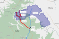
Red dots represent sensitive and disputed locations on the line of actual control (LAC) and tri-junction areas.[1][2] Yellow dots represent Chinese claims in Nepal[3][4] and Bhutan[5]. These claims may or may not be officially recognized. Blue dots represent India Nepal territorial issues.
For the eastern section of the LAC i've have copied the labels from the map I created currently placed in Sino-Indian border dispute. This intends to replace that one. (However what would be the point of adding the yellow and blue dots then). I should also shift this to a template (Template:Map of IN N NE border) before placing it in the article; touches up of course too. DTM (talk) 13:13, 15 June 2021 (UTC)
Namcha Barwa (AMS, 1954)
Reply - It depends on where this map is supposed to go. If it is supposed to represent Sino-Indian border disputes, then the blue dots don't belong. Also the disputes between Nepal and China don't belong here. I like the yellow dots for Doklam and Sakteng, because they are related to the Sino-Indian border dispute. Of course, Bhutan has tons more disputes with them, which we shouldn't cover here. (And nobody knows the full extent of them anyway.) -- Kautilya3 (talk) 13:31, 15 June 2021 (UTC)
Comment - Dibang Valley is the name of a district (two districts actually – Upper and Lower). We need something more refined to pinpoint the location. How about "Emra watershed"? I will make a redirect for Emra River. -- Kautilya3 (talk) 13:47, 15 June 2021 (UTC)
The Emra watershed was "unexplored" even until independence, and possibly for several decades after that. -- Kautilya3 (talk) 18:09, 15 June 2021 (UTC)
I started out at Emra River rather than the watershed. However I do see the watershed article in the making if there are other expeditions/treks into the area that recorded their journeys. DTM (talk) 07:34, 17 June 2021 (UTC)
The maps look beautiful, especially the one on the left. Good start on Emra River too. I am working through a little OSM map in my sandbox. But that is supposed to mark all the rivers and passes we know.
Meanwhile here is a nice twitter thread on the lakes [5]. Please see if we need to revise the names of the lakes. -- Kautilya3 (talk) 20:24, 17 June 2021 (UTC)
Thank you! Talking of "little OSM map", I remember you reduced the label sizes of the OSM map placed in Jaggang; light bulb in terms of map output. Though I still haven't decided on a standard set of label sizes as yet.
As for Dibang and the names of lakes, or even passes, I still haven't quite understood where most of names in the area are coming from apart from those eponymously named. Sources are scattered wider than most previous searches— Zikyen La (commons), Andra La (commons), Yangyap La/Yonggyap La (commons, osm), Athu popu/Kayala Pass (wikimapia, web), Inyi-Shamrah Peak (wikimapia), Glai pass(Glei pass) (osm), Galinggong (osm), Keya pass....
The best sources with collated information with regard to names/labels have been census and election maps for the district. DTM (talk) 10:38, 19 June 2021 (UTC)
Yeah, the Indian maps don't have anything about the lakes. Some Chinese hikers encroached there and went back and told everybody that there was a Garden of Eden on the other side of the border. It was apparently sensational. The twitter thread has a video somewhere at the top.
The reason I mentioned the twitter thread to you is that the Tibetan name is apparently "Nyam", which got corrupted to "Niangmu" in Chinese transliteration and the OSM editors seem to have misspelt it as "Nangmu". We should go back and call it "Nyam". -- Kautilya3 (talk) 20:21, 19 June 2021 (UTC)
The other problem here is that most Indian maps were wrong until recently. If you look in the census handbook map, the jut out where the lakes are present is missing. This gave some OSM editor the bright idea that India is claiming territory beyond the McMahon Line. But the McMahon Line clearly shows a watershed border (unlike Tawang and Migyitun, which are special cases). So, I am planning to delete that line.
Meanwhile, here is for your reading pleasure. We haven't been told where the six "disputed" and four "sensitive" areas are. But I expect the Zabu La is one of them because the watershed isn't easy to figure out. -- Kautilya3 (talk) 20:58, 19 June 2021 (UTC)
TOI (Sept 2020) talks about and names six disputed areas and four sensitive ones. link. DTM (talk) 10:50, 24 June 2021 (UTC)
So, there is nothing in the Debang Valley other than the Fishtail? I suppose this is how the newspeople dump irrelevant tidbits to make it look like they know something! -- Kautilya3 (talk) 11:42, 24 June 2021 (UTC)
Bringing the area in question (Zabu La) a little closer. (Though I have focused on Nyam rather than the pass). DTM (talk) 19:13, 24 June 2021 (UTC)
Talking of "most Indian maps were wrong until recently"... here is a BJP MP Tapir Gao raising the issue in Lok Sabha in Feb 2020.[6][7]
State Lok Sabha MP Tapir Gao has urged the Centre to redraw the State’s political map to include Angie Valley of Anini besides, Drai Calley, Kajab and Kayo Valleys of Chaglagam area in Anjaw district. [...] more than 120 kilometres have been carved out by the Survey of India and British India in mentioned areas of the State's eastern boundary with China. "More than 120 kilometres had been carved out by Survey of India in Angie Valley-Fish Tail-1(FT-1) in Dibang Valley district. Also in Fish Tail-2 (FT-2), like Drai Valley, Kajab Valley and Kayo Valley of Chaglagam areas in Anjaw district" said Gao. "Hadigra Dakahru Pass, Galai Tagaru Pass and Tatu Pass in Chaglagam areas are on top of the hill and all border outposts (BoPs) exist outside the drawn map. The political map should be redrawn including all these areas as per the Line of Actual Control (LAC) and Watershed Policy"
From both the Diplomat, TOI articles and Tapir Gao's statements as well as yours, we can say one thing, there are many areas in this region which are not publicly outlined properly. Zabu La is part of this at the moment. DTM (talk) 10:50, 24 June 2021 (UTC)
Bhai log,
1. You can file a suggestion on PM portal to correct these maps and instruct ASI to quietly NOTIFY new maps. Following style works best "To ensure prompt execution, ASI must assign it to a director level or above rank as nodal officer. ASI must notify these changes within 1 month and send a compliance report to PMO 2 days after that (1 month plus 2 days from now)." The trick is to (a) write the suggestion in a tone as if you are the PM (it will be copy paste forwarded to ASI) and (b) instruct a senior level rank to be in-charge (senior ownership with capability to make things happen), (c) put a deadline in your suggestion (urgency, and no delay), (d) ask for status report fed back to PMO (creates "I/PM will be watching you" type of fear in babus). This puts babus in high gear with sense of urgency and purpose. Some outsourced computer operate in PMO will read it, and forward to ASI, which will take it as PM's instruction. Babus are then good at following it blindly. Otherwise it never gets done, they delegate it to a lowly clerk, as no one takes ownership and they drown it in red tape of chain of approvals, etc. It works well if you are sending suggestions to PM and CMs, try it.
2. DTM, yes, you must include the Shakteng (and other areas in Bhutan) and Nepal's disputed area because they are part of the "context", which is also a "contiguous line along the Himalaya. Wiki guidelines are clear that article (and, hence, the corresponding map too) must be "self contained" and "standalone" and hence must capture the "context" too. Those articles which fail this criteria are tagged with the "context needed" tag and they never make it to the "good articles" list. Many of these bi-lateral disputes have neighbors tri-lateral and multi-lateral aspects too, e.g. Wakhan, Shaksgam, Siachen, Kalpeni, Doklam, Shaktang, China-Bhutan McMohan based settled IB, etc. Further more, India is building ICBR roads through Bhutan ("Nathu la - Doklam Road" is one of the ICBR). India is also proving aid for building ICBR type roads through Bhutan and Nepal which will negate India's Siliguri Chicken Neck Corridor vulnerability and provide India faster/alternative access to Tawang. Simply code these in 7 or more colors for the following: India vs China disputed sites, India vs Nepal, Bhutan vs China, China vs Nepal, China and Bhutan's settled McMohan border, China-Afghanistan disputed Wakhan Corridor which is tri-junction of India's claim and hence has implications for many nations, part of China-Tajikistan border contiguous to Wakhan (~60% China-Tajikistan border is disputed by China, you map could include only the part which sits next to Wakhan). Your map must include and "annotate" (a) the part of China-Myanamr border (closer to India border) settled on the basis of McMohan line, the very same line which China rejects with India. Then this map could be reused across multiple articles. Can't have bits and pieces of zigsaw puzzle type several maps which serve "siloed article" (which will not make it to "good articles" list). Having lesser number of comprehensive maps with better context and better reusability across multiple articles is a better practice. It reduces the effort/cost/investment in development and maintenance of the map. This principal in software engineering and "content management systems" is called the "encapsulation" (equivalent term in hardware engineering is plug-and-play "modular hardware") which delivers better ROI for your effort. Wikipedia is just an open-source content-management website.
58.182.176.169 (talk) 15:39, 15 July 2021 (UTC)
^Maj Gen (retd) Ashok K Mehta (28 May 2021). "Ladakh has lessons for India's China policy". The Telegraph. Retrieved 15 June 2021. Amish Mulmi, in his book All Roads Lead North (2021), mentions Chinese encroachment in September 2020 in Limi valley in Humla, which was confirmed by a Nepali lawmaker but denied by the government.
Hi Kautilya3 and DiplomatTesterMan, what is the name of river that flows entirely within south east part of Upper Dibang district from southwest corner of Fish Tail II (lower/southern Fish tail)'s to Etalin? It has at least 2 left bank and 1 right bank tributaries, their names? Thanks. 58.182.176.169 (talk) 15:17, 15 July 2021 (UTC)
The river that flows into Dibang from the east is called Tangon. It is not clearly marked on the Survey of India maps and I found OSM to be wrong as well. Since this is a key river basin between the two fishtails, I thought it important, and spent several hours fixing it. Here is the result. (You can also see the shapes directly on OSM, but you have to do more work to find the names.)
The Edza River got cut off unfortunately. It makes two 90-degree bends and contnues eastwards. The river that goes straight east is called the Chiane River. That is the one closest to Fishtail-II.
One thing we can see in the image is that Fishtail-II doesn't exist, in reality. The Tangon river basin to the north and the Delei river basin to the south interlock and there is no space left for any Tibet there. I have also taken the liberty to draw the watershed between the Indian rivers and the Tibetan rivers (in thin red), which goes straight through. No Fishtail. -- Kautilya3 (talk) 23:10, 15 July 2021 (UTC)
OSM battles
An amazingly good story on the OSM battles [6]. NM$L is now a public persona! -- Kautilya3 (talk) 11:57, 22 June 2021 (UTC)
Oh wow. That is indeed a good story. Now that I think about it I have never read stories related to OSM. DTM (talk) 13:48, 22 June 2021 (UTC)
OSM relations
I finally created my first relation on OSM; Nyam Lake (12873385), consisting of Deza Nyam Lake and Chong Nyam Lake. DTM (talk) 13:30, 22 June 2021 (UTC)
Cool! That is a difficult one to create because the two pieces were disconnected. In general, it is not recommended to do that. So, I added the stream in between to make it connected. -- Kautilya3 (talk) 23:01, 22 June 2021 (UTC)
Thanks for the above edit. Will keep this in mind.
I will spend some time on OSM so here is my to do list for now (based on this commons:File:Brahmaputra-river-basin.png). While I have written done, do point out any glaring errors or things I may have overlooked please.
Arunachal, major rivers and their basins
Arunachal Pradesh major rivers and their basins (OSM To Do)
Arunachal Pradesh major rivers and their basins (OSM To Do)
Wow, great work! -- Kautilya3 (talk) 11:06, 24 June 2021 (UTC)
Why is everything turning red? Blue is better for rivers! -- Kautilya3 (talk) 14:25, 28 June 2021 (UTC)
Kautilya3; When selecting 'relations' on OSM, the default is orange/red, for everything. I am yet to create the final version via umap. Those will be in blue. DTM (talk) 09:41, 1 July 2021 (UTC)
Bhai, please include the following in your To Do list. 1. Location of existing and planned dams (color code to differentiate the two), 2. Major bridges (color code to differentiate the following 4: road bridge vs rail bridge vs dual bridge vs tunnel). For example the district HQ Yingkiong has no bridge over the Siang river, and to go to Geling you have to go 70 km south to find a bridge and then back up, see here. though there is India's largest cable stayed footbridge (Gandhi Footbridge) opened there in 2019. 58.182.176.169 (talk) 16:50, 15 July 2021 (UTC)
Chottu, there are many online sources and books on UPSC exams or the concerned state's civil services exams. Their General Knowledge section has detailed info on the lists (sometimes with maps) of rivers, valleys, passes, etc, which I found useful in the past. Some of these might just be blogs, discussion boards, and obscure websites or youtube videos. These are good in providing basic info on topic that are hard to find in media. Once we know the exact topic, then we can search for sources on google scholar, online journal and databases (through online national library in your location or through university). After my PhD over, I no longer have access to university online journals databases for a long time. I still have online access to Singapore National Library, which has many eDatabases and eJournals including ProQuest, EBSCOhost, JSTOR and many more. I have not put it to use yet. If you want I can find a way to send you my id and pwd. Let me know. Once you read it, do not archive it, instead kind of delete it (edit it out). 58.182.176.169 (talk) 16:29, 15 July 2021 (UTC)
I like how you did the Bhai Chotu thing it was like a lightbulb when I got it... I will let you know about the journals and databases, thank you. Congrats on the completion of your PhD. DTM (talk) 10:14, 22 July 2021 (UTC)
Andrella Valley
The maps are looking great. But we need a way to mark these places [7]. -- Kautilya3 (talk) 19:16, 6 July 2021 (UTC) Amended link. -- Kautilya3 (talk) 16:29, 10 July 2021 (UTC)
Kautilya3; Mipi is sometimes in Nyingchi according to Google Maps; this would mean India administers Chinese territory in the same way Pakistan administers Indian territory.[Humor] Least of the mapping concerns on the horizon.[understatement]
Coming back to this part of Dibang Valley District; Mathun Valley is relatively well known, the district government has it on its official website. What would the lead spelling of Andrella Valley be? Andrella or Andrala?
Highlighted Andrala Valley and Mathun Valley in Mipi Circle, Dibang Valley District, Arunachal Pradesh. Via OSM Contributors.DTM (talk) 14:16, 10 July 2021 (UTC)
Yeah, most people on Twitter seem to think that "Andrella" is a corruption of "Andrala". But I see two problems with the theory.
One would call it "Andra valley" or "Andra river valley" rather than naming the valley on the pass at the head of it.
"Andra La" is marked as the border on the 1914 McMahon Line map. So there should be no confusion about where the border is (unlike the eastern border, which is quite confused).
Also one of the news reports said that it was to the "northeast" of Mipi. But, after considerable searching, I couldn't find anything resembling "Andrella" in the northeast. So we will probably have to go with Andrala.
What else do you think I could mark on this map? Mishmi Hills is one. Would marking some valleys, as discussed above Andrala and Mathun, make sense in this map? DTM (talk) 10:25, 15 July 2021 (UTC)
I could even put some elevation labels! DTM (talk) 11:43, 15 July 2021 (UTC)
DiplomatTesterMan, Well done and thanks for all the effort. From readers perspective the most of readership traffic will come from media reports if there is geostrategic flare up or construction of large infra there. Hence, please put the locations of major villages, posts, historical battle/caravan/expedition sites, proposed/existing infra (dam, bridge, tunnel, etc, e.g. for this area Arunachal Frontier Highway has been proposed which Kiren Rijju has been pushing for since 2014 and it roughly passes through circle HQs closest to LAC). 58.182.176.169 (talk)
I am happy with this image as is. Anything more will clutter it up. -- Kautilya3 (talk) 23:50, 15 July 2021 (UTC)
Kautilya3; thank you! Now that I have taken a breather, I think I can take up something I have wanted to do a quite some time, create a set of maps, same format, text, colours etc. Using this same scheme, I will try another district in Arunachal. DTM (talk) 09:54, 22 July 2021 (UTC)
As for Mr/Mrs IP...points have been noted. The Arunachal Frontier Highway, this is going to take decades... why not share roads with China? We drive through Tawang into China, use their roads, and then re-enter India at places such as Medog. DTM (talk) 09:54, 22 July 2021 (UTC)
That is great. One other idea. If you can figure out how to put geocoordinates on to them, then we can use them as locator maps. For example, try locating Hayuliang on the Lohit basin map. -- Kautilya3 (talk) 11:39, 22 July 2021 (UTC)
Wouldn't it be useful, in an encyclopedic sense, to create an OSM location map for McMahon's Line?— Template:McMahon LineDTM (talk) 07:33, 14 July 2021 (UTC)
No, not really. It would be too controversial, not to mention the practical impossibility of drawing the line at all. Note also that it is not clear what the "McMahon Line" means. India was using the 1935 Survey of India border, until China started contesting it. But even the 1935 bordre is still badly broken because it can't be related to land features. China supposedly wants to the 1914 line but feels free to violate it wherever it can. The whole thing is a mess. -- Kautilya3 (talk) 11:27, 14 July 2021 (UTC)
If not an OSM map, could something like this File:Aksai Chin Sino-Indian border map.svg be drawn up for Arunahcal area? Rather than actually wanting to create it just now, I was just wondering if it could even be drawn up. DTM (talk) 10:30, 15 July 2021 (UTC)
Overall messy, but not too messy if we break it down. Indo-China border is mix of mutually agreed IB (international border) and LAC which forms only part of the Indo-China border. Along the LAC, there are few known "more disputed than others" areas (e.g. Tawang). Those are the areas where there is bigger difference in perception of two nations compounded by the fact that McMohan line (drawn with thick pen on high scale map) on the map which tried to follow the principals of watershed, etc did not match with the real geography on the mao. If you break it down to smaller components, do sector/area specific maps first, then do a bottom up map, then it could work. if you stay on it for say next couple of years, you can slowly draw it up without downing yourself in it. For each sector you can have a map that shows, line how it ran on India's 1935 map vs line along the actual watershed (or any other) principal it was ought to follow vs china claim vs whatever-additional-parameters. You can use some other approach which works for you. I suggest, please start with India-China-Bhutan triangle in Tawang, see Dhola Post and my edit reverted by Kautilya which he says is incorrect - meanwhile you can make corrections to the edit if you know the area). There is no proper map and explanation of geography and locations. You are on to something which is much needed. Take your time and thanks in advance. 58.182.176.169 (talk) 17:28, 15 July 2021 (UTC)
Well, we have several lines here:
1914 line drawn by McMahon, and signed by British India and Tibet.
1935 line drawn by Survey of India and more or less adopted by independent India (except for the mess-up at Namka Chu and a really weird mess-up at Asaphila).
The de facto LAC that exists now.
The de facto LAC as seen by the US Geographer (which seems to follow the real watersheds, except for Tawang and Migyitun, where it is the 1914 line, and some pseudo-watershed for the two Fishtails).
All of these lines are subtly different. And there is no way to figure out which line to draw. Kyang Thang produced this image to compare the Survey of India's LAC and the US Geographer's LAC. They basically agree nowhere!
I personally think the US Geographer's line to be the best one and India + China should settle on that, at least for everything except Tawang and Longju. But it looks like we will need to fight a war before anything happens. -- Kautilya3 (talk) 23:47, 15 July 2021 (UTC)
Thank you both for the comments!! DTM (talk) 09:46, 22 July 2021 (UTC)
A piece of your new map made it Twitter this morning. [8] -- Kautilya3 (talk) 09:14, 27 July 2021 (UTC)
Kautilya3, while we mark passes on OSM location maps with a "point", passes are areas, sometimes covering significant distances. DTM (talk) 10:45, 9 August 2021 (UTC)
I'm trying to follow all these new names. They're not in the general Indian psyche and I doubt they should/will ever be. Is this the same as Shakche ALG that Indian media were covering?[1] (... not Shache Airport). Going by this list 'List of airports in China' we can create Tashkurgan Airport. I will go ahead and create it; confusions will probably sort themselves out. However it may be too soon since completion is next year. The map also needs additional labelsDTM (talk) 09:22, 22 July 2021 (UTC)
The ABP/ANI news leak is quite garbled. "Shakche" is obviously a misspelling of "Shache", which is a name of Yarkand. Tashkurgan is to the west. [9] I would expect that it is a real airbase for fighter/bomber operations, not an ALG (which would only be good for logistics). Similar elevation to Leh is obviously the military rationale. There are loads of hits for "Taashkurgan airport". -- Kautilya3 (talk) 11:04, 22 July 2021 (UTC)
By the way, Shache-Tashkurgan-Bolor was the traditional route into India. That is what Xuan Zhang etc. followed. Presumably that was also the route through which Kanishka invaded India (though it boggles my mind how horses could have managed those mountain tracks, which were said to be difficult even for mountaineers in the British times). It was only after the Caliphate came here and then withdrew that the region became too rowdy for travelers. Then it was advantage Ladakh. -- Kautilya3 (talk) 11:27, 22 July 2021 (UTC)
Kautilya3, you've written "boggles my mind how horses could have managed those mountain tracks".... Kyang Thang's would have less of a problem. However whenever they make statues or write the histories of past rulers, they never put them on mules or donkies or asses etc, always some "grander" animal like the horse or elephant or flying beast. Mules are much more studier for carrying loads across long distances in this terrain. Thang does indeed score.
Tashkurgan is located in such a dramatic area. While this area is familiar, my zoom level in the past has never consciously gone past 7 in OSM language. DTM (talk) 13:59, 23 July 2021 (UTC)
An invading Central Asian army would be nothing without horses. So the horses came, definitely, but by which route? I will have to look in Ahmad Hasan Dani sometime. -- Kautilya3 (talk) 16:48, 23 July 2021 (UTC)
"So the horses came, definitely, but by which route?"— I still haven't been able to shift my mind to this part of history. (edit: though the question is interesting) DTM (talk) 16:34, 31 July 2021 (UTC)
The full image on Commons has an "imagemap" highlighting all the destroyed buildings on the hill slope. I presume it was the result of the Cultural Revolution but nobody is saying. -- Kautilya3 (talk) 16:00, 26 July 2021 (UTC)
This is like those viral images "can you spot the animal".... "can you spot the ruins"...
Lonely Planet calls the "ruins" as "impressive". I wonder if the undestroyed buildings would have been called "impressive". This isn't to say ruins in general shouldn't be called impressive, such as the Colosseum, which we celebrate... searching "monasteries destroyed by china" on Google gives Larung Gar. Another Colosseum indeed. This article could do with some touching up too.
... with many historic sites having been rebuilt as static museums without any dynamic religious life within. They are also under increasing pressure to visibly and enthusiastically ally themselves to the party-state, and to redefine themselves as symbols of an imagined national identity that minimizes or excludes recognition of foreign influences and inspirations.1
Request for helping me in creating my wikipedia page
This is Kabra Altaf, a kashmir born indian judo player, i have been playing this sport from past 10 years and have won several national medals, titles, khelo india medals and have been part of india camps and other prestigious sports institutes of india.
I request you to help me in creating my wikipedia page! Ahleem altaf (talk) 16:29, 24 August 2021 (UTC)
Ahleem altaf, hi! There is a related draft article— Draft:Kabra Altaf. It was declined by an admin on 4 August 2021, "This submission's references do not show that the subject qualifies for a Wikipedia article—that is, they do not show significant coverage (not just passing mentions) about the subject...". Further " guidelines for sports persons and athletes" has to be considered.
So we have two basic points here,
Are there enough reliable references that cover Kabra Altaf significantly?
Does the article meet guidelines for sports notability?
I have gone through the references in the draft. I think it would not be possible to get this through Articles for Creation (AFC) at this stage. If you want to try resubmitting it after improvements, do go ahead. Remember that we are all volunteers here. These comments are my personal opinions.
There are some lines such as "the only athlete from Kashmir to win a medal in the Khelo India University Games 2020" which could find its way into Sports in Jammu and Kashmir under a section for "Khelo India" such as "Participation in Khelo India" which would combine JKs participation in the Khelo India Winter Games as well as the other Khelo India Games. But you should note that some of the content already on the page Sports in Jammu and Kashmir may not pass scrutiny. Even this addition to 'Sports in Jammu and Kashmir' will have to keep in mind guidelines and policies.
In short, being on Wikipedia in no big deal! If you aren't on it just now, it doesn't mean you don't exist or aren't doing quality work. If I think an article is clearly and legitimately possible as per Wikipedia policies and guidelines, I would have already created it without writing such a long reply. DTM (talk) 03:11, 26 August 2021 (UTC)
Maybe another attempt at the article can be made after a couple of months/years. DTM (talk) 03:34, 26 August 2021 (UTC)
Some frontier studies on youtube [10] and his web site https:theperspective.co.in. -- Kautilya3 (talk) 16:25, 31 August 2021 (UTC)
Thank you! DTM (talk) 08:26, 5 September 2021 (UTC)
The map labeling is really done nicely. I have to get around to labelling a 3D image, maybe of Pangong Tso, so then the 2D and 3D images can be considered together. DTM (talk) 10:13, 9 September 2021 (UTC)
WikiProject Military history coordinator election voting has commenced
Hey y'all, voting for the 2021 Wikiproject Military history coordinator tranche is now open. This is a simple approval vote; only "support" votes should be made. Project members should vote for any candidates they support by 23:59 (UTC) on 28 September 2021. Voting will be conducted at the 2021 tranche page itself. Appropriate questions for the candidates can also be asked. Thanks, MediaWiki message delivery (talk) 04:38, 15 September 2021 (UTC)
Yiku sitian, which you submitted to Articles for creation, has been created.
Congratulations, and thank you for helping expand the scope of Wikipedia! We hope you will continue making quality contributions.
The article has been assessed as Start-Class, which is recorded on its talk page. Most new articles start out as Stub-Class or Start-Class and then attain higher grades as they develop over time. You may like to take a look at the grading scheme to see how you can improve the article.
Since you have made at least 10 edits over more than four days, you can now create articles yourself without posting a request. However, you may continue submitting work to Articles for creation if you prefer.
If you have any questions, you are welcome to ask at the help desk. Once you have made at least 10 edits and had an account for at least four days, you will have the option to create articles yourself without posting a request to Articles for creation.
[11] Why did you remove these? This is exactly what 'See also' is meant for. Pieceofmetalwork (talk) 16:52, 20 September 2021 (UTC)
Pieceofmetalwork; MOS:ALSO says a couple of things in support for adding and for not including a see also section and links, as well as making a number of neutral statements.
Personally I have had a Wikipedia experience related to this, that is of adding a past death to a recent death in the see also section, where there is some sort of connection such as profession or method of death or nationality etc.
This was during the expansion of an article about a dead Baloch activist (where the counter article was Sajid Hussain (journalist)) and the subsequent ITN nomination. A comment by an editor (admin) "I'm more concerned about the, to my mind, unencyclopedic speculation over her cause of death." and the general reactions of Wikipedia editors (as evident by the article's history) stuck in my mind. Further, an editor removed my inclusion of the see also section in Hussain's article with this comment (edit link) removed section, WP:OR added by User:DiplomatTesterMan in Special:Diff/996051322, no WP:RS claim relation to Karima Baloch).
By mentioning this example I am not stating that what happened in that article with respect to the see also section can be generalised to other articles including the articles of the diplomats in question etc etc, what I am saying is that this example above was in my mind and influenced the decision. If you want to restore the see also section that is your "editorial" decision as per MOS:ALSO, however I feel biography rules also do not support the inclusion of this. DTM (talk) 06:43, 21 September 2021 (UTC)
Thank you for taking the time to explain. In this case both of these deaths were subject to some conspiracy theories, but the mainstream view was that they were natural deaths, as well as both being just after a quarantine period. Since we have to be a bit stricter on biographies, I agree to leave it out. There will probably be some news articles discussing both deaths that allow a short mention in the main body anyway. Pieceofmetalwork (talk) 07:20, 21 September 2021 (UTC)
Wikiproject Military history coordinator election voting period closing soon
FYI, today I cleaned up the outdated and very messy Naxalite–Maoist insurgency (LWE) as well as the corresponding Red corridor articles, see the article talkpage for the summary of changes. You might be interested in this new section I added - LWE infra projects - because it is similar to India-China Border Roads (ICBR) and it also falls within your area of interest "India's national security". There is scope for expansion, e.g. addition of new highways, railways, etc under construction, etc. Please feel free to directly edit/revise those articles. For now, I am done with these articles. Thank you and good night. 58.182.176.169 (talk) 15:18, 27 September 2021 (UTC)
I am not going to look at this page for now. Regard. DTM (talk) 06:40, 29 September 2021 (UTC)
Amit Shah should do some more footwork. DTM (talk) 06:48, 29 September 2021 (UTC)


 White's map; he travelled along Kyunka Chu/Charitang and crossed the mountain range at Kui La, leading to Demothang. The entire river was in Bhutanese territory according to him.
 AMS map from the 1950s; the topography is quite wrong, but the border crosses Amo Chu at the village called "Asam"; a little to the right of it is the Langmarpo and further to the right Kyanka river/Charitang.
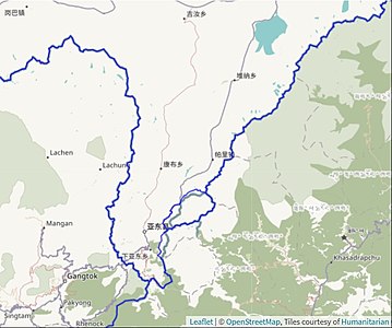 LSIB followed the watershed to the left Langmarpo whereas the borders in the OpenStreetMap run along Langmarpo.
.jpg)


 The Rambling Man, with 2963 points from three featured articles, 20 featured article reviews, 37 good articles, 73 good article reviews, as well as 22 DYKs.
 Epicgenius, with 1718 points from one featured article, 29 good articles, 16 DYKs and plenty of bonus points.
 Bloom6132, with 990 points from 13 DYKs and 64 "In the news" items, mostly recent deaths.
 Hog Farm, with 834 points from two featured articles, five good articles, 14 featured article reviews and 15 good article reviews.
 Gog the Mild, with 524 points from two featured articles and four featured article reviews.
 Lee Vilenski, with 501 points from one featured article, three good articles, six featured article reviews and 25 good article reviews.
 Sammi Brie, with 485 points from four good articles, eight good article reviews and 27 DYKs, on US radio and television stations.
 Ktin, with 436 points from four good articles, seven DYKs and 11 "In the news" items.
 Welcome, and thank you for your attempt to lighten up Wikipedia. However, this is an encyclopedia and articles are intended to be serious, so please don't make joke edits. Readers looking for accurate information will not find them amusing. If you'd like to experiment with editing, please use your sandbox instead, where you are given a certain degree of freedom in what you write. DTM (talk) 09:38, 22 July 2021 (UTC)

 Emra highlighted red
 Namcha Barwa range; Namcha Barwa Himal


.svg)


