Vassdalseggi
| Vassdalseggi | |
|---|---|
| Highest point | |
| Elevation | 1,658 m (5,440 ft) |
| Prominence | 510 m (1,670 ft) |
| Isolation | 12 km (7.5 mi) |
| Listing | 11 at List of highest points of Norwegian counties |
| Coordinates | 59°45′48″N 7°06′37″E / 59.7634°N 7.1104°E[1] |
| Geography | |
| Location | Rogaland and Telemark, Norway |
| Parent range | Ryfylkeheiane |
| Topo map | 1414 IV Haukelisæter and 1414 I Songavatnet |
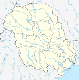
Vassdalseggi is the tallest mountain in Rogaland county, Norway. The 1,658-metre (5,440 ft) tall mountain sits on the border of the municipalities of Vinje (in Telemark county) and Suldal (in Rogaland county). Vassdalseggi lies in the Ryfylkeheiane mountains about 5 kilometres (3.1 mi) north of the mountain Fitjanuten and about 2.5 kilometres (1.6 mi) southeast of the mountain Kistenuten.[2]
See also[edit]
References[edit]
- ^ "Vassdalseggi, Suldal (Rogaland)" (in Norwegian). yr.no. Retrieved 2020-08-15.
- ^ Store norske leksikon. "Vassdalsegga" (in Norwegian). Retrieved 2015-05-21.


