
West DeLand Residential District
This article lacks inline citations besides NRIS, a database which provides minimal and sometimes ambiguous information. (November 2013) |
West DeLand Residential District | |
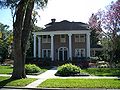
 House in district | |
 | |
| Location | DeLand, Florida |
|---|---|
| Coordinates | 29°1′57″N 81°18′37″W / 29.03250°N 81.31028°W |
| Area | 1,000 acres (4.0 km2) |
| NRHP reference No. | 92001617[1] |
| Added to NRHP | November 20, 1992 |
The West DeLand Residential District is a U.S. historic district in DeLand, Florida. It is bounded by University, Florida, New York and Orange Avenues, encompasses approximately 1,000 acres (400 ha), and contains 375 historic buildings. On November 20, 1992, it was added to the U.S. National Register of Historic Places.
References[edit]
External links[edit]
![]() Media related to West DeLand Residential District at Wikimedia Commons
Media related to West DeLand Residential District at Wikimedia Commons
Gallery[edit]
-
 House in district
 -
 House in district


This article about a property in Volusia County, Florida on the National Register of Historic Places is a stub. You can help Wikipedia by expanding it. |