Whakahoro
Whakahoro
Whakahoro | |
|---|---|
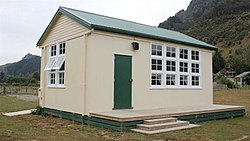
 Old Whakahoro School building, now run by DOC as a hut on the Whanganui Journey. | |
| Coordinates: 39°06′30″S 175°04′15″E / 39.10833°S 175.07083°E | |
| Country | New Zealand |
| Region | Manawatū-Whanganui |
| District | Ruapehu District |
| Ward | National Park |
Whakahoro is a small (now mostly empty) settlement located south of Taumarunui on the junction of the Retaruke and Whanganui Rivers,[1] about 104 mi (167 km) upstream from Whanganui.[2] By gravel roads it is 41 km (25 mi) west of Raurimu[3] and 44 km (27 mi) south west of Ōwhango.[4]
The settlement lies close to the northern edge of the Whanganui National Park in a rugged and largely inaccessible part of the country, connected to the national road network only via Oio Road, which links it to SH 4 via the townships of Retaruke and Kaitieke.[5] Whakahoro is located on Te Araroa, a major walking route which stretches the length of New Zealand and follows the Whanganui River for part of its length.[6] Tree planting has been done in the 21st century, but many sheep and wild pigs remain.[7]
The settlement's name is from Māori, and means "To break into pieces".[8]
Wade's Landing has made itself into various modern hand-held GPS databases, probably due to its historical nautical significance.
Today a bus tour includes Whakahoro,[9] or a jetboat can be chartered locally to take passengers up river to Taumarunui or down river to Pipiriki and Jerusalem.[10]
History[edit]


Historically, Whakahoro's Wade's Landing was a stopover point for riverboats steaming up and down the Whanganui River.[11] The landing was located just below Whakahoro at the confluence with the Retaruke River. Work on it started in 1913 and it was in use by 1914. It was here that wool from the Retaruke valley's sheep farms was originally freighted to Wanganui for eventual export.[12][13]
Improvements to navigation were gradually made. The first Hatrick launches reached the Retaruke in 1903.[14] In 1908 work started on more improvements.[15] A stone wall was built in 1920 to improve navigation on the river.[16] At that time Whakaoro was the name used for the west bank and Whakatara for the east bank settlement.[17]
Over the Whanganui River was the site of a Māori community. The land was subsequently leased to the Rusling family for sheep farming, but now has reverted to bush. The Roadway and Camp Road from here to the self-styled Republic of Whangamomona[18] are no longer maintained.
Just above the confluence is the former Lacy's hotel, which is now a farm house. It had its own separate landing, tennis courts, and in the 1920s locals would meet for a friendly game of Rugby union in their hobnail boots.
From 1927 there was a river boat semi-permanently anchored[19] at the junction.[20] This river boat served alcohol beverages. As the King Country was a dry area, such beverages were actually banned; the boat was considered "offshore" from the King Country.
A township with 16 sections was mapped in 1929.[21] Whakahoro had several streets, notably Lover's Lane and Dempsey Ave.
A school had been established by 1932.[22] In 1933 the teacher married local farmer, Frank Lacy.[23] The 1946 Whakahoro School building,[24] still stands, and has been converted into a stop over hostel for down-river canoeists.[25]
Lacy's Bridge crosses the Retaruke River at Whakahoro. This was built in 1932[26] to replace an earlier bridge built in 1915–16.[27]
The houseboat caught fire in 1933.[28]
See also[edit]
References[edit]
- ^ "Whakahoro, Manawatu-Wanganui". NZ Topo Map. Retrieved 1 July 2021.
- ^ "WANGANUI HERALD". paperspast.natlib.govt.nz. 17 May 1899. Retrieved 1 July 2021.
- ^ "Raurimu to Whakahoro". Google maps. Retrieved 1 July 2021.
- ^ "Ōwhango to Whakahoro". Google maps. Retrieved 1 July 2021.
- ^ McLintock, A.H. (ed.) (1959) A descriptive atlas of New Zealand. Wellington: NZ Government Printer. Map 3.
- ^ Te Araroa Trail 2020, map 55.
- ^ "Feature: Reinventing a remote area". NZ Herald. Retrieved 1 July 2021.
- ^ Wise's New Zealand guide (1969) Dunedin: H. Wise & Co. p. 408.
- ^ "Whio". Stray Travel. Retrieved 1 July 2021.
- ^ "Short Canoe Tours - Canoe the river today". whanganuirivercanoes. Retrieved 1 July 2021.
- ^ "Home". Blue Duck Station. Retrieved 1 July 2021.
- ^ "WANGANUI RIVER TRUST. WANGANUI CHRONICLE". paperspast.natlib.govt.nz. 24 October 1913. Retrieved 1 July 2021.
- ^ "WANGANUI RIVER. WANGANUI CHRONICLE". paperspast.natlib.govt.nz. 30 March 1914. Retrieved 1 July 2021.
- ^ "Wanganui River Trust. WANGANUI CHRONICLE". paperspast.natlib.govt.nz. 18 May 1903. Retrieved 1 July 2021.
- ^ "WANGANUI RIVER TRUST. WANGANUI CHRONICLE". paperspast.natlib.govt.nz. 7 March 1908. Retrieved 1 July 2021.
- ^ "WANGANUI RIVER. WANGANUI HERALD". paperspast.natlib.govt.nz. 23 March 1920. Retrieved 1 July 2021.
- ^ "1:63360 map Sheet: TN18". www.mapspast.org.nz. 1904. Retrieved 1 July 2021.
- ^ Whangamomona
- ^ "KAITIEKE COUNTY. SUN (AUCKLAND)". paperspast.natlib.govt.nz. 12 October 1927. Retrieved 1 July 2021.
- ^ "WANGANUI RIVER TRIP. AUCKLAND STAR". paperspast.natlib.govt.nz. 3 August 1927. Retrieved 1 July 2021.
- ^ "1:63360 map Sheet: WN7". www.mapspast.org.nz. 1929. Retrieved 1 July 2021.
- ^ "Wanganui Education Board. MANAWATU TIMES". paperspast.natlib.govt.nz. 17 November 1932. Retrieved 1 July 2021.
- ^ Tapp, Ethne (1 January 2000). "Memories of Whakahoro". Whanganui River annual, 2000; p.6-8; issn. Retrieved 1 July 2021.
- ^ "Schedule of Heritage Buildings and Sites" (PDF). Ruapehu District Plan. 1 October 2013.
- ^ "Whakahoro Bunkroom". www.doc.govt.nz. Retrieved 1 July 2021.
- ^ "Bridgemeister - 1932 Lacy's - Retaruke, New Zealand". www.bridgemeister.com. Retrieved 1 July 2021.
- ^ "Bridgemeister - 1920 Lacy's - New Zealand". www.bridgemeister.com. Retrieved 1 July 2021.
- ^ "HOUSEBOAT BURNT. EVENING POST". paperspast.natlib.govt.nz. 28 August 1933. Retrieved 1 July 2021.
