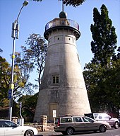
Wickham Park, Brisbane
| Wickham Park | |
|---|---|
 Wickham Park | |
 | |
| Location | Brisbane, Queensland, Australia |
| Area | 19,100 m2[1] |
| Operated by | Brisbane City Council[2] |
Wickham Park is a park at 330 Wickham Terrace, Spring Hill, Brisbane, Queensland, Australia.[2]
Geography[edit]
Wickham Park lies on the fall of the land from Wickham Terrace to down to Albert Street. To the north-west, it is adjacent to the Roma Street Parkland (formerly Albert Park) which lies on the fall of the land from the higher parts of Wickham Terrace down to the Roma Street railway station.[3]
History[edit]

Wickham Park was named after John Clements Wickham. It was formerly known as the Wickham Terrace Reserve and Wickham Terrace Park.
Heritage listings[edit]


Wickham Park contains a number of heritage-listed sites, including:
- 226 Wickham Terrace: The Old Windmill, the oldest surviving building in Brisbane[4]
- 230 Wickham Terrace: Spring Hill Reservoirs[5]
- 330 Wickham Terrace: Wickham Park Air Raid Shelters[6]
References[edit]
- ^ "Wickham Park". RikWare Pty Ltd. Retrieved 25 September 2014.
- ^ a b "Spring Hill parks". Brisbane City Council. Retrieved 6 July 2014.
- ^ "Wickham Park". Google Maps. Retrieved 27 January 2015.
- ^ "Windmill Tower (entry 600173)". Queensland Heritage Register. Queensland Heritage Council. Retrieved 19 June 2013.
- ^ "Service Reservoirs (entry 600174)". Queensland Heritage Register. Queensland Heritage Council. Retrieved 19 June 2013.
- ^ "Wickham Park Air Raid Shelters (entry 602476)". Queensland Heritage Register. Queensland Heritage Council. Retrieved 19 June 2013.
External links[edit]
![]() Media related to Wickham Park, Brisbane at Wikimedia Commons
Media related to Wickham Park, Brisbane at Wikimedia Commons
- "BRISBANE PARKS AND RESERVES". The Brisbane Courier. National Library of Australia. 13 July 1886. p. 5. — Description of the park in 1886
