
Wikipedia:Graphics Lab/Map workshop/Archive/Jul 2019
| This page is an archive. Do not edit the contents of this page. Please direct any additional comments to the current main page. |

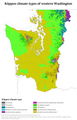
Washington climate map
-
 Old climate map
 -
 Non-climate map that you can use as a source for the new map


- Article(s)
- Western Washington
- Request
- If you zoom in on the old climate map, you'll see that it's weirdly pixellated; the climate coloring is applied in little blocks, which at some points "overflow" outside the state's borders, and which don't extend all the way to the state's borders in other places. Could you use the non-climate map (a nice SVG) as the basis for a new map (either SVG or PNG) depicting the same climate areas? Note that the area depicted on the climate map is identical to the red-highlighted areas on the other map. I'm well aware that the current climate map is very detailed, and I understand that this request might not be practical. Nyttend (talk) 23:11, 27 June 2019 (UTC)
- Discussion
- I don't think anything is wrong with that first map, the most detailed climate data available for the U.S. is calculated by 30 meter grid cells, so that's not pixelation due to image resolution, that's how the original data comes. So even though the border doesn't match exactly I think it's an accurate representation of the available data. Kmusser (talk) 17:40, 6 July 2019 (UTC)
A map for Climate emergency declaration

Hi! Does anyone could create a map to illustrate the article Climate emergency declaration?
We are thinking about a world map which shows what countries have declared the emergency. Any ideas? Thank you very much!--Javiermes (talk) 10:33, 6 July 2019 (UTC)
- @Javiermes:
 Done, feel free to improve the captions and description. --AntiCompositeNumber (talk) 01:40, 9 July 2019 (UTC)
Aztec city model
Hi. request to create a model of an Aztec city. Shaimosmos (talk) 20:10, 10 July 2019 (UTC)
Munster County Maps - 2014 Changes


- Article(s)
- Any article these maps already feature on.
- Request
- Okay, in accordance with the changes made to Ireland's local borders by the Irish Local Government Reform Act 2014, could the following alterations please be made to all of the above maps:
1) The removal of the former border between North Tipperary and South Tipperary, which were merged into a single entity of County Tipperary.
2) The removal of the former border of the Waterford City Council area, which was merged with the area covered by Waterford County Council to form a single entity under the name of Waterford City and County Council.
Thanks. Snow Lion Fenian (talk) 16:53, 17 July 2019 (UTC)
- Discussion
Harriet Tubman key locations
-
 Old low-res jpeg map
 -
 Blank SVG map to use as base
 -
 New map


- Article(s)
- Harriet Tubman
- Request
- The Harriet Tubman article on English Wikipedia will be featured on the main page in late September. It's in good shape, except for this old map that was created back in 2007 and looks terrible by current standards. Please recreate the map as an SVG. You can use a crop of the blank SVG map above as a start. -- Kaldari (talk) 18:14, 22 August 2019 (UTC)
- Discussion
{{resolved}}