
Wikipedia:Graphics Lab/Map workshop/Archive/Sep 2009
Stale[edit]
Resolved[edit]
King's Highway (Charleston to Boston)[edit]
-
 Map of the King's Highway (Charleston to Boston)
 -
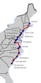 SVG map by TastyCakes
.jpg)

Article(s): King's Highway (Charleston to Boston)
Request: This very rough map was clipped from a pdf. I'd like to get a map for the article that is PD and have it loaded to the commons. See File:W-RSimpleMap.gif or File:BPR NY map.png for a similar map. Many thanks Philly jawn (talk) 17:54, 5 August 2009 (UTC)
Graphist opinion(s): I'd like to do this for you. How do I start? What does PD stand for? Rustbelt Maps (talk) 12:56, 24 August 2009 (UTC)
- I think it stands for Public Domain. TastyCakes (talk) 14:36, 24 August 2009 (UTC)
- Well I guess Rustbelt Maps has moved on, so I've made a map and put it up top and in the article. I'm not sure I've got the colours quite right and I'm not sure if the borders should appear over the route (in red), but here it is anyway. Also, Baltimore shows up on your sketch but not on the list in the article. I've left it in the map. TastyCakes (talk) 20:22, 28 August 2009 (UTC)
![]() Request taken by TastyCakes.
Request taken by TastyCakes.
- Thanks. Philly jawn (talk) 02:02, 29 August 2009 (UTC)
![]() Done
Done