
Eerbeek
Eerbeek | |
|---|---|
 Eerbeek, street view: de Stuijvenburchstraat | |
 Eerbeek Location in the province of Gelderland in the Netherlands  Eerbeek Eerbeek (Netherlands) | |
| Coordinates: 52°06′19″N 6°03′48″E / 52.10528°N 6.06333°E | |
| Country | Netherlands |
| Province | Gelderland |
| Municipality | Brummen |
| Area | |
| • Total | 17.08 km2 (6.59 sq mi) |
| Elevation | 20 m (70 ft) |
| Population (2021)[1] | |
| • Total | 9,845 |
| • Density | 580/km2 (1,500/sq mi) |
| Time zone | UTC+1 (CET) |
| • Summer (DST) | UTC+2 (CEST) |
| Postal code | 6961[1] |
| Dialing code | 0313 |
Eerbeek is a town in the municipality of Brummen in the province of Gelderland in the Netherlands. Eerbeek was first mentioned in 1046 as Erbeke. In the 18th century, Eerbeek became a centre of paper production. Due to its proximity to the Veluwezoom National Park, Eerbeek is popular with tourists.[3]
History[edit]
The village was first mentioned in 1046 as Erbeke. It is named after a stream, however the etymology is unclear.[4] Eerbeek developed near the spring of the Eerdbeek. In the 18th century it became a centre of paper production.[5]
Coldenhove Castle (Dutch: Kasteel Coldenhove) was a castle used as hunting lodge by the dukes of Guelders and the princes of Orange. Nothing remains anymore of the castle.
Huis te Eerbeek is a havezate (manor house) from the 14th century. It was rebuilt in neoclassic style in 1872, however one wing of its medieval predecessor has remained. It is surrounded by a large park, and is nowadays used as hotel and a conference centre.[5][6]
The water mill Oliemolen was built around and used to function both as an oil mill and a grist mill. A water mill was first referenced at the site in 1395. It remained in service until 1917. In 1967, the building was restored, however the grist mill part was modified into a restaurant.[7]
The Dutch Reformed church dates from 1930 and is a replacement of its 1857 predecessor. The tower which was built between 1858 and 1859 has remained and is detached from the church.[5]
Eerbeek was home to 747 people in 1840.[6] In 1887, a railway station was built on the Dieren to Apeldoorn railway line. It remained in service until 1950.[8] In 1975, it reopened as part of a museum line operated by the Veluwsche Stoomtrein Maatschappij.[5]
People from Eerbeek[edit]
- Jacob Emil van Hoogstraten, Director of the Department of Economic Affairs in colonial Indonesia
- Karel Aalbers, former chairman of football club Vitesse Arnhem
- Daan Huiskamp, football player
- Jan Mankes, painter
- Willem de Mérode, poet
- Edward Sturing, football player and coach
- Max Carl Wilhelm Weber, zoologist
- Robert de Haan, racing driver
Gallery[edit]
-
 Huis te Eerbeek
 -
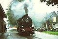 Train arriving in Eerbeek (1975)
 -
 Draw bridge
 -
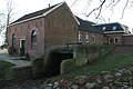 The water mill of Eerbeek
.jpg)


References[edit]
- ^ a b c "Kerncijfers wijken en buurten 2021". Central Bureau of Statistics. Retrieved 13 April 2022.
- ^ "Postcodetool for 6961AA". Actueel Hoogtebestand Nederland (in Dutch). Het Waterschapshuis. Retrieved 13 April 2022.
- ^ "Huis Te Eerbeek". Veluwe actief (in Dutch). Retrieved 13 April 2022.
- ^ "Eerbeek - (geografische naam)". Etymologiebank (in Dutch). Retrieved 13 April 2022.
- ^ a b c d Ronald Stenvert & Sabine Broekhoven (2000). "Eerbeek" (in Dutch). Zwolle: Waanders. p. 117. ISBN 90 400 9406 3. Retrieved 13 April 2022.
- ^ a b "Eerbeek". Plaatsengids (in Dutch). Retrieved 13 April 2022.
- ^ "watermolen". Molen database (in Dutch). Retrieved 13 April 2022.
- ^ "station Eerbeek". Stationsweb (in Dutch). Retrieved 13 April 2022.
External links[edit]
 Media related to Eerbeek at Wikimedia Commons
- Eerbeek's Info site (in Dutch)