Ntare School
| Ntare School | |
|---|---|
| Location | |
 | |
| , | |
| Information | |
| Type | Public Middle School and High School |
| Motto | Better your best |
| Established | 1956 |
| Headteacher | Rwampororo Saul [1] |
| Number of students | 900 (2006)[2] |
| Slogan | The Lion Roars |
| Athletics | Rugby, soccer, track, tennis, hockey, cricket, volleyball, basketball, table tennis |
| Website | Homepage |

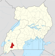
Ntare School is a residential all-boys' secondary school located in Mbarara, Mbarara District, south western Uganda. It was founded in 1956 by a Scottish educator named William Crichton.[3]
Location[edit]
The school is approximately 1 kilometre (0.62 mi), by road, north of the central business district of Mbarara,[4] the largest city (2014 population: 195,013),[5] in the Western Region. The school campus is approximately 267 kilometres (166 mi), by road, west of Kampala, Uganda's capital and largest city.[6] The coordinates of the school are 0°36'10.0"S, 30°39'11.0"E (Latitude:-0.602778; Longitude:30.653056).[7] The school is situated on the convex slope of Ntare hill at an elevation of 1,400 metres (4,600 ft), above sea level.[8]
Reputation[edit]
Ntare School is one of the most prestigious schools in Uganda due to its history, reputation, excellent academic performance, and dominance in sports.[9][10]
Ntare School also boasts of an Alumni Soccer League the Ntare Lions League[11] which runs every sunday.
Houses of residence[edit]
- Africa
- Nile
- Mbaguta
- Pioneer
- Aggrey
- New House
- Crichton
- Pearl
- Golden
Former Headmasters[edit]
Source:[13]
Mr. William Crichton - Founding Headmaster 1956 to 1971
Mr. Brian Remmer - 1971 to 1977
Mr. Jed Bangizi - 1977 to 1982
Mr. Gumisiriza G.L. - 1983 to 1985
Mr. H.H Mehangye - 1985 to 1987
Mr. Francis Kairagi - 1987 to 1990
Mr. Eric Kansiime - 1990 - 1991
Mr. Stephen Kamuhanda - 1991 to 2002
Mr. Humphrey Ahimbisibwe - 2003 to 2012
Mr. Turyagyenda Jimmy - 2013 up-2023
Mr. Rwampororo Saul- 2023- up to date
Notable alumni[edit]
Politicians[edit]
Academics[edit]
Judges[edit]
Lawyers[edit]
Writers[edit]
Others[edit]
- Allan Toniks
- Nashaba Victor - Information Technologist
- Bemanya Twebaze, Lawyer; former Registrar General Uganda Registration Services Bureau; Director General at Africa Regional Intellectual Property Organisation (ARIPO)
References[edit]
- ^ "Ntare School Students Engage Police In Running Battles". Red Pepper Uganda. 8 April 2013. Retrieved 3 April 2015.
- ^ "KayeSchools: Ntare School - The Lion Roars". Kayeschools.com. 2006. Retrieved 3 April 2015.
- ^ Nalubwama, Jackie (17 August 2006). "Ntare 'The Only' School: Laissez-Faire Attitude Pays Off". The Observer (Uganda). Archived from the original on 23 November 2006. Retrieved 3 April 2015.
- ^ "Map Showing Downtown Mbarara And Ntare School With Route Marker". Globefeed.com. Retrieved 3 April 2015.
- ^ "The Population of The Regions of the Republic of Uganda And All Cities And Towns of More Than 15,000 Inhabitants". Citypopulation.de Quoting Uganda Bureau of Statistics. 27 August 2014. Retrieved 3 April 2015.
- ^ "Road Distance Between Kampala And Ntare School With Map". Globefeed.com. Retrieved 3 April 2015.
- ^ "Location of Ntare School At Google Maps". Google Maps. Retrieved 3 April 2015.
- ^ "About Ntare School". Ntare School (NS). Retrieved 3 April 2015.
- ^ Talemwa, Moses; Mwesigye, Shifa (11 February 2010). "Top 10 Schools In Last 10 Years". The Observer (Uganda). Retrieved 3 April 2015.
- ^ Mubangizi, Michael (6 October 2009). "VIP Schools: Ntare And Kisubi OBs In Charge". The Observer (Uganda). Retrieved 3 April 2015.
- ^ Ntare Lions League
- ^ Accomodation [sic], Ntare School, accessed 16 April 2017
- ^ "Ntare School". Schoolsuganda. Retrieved 22 April 2019.
- ^ a b "President Museveni Attends Ntare School Alumni Reunion, Calls for Intellectualisation And Skilling of Society for Future Development". Statehouse.go.ug. 19 April 2014. Retrieved 3 April 2015.

