
Portal:Andes
The Andes Portal

The Andes (/ˈændiːz/ AN-deez), Andes Mountains or Andean Mountain Range (Spanish: Cordillera de los Andes; Quechua: Anti) are the longest continental mountain range in the world, forming a continuous highland along the western edge of South America. The range is 8,900 km (5,530 mi) long and 200 to 700 km (124 to 435 mi) wide (widest between 18°S and 20°S latitude) and has an average height of about 4,000 m (13,123 ft). The Andes extend from north to south through seven South American countries: Venezuela, Colombia, Ecuador, Peru, Bolivia, Chile and Argentina.
Along their length, the Andes are split into several ranges, separated by intermediate depressions. The Andes are the location of several high plateaus—some of which host major cities such as Quito, Bogotá, Cali, Arequipa, Medellín, Bucaramanga, Sucre, Mérida, El Alto and La Paz. The Altiplano Plateau is the world's second-highest after the Tibetan Plateau. These ranges are in turn grouped into three major divisions based on climate: the Tropical Andes, the Dry Andes, and the Wet Andes.
The Andes Mountains are the highest mountain range outside Asia. The highest mountain outside Asia, Argentina's Aconcagua, rises to an elevation of about 6,961 m (22,838 ft) above sea level. The peak of Chimborazo in the Ecuadorian Andes is farther from the Earth's center than any other location on the Earth's surface, due to the equatorial bulge resulting from the Earth's rotation. The world's highest volcanoes are in the Andes, including Ojos del Salado on the Chile-Argentina border, which rises to 6,893 m (22,615 ft). (Full article...)
Selected articles
-

Galeras (Urcunina among the 16th-century indigenous people) is an Andean stratovolcano in the Colombian department of Nariño, near the departmental capital Pasto. Its summit rises 4,276 metres (14,029 ft) above sea level. It has erupted frequently since the Spanish conquest, with its first historical eruption being recorded on December 7, 1580. A 1993 eruption killed nine people, including six scientists who had descended into the volcano's crater to sample gases and take gravity measurements in an attempt to be able to predict future eruptions. It is currently the most active volcano in Colombia. (Full article...) -
Cumbal is a stratovolcano of the Caribe Terrane, located at the Nudo de los Pastos in Nariño, Colombia. It is the southernmost historically active volcano of Colombia and is together with Chiles and Azufral one of the few volcanoes of the Western Ranges. The volcano is dominated by andesites. (Full article...) -
Azufral is a stratovolcano located in the department of Nariño in southern Colombia, 12 km (7 mi) west of the town of Túquerres. It is the only volcano of the Western Ranges of the Colombian Andes. Its name derives from the Spanish word for sulfur, azufre. The volcano is considered semi-dormant but there are numerous fumaroles in the summit crater. The summit of the volcano has an altitude of 4,070 metres (13,350 ft), and the north-western side of the crater contains a crescent-shaped lake named Laguna Verde (English: Green Lake) at 3,970 m (13,025 ft). The lake is 1,100 m (0.68 mi) long and 600 metres (2,000 ft) wide. and its bright green color is a result of the sulfur and iron-based deposits in the crater. There are also two other much smaller lakes in the crater, Laguna Negra (English: Black Lake) and Laguna Cristal (English: Crystal Lake).
The volcano lies within a nature reserve, the Reserva Natural del Azufral, created in 1990. The reserve covers an area of 5,800 hectares (58 km2) and is free of charge to enter. As Azufral is semi-dormant, there are no restrictions on ascending the volcano and visiting Laguna Verde: there is a road that climbs to within 1.5 kilometers (1 mi) from the summit, and the remaining distance can be covered on foot via a trail. (Full article...) -
Touching the Void is a 1988 book by Joe Simpson, recounting his and Simon Yates's near fatal descent after climbing the 6,344-metre (20,814 ft) peak Siula Grande in the Peruvian Andes. Approximately 15% of the book is written by Yates. It has sold over a million copies and has been translated into over 20 languages. (Full article...)
-
Lanín is an ice-clad, cone-shaped stratovolcano on the border of Argentina and Chile. It forms part of two national parks: Lanín in Argentina and Villarrica in Chile. As a part of the flag and anthem of the Argentine province of Neuquén, it serves as a symbol for the region. Although the date of its last eruption is not known, it is estimated to have occurred within the last 10,000 years. Following the 1906 Valparaíso earthquake a local newspaper reported the volcano to have erupted, but a work published in 1917 by Karl Sapper disputed this.
The ascent is regulated by the management of Argentine National Parks and the Argentine National Gendarmerie and is technically relatively simple but has a much higher level of exposure than the neighbouring volcanoes. The nearest towns, usually employed as a base for climbers, are Pucón in Chile and Junín de los Andes in Argentina. (Full article...) -
Patilla Pata is a stratovolcano in the Oruro Department in Bolivia. It is situated in the Sajama Province, in the west of the Curahuara de Carangas Municipality, at the border with Chile. Patilla Pata lies south-west of the mountain Jisk'a Kunturiri, north-east of the lake Q'asiri Quta (Khasiri Kkota) and the mountain Qullqi Warani, west of the little lake Sura Pata, south-east of the mountains Laram Q'awa, Kunturiri and Milluni and south of the little lake named Ch'iyar Quta.
The river Junt'uma K'uchu (Aymara junt'u warm, hot, uma water, k'uchu corner, "warm water corner", Junthuma Khuchu) originates south of Patilla Pata. It flows to the south-east as a right affluent of the Sajama River. (Full article...) -
Sangay (also known as Macas, Sanagay, or Sangai) is an active stratovolcano in central Ecuador. It exhibits mostly strombolian activity. Geologically, Sangay marks the southern boundary of the Northern Volcanic Zone, and its position straddling two major pieces of crust accounts for its high level of activity. Sangay's approximately 500,000-year-old history is one of instability; two previous versions of the mountain were destroyed in massive flank collapses, evidence of which still litters its surroundings today.
Due to its remoteness, Sangay hosts a significant biological community with fauna such as the mountain tapir, giant otter, Andean cock-of-the-rock and king vulture. Since 1979, its ecological community has been protected as part of the Sangay National Park. Although climbing the mountain is hampered by its remoteness, poor weather conditions, river flooding, and the danger of falling ejecta, the volcano is regularly climbed, a feat first achieved by Robert T. Moore in 1929. (Full article...) -

The llama (/ˈlɑːmə/; Spanish pronunciation: [ˈʎama] or [ˈʝama]) (Lama glama) is a domesticated South American camelid, widely used as a meat and pack animal by Andean cultures since the pre-Columbian era.
Llamas are social animals and live with others as a herd. Their wool is soft and contains only a small amount of lanolin. Llamas can learn simple tasks after a few repetitions. When using a pack, they can carry about 25 to 30% of their body weight for 8 to 13 km (5–8 miles). The name llama (in the past also spelled "lama" or "glama") was adopted by European settlers from native Peruvians. (Full article...) -
Monte Fitz Roy (also known as Cerro Chaltén, Cerro Fitz Roy, or simply Mount Fitz Roy) is a mountain in Patagonia, on the border between Argentina and Chile. It is located in the Southern Patagonian Ice Field, near El Chaltén village and Viedma Lake. It was first climbed in 1952 by French alpinists Lionel Terray and Guido Magnone. (Full article...) -
Lastarria is a 5,697 metres (18,691 ft) high stratovolcano that lies on the border between Chile and Argentina. It is remote, and the surroundings are uninhabited but can be reached through an unpaved road. The volcano is part of the Central Volcanic Zone, one of the four segments of the volcanic arc of the Andes. Over a thousand volcanoes—of which about 50 are active—lie in this over 1,500 kilometres (930 mi) long chain of volcanoes, which is generated by subduction of the Nazca Plate beneath the South American Plate.
The volcano is constituted by two volcanic edifices that form a ridge, and one subsidiary lava flow field southwest of the main volcanoes. The main edifice features several aligned craters that form a line. There is no recorded eruptive activity, but the volcano displays vigorous fumarolic activity on its northern side and within the craters. It is located on top of older volcanic rocks and features both andesite and dacite. (Full article...) -
Ancohuma or Janq'u Uma (Aymara janq'u white, uma water, "white water", also spelled Janq'uma, other spellings, Jankho Uma, Jankhouma) is the third highest mountain in Bolivia (after Sajama and Illimani). It is located in the northern section of the Cordillera Real, part of the Andes, east of Lake Titicaca. It lies just south of the slightly lower Illampu, near the town of Sorata.
Despite being higher than Illampu, Ancohuma is a gentler peak, with less local relief, and it is a somewhat easier climb. The peak was first climbed in 1919, by Rudolf Dienst and Adolf Schulze. Their route, still the easiest, climbs the southwest face, and is rated PD (not very difficult). Other routes exist on the northwest ridge and the west face. Depending on the route desired, the mountain is approached either from the west or from the northeast; each approach requires two to three days from Sorata. (Full article...) -
Pomerape is a stratovolcano lying on the border of northern Chile and Bolivia (Oruro Department, Sajama Province, Curahuara de Carangas Municipality). It is part of the Payachata complex of volcanoes, together with Parinacota Volcano to the south. The name "Payachata" means "twins" and refers to their appearance. It hosts glaciers down to elevations of 5,300–5,800 metres (17,400–19,000 ft), lower on the northern slope.
Pomerape is a complex of lava domes, accompanied by lava flows which were emplaced atop of the domes. It was active about 200,000 years ago. The lava domes formed first and were later buried by the actual volcanic cone, which unlike the rhyolitic-dacitic domes is formed by hornblende andesite. The "Chungará Andesites" and lava dome complex of Parinacota were laid down at this time. Pomerape is associated with an adventive vent that has erupted mafic magmas. The main cone was last active 106,000 +- 7,000 years ago, the adventive vent is dated to 205,000 ± 24,000 years ago. (Full article...) -
Illimani (Aymara and Spanish pronunciation: [iʎiˈmani]) is the highest mountain in the Cordillera Real (part of the Cordillera Oriental, a subrange of the Andes) of western Bolivia. It lies near the cities of El Alto and La Paz at the eastern edge of the Altiplano. It is the second highest peak in Bolivia, after Nevado Sajama, and the eighteenth highest peak in South America. The snow line lies at about 4,570 metres (15,000 ft) above sea level, and glaciers are found on the northern face at 4,983 m (16,350 ft). The mountain has four main peaks; the highest is the south summit, Nevado Illimani, which is a popular ascent for mountain climbers.
Geologically, Illimani is composed primarily of granodiorite, intruded during the Cenozoic era into the sedimentary rock, which forms the bulk of the Cordillera Real. (Full article...) -
The Sierra Nevada del Cocuy Chita or Guican National Natural Park (or Sierra Nevada de Chita or Sierra Nevada de Güicán, Spanish: Parque Natural Sierra Nevada del Cocuy Chita o Guican is a national park and a series of highlands and glaciated peaks located within the Cordillera Oriental mountain range in the Andes Mountains of Colombia, at its easternmost point. It also corresponds to the highest range of the Eastern Cordillera and holds the biggest glacial mass in South America, north of the Equator. Since 1977, this region is protected within a National Natural Park (NNP-Cocuy) because of its fragile páramos, extraordinary bio-diversity and endemism, and its function as a corridor for migratory species under conditions of climate change. Among the Sierra’s natural attractions are the remaining 18 ice-covered peaks (there were as many as 25 in the recent past), glacial lakes and waterfalls. (Full article...) -
Pico Humboldt is Venezuela's second highest peak, at 4,925 metres above sea level. It is located in the Sierra Nevada de Merida, in the Venezuelan Andes of (Mérida State). The peak, its sister peak Pico Bonpland, and the surrounding páramos are protected by the Sierra Nevada National Park. The mountain is named after German explorer and naturalist Alexander von Humboldt. (Full article...) -
The Llao Llao Hotel is located in the tourist resort of San Carlos de Bariloche within the Río Negro, Argentina.
This famous hotel is situated in the foothills of the Andes on a hill between the Moreno Lake and Nahuel Huapi lakes. (Full article...) -
Nevado del Huila (/nɛˈvɑːdoʊ dɛl ˈwiːlə/, Spanish pronunciation: [neˈβaðo ðel ˈwila]) at 5,364 metres (17,598 ft), is the highest volcano in Colombia, located at the tripoint of the departments of Huila, Tolima and Cauca. It is visible from the city of Cali. The andesitic volcano is located on top of the Ibagué Batholith.
After being dormant for more than 500 years, the volcano showed heavy signs of activity in 2007 and 2008. As of February 20, 2007, there were more than 7000 "minor" seismic events, and a high state of alert was in place for the departments of Cauca, Huila, Caldas and Valle del Cauca. The volcano erupted twice in April 2007, once in April 2008 and again in November 2008. Any eruption would affect the small villages around the volcano, mostly Páez, where their inhabitants still have in memory the eruption of the Nevado del Ruiz volcano and the destruction of Armero. (Full article...) -
Pico El León is a mountain in the Andes of Venezuela. It has a height of 4740 metres. (Full article...) -
Pichincha is a stratovolcano in Ecuador. The capital Quito wraps around its eastern slopes.
The two highest peaks of the mountain are Wawa Pichincha (Kichwa wawa child, baby / small, Spanish spelling Guagua Pichincha) (4,784 metres (15,696 ft)) and Ruku Pichincha (Kichwa ruku old person, Spanish Rucu Pichincha) (4,698 metres (15,413 ft)). The active caldera is in Wawa Pichincha on the western side of the mountain. (Full article...) -
Michincha is a stratovolcano on the border of Bolivia and Chile. It is part of an east–west trending ridge of stratovolcanoes. To its east lies Olca. The only historical activity from the complex was a flank eruption from 1865 to 1867. (Full article...)
-
Cerro Escorial is a stratovolcano at the border of Argentina and Chile. It is part of the Corrida de Cori volcanic group and its youngest member. A well-preserved 1-kilometre-wide (0.6 mi) crater forms its summit area. Lava flows are found on the Chilean and smaller ones on the Argentinian side, the former reaching as far as 3–4 kilometres (1.9–2.5 mi) from the volcano. One of these is dated 342,000 years ago by argon-argon dating.
Off the western coast of South America, the Nazca Plate subducts beneath the South America Plate. This process has given rise to the Andes mountain chain and the Altiplano-Puna high plateau, which formed through shortening of the crust that lasted until 1 million years ago. Cerro Escorial rises from the Puna, which is dissected at Cerro Escorial by the Archibarca lineament; it is a strike-slip fault that has facilitated the ascent of magma. (Full article...) -
Antisana is a stratovolcano of the northern Andes, in Ecuador. It is the fourth highest volcano in Ecuador, at 5,753 metres (18,875 ft), and is located 50 kilometres (31 mi) SE of the capital city of Quito.
Antisana presents one of the most challenging technical climbs in the Ecuadorian Andes. Next to the Pichincha, Cotopaxi, Tungurahua and Chimborazo, the Antisana belongs to the five volcanic mountains that the Prussian-born explorer Alexander von Humboldt tried to climb in 1802 during his American journey. (Full article...) -
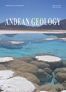
Andean Geology (formerly Revista Geológica de Chile) is a peer-reviewed scientific journal published three times per year by the National Geology and Mining Service, Chile's geology and mining agency. The journal covers the field of geology and related earth sciences, primarily on issues that are relevant to South America, Central America, and Antarctica with a particular focus on the Andes. The journal was established in 1974 and articles are published in English and Spanish. The editor-in-chief is Waldo Vivallo (National Geology and Mining Service). (Full article...) -
Nevado Juncal is a mountain at the border of Argentina and Chile, at the head of Aconcagua Val. It has a height of 5,953 metres (19,531 ft). It is located at La Yesera, Los Andes Department, Valparaíso Region, at the Central Andes. The mountain hosts several glaciers including the Juncal Norte and Juncal Sur. (Full article...) -
The vicuña (Lama vicugna) or vicuna (both /vɪˈkuːnjə/, very rarely spelled vicugna, its former genus name) is one of the two wild South American camelids, which live in the high alpine areas of the Andes, the other being the guanaco, which lives at lower elevations. Vicuñas are relatives of the llama, and are now believed to be the wild ancestor of domesticated alpacas, which are raised for their coats. Vicuñas produce small amounts of extremely fine wool, which is very expensive because the animal can only be shorn every three years and has to be caught from the wild. When knitted together, the product of the vicuña's wool is very soft and warm. The Inca valued vicuñas highly for their wool, and it was against the law for anyone but royalty to wear vicuña garments; today, the vicuña is the national animal of Peru and appears on the Peruvian coat of arms.
Both under the rule of the Inca and today, vicuñas have been protected by law, but they were heavily hunted in the intervening period. At the time they were declared endangered in 1974, only about 6,000 animals were left. Today, the vicuña population has recovered to about 350,000, and although conservation organizations have reduced its level of threat classification, they still call for active conservation programs to protect populations from poaching, habitat loss, and other threats. (Full article...)


.jpg)


.jpg)
.jpg)


Did you know...
- ... that the 1930s Polish Andean expeditions have been credited with several first ascents and the tracing of a new route to the summit of Aconcagua, the Andes' highest peak?
Need help?
Do you have a question about Andes that you can't find the answer to?
Consider asking it at the Wikipedia reference desk.
General images
-
 Central Andes (from Andes)
 -

-
 Laguna de Sonso tropical dry forest in Northern Andes (from Andes)
 -

-
 The seaward tilting of the sedimentary strata of Salto del Fraile Formation in Peru was caused by the Andean orogeny. (from Andean orogeny)
 -

-
 A male Andean cock-of-the-rock, a species found in humid Andean forests and the national bird of Peru (from Andes)
 -

-
 Pacha Mama Ceremony (from Andean agriculture)
 -
 Bolivian Andes (from Andes)
 -
 Paleogeography of the Late Cretaceous South America. Areas subject to the Andean orogeny are shown in light grey while the stable cratons are shown as grey squares. The sedimentary formations of Los Alamitos and La Colonia that formed in the Late Cretaceous are indicated. (from Andean orogeny)
 -
 Pico Humboldt at sunset (from Andes)
 -

-
 Syncline next to Nordenskjöld Lake in Torres del Paine National Park. The syncline formed during the Andean orogeny. (from Andean orogeny)
 -
 Map of the Andean region of South America (from Andean agriculture)
 -

-

-

-
 Frederic Edwin Church, Heart of the Andes, 1859. (from Andes)
 -
 View of Cuernos del Paine in Torres del Paine National Park, Chile (from Andes)
 -
 Nevado del Huila, Colombia (from Andes)
 -

-
 Parinacota, Bolivia/Chile (from Andes)
 -
 Irrigating land in the Peruvian Andes (from Andes)
 -
 Simplified sketch of the present-situation along most of the Andes (from Andean orogeny)
 -
 Map of a north-south sea-parallel pattern of rock ages in western Colombia. This pattern is a result of the Andean orogeny. (from Andean orogeny)
 -
 Topographic map of the Andes by the NASA. The southern and northern ends of the Andes are not shown. The Bolivian Orocline is visible as a bend in the coastline and the Andes lower half of the map. (from Andean orogeny)
 -

-
 Peruvian farmers sowing maize and beans (from Andes)
 -
 Aerial view of Valle Carbajal in the Tierra del Fuego. The Andes range is about 200 km (124 mi) wide throughout its length, except in the Bolivian flexure where it is about 640 kilometres (398 mi) wide. (from Andes)
 -

-
 Mashua tubers (from Andean agriculture)
 -
 Ulluco: Common crop of the Andean region (from Andean agriculture)

.jpg)


.jpg)


%E2%80%93Valle_Carbajal_01.jpg)

.JPG)
.jpg)
Subcategories

- Select [►] to view subcategories
Related portals
Subtopics
Associated Wikimedia
The following Wikimedia Foundation sister projects provide more on this subject:
-
 Commons
Free media repository -
 Wikibooks
Free textbooks and manuals -
 Wikidata
Free knowledge base -
 Wikinews
Free-content news -
 Wikiquote
Collection of quotations -
 Wikisource
Free-content library -
 Wikiversity
Free learning tools -
 Wiktionary
Dictionary and thesaurus


