
Portal:Western Australia
Introduction
 Western Australia (commonly abbreviated as WA) is a state of Australia occupying the western third of the land area of Australia, excluding external territories. It is bounded by the Indian Ocean to the north and west, the Southern Ocean to the south, the Northern Territory to the north-east, and South Australia to the south-east. Western Australia is Australia's largest state, with a total land area of 2,527,013 square kilometres (975,685 sq mi). It is the second-largest country subdivision in the world, surpassed only by Russia's Sakha Republic. the state has 2.76 million inhabitants—11 percent of the national total. The vast majority (92 percent) live in the south-west corner; 79 percent of the population lives in the Perth area, leaving the remainder of the state sparsely populated. The first Europeans to visit Western Australia belonged to the Dutch Dirk Hartog expedition, who visited the Western Australian coast in 1616. The first permanent European colony in what is today Western Australia occurred following the landing by Major Edmund Lockyer on 26 December 1826 of an expedition on behalf of the New South Wales colonial government.[text–source integrity?] Lockyer established a convict-supported military garrison at King George III Sound, at present-day Albany, and on 21 January 1827 he formally took possession for the British Crown of the western part of the continent that was not already claimed by the Crown. This was followed by the establishment of the Swan River Colony in 1829, including the site of the present-day capital, Perth. (Full article...)
|


.JPG)


(Northern
Territory) |
 Good articles -
-


Henry Daglish (18 November 1866 – 16 August 1920) was an Australian politician who was the sixth premier of Western Australia and the first from the Labor Party, serving from 10 August 1904 to 25 August 1905. Daglish was born in Ballarat, Victoria, and studied at the University of Melbourne. In 1882, he worked as a mechanical engineer but soon switched to working in the Victorian public service. He first stood for election in 1896 but failed to win the Victorian Legislative Assembly seat of Melbourne South. He then moved to Subiaco, Western Australia, where he found work as a chief clerk in the Western Australian Police Department. In 1900, Daglish was elected to the Subiaco Municipal Council and in April the following year, he was elected to the Western Australian Legislative Assembly as the member for the newly created seat of Subiaco, becoming one of six Labor members in the Western Australian Legislative Assembly. The party elected him as its whip, and he resigned from the Subiaco council on 1 May 1901. On 1 December 1902, Daglish was sworn in as mayor of Subiaco, having been elected the previous month.
In the 1904 state election, Labor won 22 of the Legislative Assembly's 50 seats, making it the party with the most seats. On 8 July 1904, the Labor Party caucus elected Daglish as the party's leader, and on 10 August, he successfully moved a motion of no confidence in the government of Walter James, who resigned as premier. Governor Frederick Bedford then swore in Daglish as premier of Western Australia, colonial treasurer and minister for education. His keynote speech on 23 August was poorly received; militant Labor supporters saw him as giving up on Labor policies. In parliament, Daglish struggled to achieve anything due to a hostile Legislative Council; his one major success was the passing of a new Public Service Act. In June 1905, a cabinet reshuffle decreased Daglish's popularity within the Labor Party but he defeated a motion of no confidence at a caucus meeting later that month. Daglish resigned as premier on 22 August 1905 when his plan to buy the Midland Railway Company for £1.5 million (equivalent to AU$126,500,000 in 2022) failed to pass through parliament. Hector Rason succeeded him as premier on 25 August. (Full article...) -
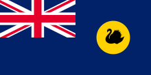
The flag of Western Australia consists of a Blue Ensign defaced with the badge of the state. Adopted in 1953 to replace a similar design used from the time when the state was still a British colony, it has been the flag of Western Australia since 3 November of that year. The design of the present flag entailed reversing the direction of the black swan so that it faced towards the hoist. This was done in order to adhere to vexillological convention. Western Australia's flag is similar to the flags of the other five Australian states, which are also Blue Ensigns with their respective state badges. When flown with those state flags and the national flag, it is sixth in the order of precedence. This is indicative of its position on the Commonwealth Coat of Arms. (Full article...) -
Severe Tropical Cyclone Fay was an intense late-season tropical cyclone which struck Western Australia during the 2003–04 Australian region cyclone season. Forming from an area of low pressure on 12 March, Fay was the only Category 5 cyclone during the season. The system had a minimum pressure of
910 mbar (hPa; 26.87 inHg) and maximum sustained winds of 210 km/h (130 mph). Moving towards the southwest and eventually towards the south, Fay gradually strengthened as it paralleled the northwestern coast of Australia, and made landfall on the Pilbara coast on the morning of 27 March as a Category 4 cyclone.
While no fatalities were reported, the cyclone brought record-breaking rainfall to Australia, which led to a sharp decrease in the country's gold output. The cyclone also caused minor damage in the Pilbara region of Western Australia. In the spring of 2005, the Australian Bureau of Meteorology retired the name Fay from use, and it will never be used again as a cyclone name. (Full article...) -
Victoria Park railway station is a suburban railway station on the Transperth network in Western Australia. The station is in the Perth suburbs of Lathlain and Victoria Park. Since November 2023, the station has been the terminus of the Armadale and Thornlie lines due to the Victoria Park-Canning Level Crossing Removal Project. The whole of each line is expected to reopen in mid-2025.
The first Victoria Park station opened in 1898 after lobbying by the Municipality of Victoria Park. It gained a station master in 1922, which lasted until 1969. The Victoria Park section of the Armadale line underwent several improvements in the 2000s. Lathlain station closed in 2003, and a nearby level crossing was removed and replaced with a bridge. The Thornlie line commenced services on 7 August 2005, enabling most Armadale services to skip the station. In 2007, construction started on a new Victoria Park station, 230 metres (750 ft) south of the original station and closer to the demolished Lathlain station. The new station had greater accessibility and was no longer on a curve, which allowed for a smaller platform gap. The new Victoria Park station opened on 2 August 2008, and the old one was demolished soon afterwards. (Full article...) -
Tropical Cyclone Herbie was the only known tropical system to impact Western Australia during the month of May on record. The final cyclone of the 1987–88 Australian region cyclone season, Herbie was first identified northwest of the Cocos Islands on 17 May. The following day, the system was classified as a tropical low by the Australian Bureau of Meteorology and intensified into a Category 1 cyclone later that day. Several hours after this upgrade, the storm attained its initial peak intensity with winds of 75 km/h (45 mph 10-minute sustained). Around the same time, the Joint Typhoon Warning Center classified Herbie as Tropical Storm 21S.
On 19 May, the cyclone formed a new low-pressure center and relocated roughly 300 km (190 mi) south. Shortly thereafter, the storm began to accelerate towards the southeast and started to undergo an extratropical transition. Early on 21 May, Herbie made landfall in Shark Bay before losing its identity the following day over the Great Australian Bight. Although a weak storm, Herbie brought flooding rains and severe dust storms to portions of Western Australia. Additionally, a 30,000 ton freighter broke in half amidst rough seas produced by the storm. Total losses from the storm reached A$20 million (US$15.6 million). Due to the significant damage wrought by Herbie, the name was retired following its use. (Full article...) -

Narrows Bridge
The Narrows Bridge is a freeway and railway crossing of the Swan River in Perth, Western Australia.
Made up of two road bridges and a railway bridge constructed at a part of the river known as the Narrows, located between Mill Point and Point Lewis, it connects the Mitchell and Kwinana Freeways, linking the city's northern and southern suburbs. The original road bridge was opened in 1959 and was the largest precast prestressed concrete bridge in the world. Construction of the northern interchange for this bridge necessitated the reclamation of a large amount of land from the river. (Full article...) -
Tropical Cyclone Alessia was the first tropical cyclone to affect the Northern Territory of Australia in November since Cyclone Joan in 1975. The storm was first identified as a tropical low on 20 November 2013 well to the northwest of Australia. Tracking generally west to west-southwest, the small system steadily organized into a tropical cyclone by 22 November. Maintaining a small central dense overcast, Alessia brushed the Kimberley region before making landfall in the Top End region with winds of 65 km/h (40 mph) on 23 and 24 November respectively. Some weakening took place as the system moved over land; however, reorganization occurred as it neared the Gulf of Carpentaria. After moving over water on 26 November, it redeveloped gale-force winds. Alessia reached its peak intensity on 27 November with winds of 85 km/h (53 mph) and a barometric pressure of 991 mbar (hPa; 29.26 inHg) and subsequently made its final landfall near Wollogorang. Weakening ensued once more as the storm traveled over land; though, Alessia's remnants looped eastward back over water before doubling back to the west. The system was last noted moving inland again over the Northern Territory on 1 December.
Throughout Alessia's existence, it caused only minimal damage. Several areas experienced gale-force winds, with gusts measured up to 109 km/h (68 mph) on Centre Island. Moderate to heavy rains accompanied the system as well, with a storm maxima of 290.4 mm (11.43 in) also occurring on Centre Island. (Full article...) -
Greenwood railway station is a park and ride suburban railway station in Perth, Western Australia, within the suburbs of Duncraig and Greenwood. The station is on the Joondalup line and is part of the Transperth network. Located within the median strip of the Mitchell Freeway at an interchange with Hepburn Avenue, Greenwood station consists of two side platforms connected to a car park east of the freeway by a footbridge.
The station was included within early plans for the Joondalup line in the 1980s, but the final plan for the Joondalup line, which opened in December 1992, did not include the construction of Greenwood station. After several promises by the state government during the 1990s to build the station, a A$6.8 million contract was awarded to John Holland Group in February 2004 to construct the station. Construction began in March 2004, and the station opened on 29 January 2005, relieving pressure on the car parks at Warwick and Whitfords stations. (Full article...) -
Severe Tropical Cyclone Ilona caused moderate damage across the Pilbara region of Western Australia in mid-December 1988. The system originated from a monsoon trough that coalesced into a tropical low over the Timor Sea on 12 December. The system initially moved southwest, before moving on a more westerly course. Steady intensification occurred and Ilona reached its peak strength on 17 December as a low-end severe tropical cyclone. A southward turn directed the cyclone toward Western Australia, and it made landfall near Mardie Station. The system subsequently degraded over land and dissipated on 19 December.
The cyclone's effects were relatively limited, though locally significant damage was reported in areas such as Dampier and Karratha. Several homes lost their roof and downed power lines left towns without power for several days. No casualties were reported, damage amounted to A$1 million (US$725,000), and the name Ilona was retired after the season. (Full article...) -
On 26 June 1950, a Douglas DC-4 Skymaster aircraft departed from Perth, Western Australia, for an eight-hour flight to Adelaide, South Australia. It crashed 22 minutes after take-off, 35 miles (56 km) east of Perth Airport. All 29 occupants were killed in the accident; one initially survived, but died six days later. It was the worst civil aviation accident in Australia.
As the aircraft flew eastwards over the outer suburbs of Perth numerous witnesses observed that it was flying at a lower altitude than usual for the daily Skymaster services, and at least one of the engines was running roughly and backfiring at regular intervals. In the minutes before it crashed, witnesses heard a number of different engine noises – sometimes operating normally, sometimes all engine noise ceased, only to be replaced by what was described as a very loud, high-pitched "scream". When the wrecked engines were examined many weeks after the accident a significant amount of corrosion product was found in the fuel system within two of the engines. After a preliminary investigation, Investigators from the Department of Civil Aviation believed the water responsible for the corrosion was also responsible for rough running of at least one engine, and ultimately temporary loss of power from all engines on at least one occasion. The investigators did not find a likely source for the water. (Full article...) -
The Thornlie line is a temporarily closed suburban railway line and service in Perth, Western Australia, operated by the Public Transport Authority as part of the Transperth system. The Thornlie line is a branch of the Armadale line which opened on 7 August 2005 and runs for 2.9 kilometres (1.8 mi) parallel to the Kwinana freight railway between the Armadale line at Kenwick and Thornlie station. Thornlie line services continued north of Kenwick along the Armadale line to Perth station, stopping at most stations, in contrast to Armadale line services, which skipped most stations along that section. The Thornlie line been suspended since 20 November 2023 due to construction work; it is planned to reopen in mid-2025.
The Thornlie line originated from initial plans for the Mandurah line, which was to branch off the Armadale line and run along the Kwinana freight railway. The Mandurah line's planned route changed in 2001, but not before tunnels were built for the line to exit the Armadale line at Kenwick and enter the Kwinana Freeway. It was decided to build the Thornlie line instead as a one station branch of the Armadale line. The main construction contract was awarded to Barclay Mowlem in 2004 and the Thornlie line opened on 7 August 2005. (Full article...) -
Seaforth railway station is a suburban railway station in Gosnells, a suburb of Perth, Western Australia. It is on the Armadale line which is part of the Transperth network, and is 22.6 kilometres (14.0 mi) southwest of Perth station and 7.8 kilometres (4.8 mi) north of Armadale station. The station opened on 4 May 1948 with low level platforms. High level platforms were added in 1968. The station consists of two side platforms with a pedestrian level crossing. It is not fully accessible due to steep ramps and a lack of tactile paving.
Services are operated by the Public Transport Authority. Peak services reach seven trains per hour in each direction, whilst off-peak services are four trains per hour. The station is one of the least used ones on the Transperth network, with just 136 boardings per day in October 2017. Since November 2023, the station has been temporarily closed for construction of the Victoria Park-Canning Level Crossing Removal Project and the Byford rail extension. (Full article...) -
Avondale Agricultural Research Station or Avondale Discovery Farm is one of thirteen research farms and stations operated by Western Australia's Department of Agriculture and Food. In addition to its research, Avondale has historical buildings, a farming equipment museum and operates as an agriculture education centre specialising in introducing primary school children to farming, and teaching of its history in Western Australia.
Avondale is situated on land where the Dale River joins the Avon River 10 kilometres (6.2 mi) northwest of Beverley. It is located on land originally granted to the first Governor of Western Australia, Captain (later Admiral Sir) James Stirling and Captain Mark Currie RN in 1836. These grants were combined in 1849 and with additional land purchases they became known as Avondale Estate, expanding to in excess of 13,330 acres (53.9 km2). (Full article...) -
Great Northern Highway is an Australian highway that links Western Australia's capital city Perth with its northernmost port, Wyndham. With a length of almost 3,200 kilometres (2,000 mi), it is the longest highway in Australia, with the majority included as part of the Perth Darwin National Highway. The highway, which travels through remote areas of the state, is constructed as a sealed, predominantly two-lane single carriageway, but with some single-lane bridges in the Kimberley. Economically, it provides vital access through the Wheatbelt and Mid West to the resource-rich regions of the Pilbara and Kimberley. In these areas, the key industries of mining, agriculture and pastoral stations, and tourism are all dependent on the highway.
In Perth, the highway begins in Midland near Great Eastern Highway, and further north intersects the Reid and Roe highways, which together form Perth's ring road. There are also three rural highways that spur off Great Northern Highway. Brand Highway and North West Coastal Highway provide an alternative coastal route between Muchea and Port Hedland, while Victoria Highway carries the National Highway route and interstate traffic into the Northern Territory. Various road routes are allocated to sections of Great Northern Highway, including the Highway 1 routes National Route 1 and National Highway 1, as well as National Highway 95. (Full article...) -
Maylands railway station is a suburban rail station in Maylands, a suburb of Perth, Western Australia. It is on the Midland line and Airport line, between Mount Lawley station and Meltham station. It is 4.5 kilometres (2.8 mi), or eight minutes by train, from Perth station. Services on each line run every 12 minutes during peak and every 15 minutes between peak for a combined frequency of a train every 6 minutes during peak and every 7.5 minutes outside peak.
A siding at the station's site opened in 1896; the station itself officially opened on 1 February 1900 with two side platforms. It was rebuilt as an island platform in the mid to late 1960s, as the Midland line was being converted from narrow gauge to dual gauge, which was not compatible with the side platforms. Maylands station underwent a refurbishment in 2001, in which disability access was improved and the station and surrounding area were beautified. (Full article...)


Did you know (auto-generated)

- ... that Bill Dunn, an Indigenous Australian pastoralist approaching retirement, sold his station at half-price to the Jigalong community despite receiving full-price offers from non-Indigenous people?
- ... that the search for a lost radioactive capsule along a 1,400-kilometre (870 mi) stretch of road in Western Australia was likened to looking for a needle in a haystack?
- ... that Western Australia was the second Australian state to legalise voluntary assisted dying?
- ... that politician John D'Orazio helped to secure a three-year trial of daylight saving time in Western Australia?
- ... that Nick Goiran, a member of the Western Australian Legislative Council, proposed 357 amendments to a voluntary assisted dying bill?
- ... that Mertome Village in Bayswater, Western Australia was the first aged care complex to be built by a local government in Australia?
Categories

More portals
More did you know...

- ...that when the 1987 America's Cup was raced off Fremantle, Western Australia it was the first time for 132 years that the regatta had not been hosted by the New York Yacht Club?
- ...that the original Victoria Dam, constructed in 1891, was the first dam in Western Australia, and it stood for almost 100 years before being replaced with the current dam?
- ...that Anglican bishop Kay Goldsworthy was consecrated as the first woman bishop of any Australian church on 22 May 2008?
Related WikiProjects

Things you can do
Here are some tasks you can do to help with WikiProject Western Australia:
Associated Wikimedia
The following Wikimedia Foundation sister projects provide more on this subject:
-
 Commons
Free media repository -
 Wikibooks
Free textbooks and manuals -
 Wikidata
Free knowledge base -
 Wikinews
Free-content news -
 Wikiquote
Collection of quotations -
 Wikisource
Free-content library -
 Wikispecies
Directory of species -
 Wikiversity
Free learning tools -
 Wikivoyage
Free travel guide -
 Wiktionary
Dictionary and thesaurus


