User:Abyssal/Portal:Cambrian
IntroductionThe Cambrian ( /ˈkæmbri.ən, ˈkeɪm-/ KAM-bree-ən, KAYM-; sometimes symbolized Ꞓ) is the first geological period of the Paleozoic Era, and of the Phanerozoic Eon. The Cambrian lasted 53.4 million years from the end of the preceding Ediacaran period 538.8 Ma (million years ago) to the beginning of the Ordovician Period 485.4 Ma. The Cambrian is unique in its unusually high proportion of lagerstätte sedimentary deposits, sites of exceptional preservation where "soft" parts of organisms are preserved as well as their more resistant shells. As a result, scientific understanding of the Cambrian biology surpasses that of some later periods. (Full article...) Selected natural world articleThe exposed geology of the Death Valley area presents a diverse and complex set of at least 23 formations of sedimentary units, two major gaps in the geologic record called unconformities, and at least one distinct set of related formations geologists call a group. The oldest rocks in the area are extensively metamorphosed by intense heat and pressure and are at least 1700 million years old. These rocks were intruded by a mass of granite 1400 Ma (million years ago) and later uplifted and exposed to nearly 500 million years of erosion. Marine deposition occurred 1200 to 800 Ma, creating thick sequences of conglomerate, mudstone, and carbonate rock topped by stromatolites, and possibly glacial deposits from the hypothesized Snowball Earth event. Rifting thinned huge roughly linear parts of the supercontinent Rodinia enough to allow sea water to invade and divide its landmass into component continents separated by narrow straits. A passive margin developed on the edges of these new seas in the Death Valley region. Carbonate banks formed on this part of the two margins only to be subsided as the continental crust thinned until it broke, giving birth to a new ocean basin. An accretion wedge of clastic sediment then started to accumulate at the base of the submerged precipice, entombing the region's first known fossils of complex life. These sandy mudflats gave way about 550 Ma to a carbonate platform which lasted for the next 300 million years of Paleozoic time. (see more...) Did you know...
Need help?Do you have a question about Abyssal/Portal:Cambrian that you can't find the answer to? Consider asking it at the Wikipedia reference desk. Selected image
Selected science, culture, and economics article
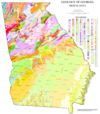
The geologic map of Georgia (a state within the United States) is a special-purpose map made to show geological features. Rock units or geologic strata are shown by colors or symbols to indicate where they are exposed at the surface. Structural features such as faults and shear zones are also shown. Since the first national geological map, in 1809, there have been numerous maps which included the geology of Georgia. The first Georgia specific geologic map was created in 1825. The most recent state-produced geologic map of Georgia, by the Georgia Department of Natural Resources is 1:500,000 scale, and was created in 1976 by the department's Georgia Geological Survey. It was generated from a base map produced by the United States Geological Survey. The state geologist and Director of the Geological Survey of Georgia was Sam M. Pickering, Jr. Since 1976, several geological maps of Georgia, featuring the state's five distinct geologic regions, have been produced by the federal government. (see more...)
TopicsEpochs - Terreneuvian - Cambrian Series 2 - Cambrian Series 3 - Furongian Geography - Pannotia - Baltica - Gondwanaland - Laurentia - Siberia Fossil sites - Walcott Quarry Researchers - Stephen Jay Gould - Simon Conway Morris - Charles Doolittle Walcott SubcategoriesQuality ContentFeatured Cambrian articles - None Things you can doRelated contentAssociated WikimediaThe following Wikimedia Foundation sister projects provide more on this subject:
|


