
Abuja
Abuja | |
|---|---|
 From top (L–R): View of a street in Maitama, Abuja National Mosque, Zuma Rock, fountain in Millennium Park, Central Bank headquarters, and nighttime skyline of the Central Business District | |
 Flag  Seal | |
| Nickname: ABJ | |
 Abuja Location of Abuja in Nigeria  Abuja Abuja (Africa) | |
| Coordinates: 9°4′N 7°29′E / 9.067°N 7.483°E | |
| Country | Nigeria |
| Territory | Federal Capital |
| Settled | 1828 |
| Incorporated | 1 October 1984 |
| Declared capital | 12 December 1991 |
| Government | |
| • Type | City management |
| • Body | Abuja Metropolitan Management Council |
| • Minister of the Federal Capital Territory | Nyesom Wike |
| Area | |
| • Federal capital city and local government area | 1,476 km2 (570 sq mi) |
| • Urban | 927 km2 (358 sq mi) |
| Elevation | 360 m (1,180 ft) |
| Population (2022 estimate)[1] | |
| • Federal capital city and local government area | 1,693,400 |
| • Rank | 7th |
| • Density | 1,100/km2 (3,000/sq mi) |
| • Urban | 3,770,000[3] |
| • Urban density | 4,066/km2 (10,530/sq mi) |
| • Metro | 6,000,000 (estimated)[2] |
| Time zone | UTC+01:00 (WAT) |
| Postal codes | 900211–900288 |
| Climate | Aw |
| Website | fcta |
 | |
Abuja (/əˈbuːdʒə/)[4] is the capital and eighth most populous city of Nigeria.[5] Situated in the middle of the country within the Federal Capital Territory (FCT), it is a planned city built mainly in the 1980s based on a master plan by International Planning Associates (IPA),[6][7][8] a consortium of three American planning and architecture firms made up of Wallace, Roberts, McHarg & Todd (WRMT – a group of architects) as the lead, Archi systems International (a subsidiary of the Howard Hughes Corporation), and Planning Research Corporation. The Central Business District of Abuja was designed by Japanese architect Kenzo Tange.[9][10][11] It replaced Lagos, the country's most populous city, as the capital on 12 December 1991.[12][13]
Abuja's geography is defined by Aso Rock, a 400-metre (1,300 ft) monolith left by water erosion. The Presidential Complex, National Assembly,[14] Supreme Court and much of the city extend to the south of the rock. Zuma Rock, a 792-metre (2,598 ft) monolith, lies just north of the city on the expressway to Kaduna.[15]
At the 2006 census, the city of Abuja had a population of 776,298[16] and 179,674 households[17] making it one of the ten most populous cities in Nigeria (placing eighth as of 2006). According to the United Nations, Abuja grew by 139.7% between 2000 and 2010, making it the fastest growing city in the world.[18] As of 2015[update], the city is experiencing an annual growth of at least 35%, retaining its position as the fastest-growing city on the African continent and one of the fastest-growing in the world.[19][20] As of 2016, the metropolitan area of Abuja is estimated at six million people, placing it behind only Lagos as the most populous metro area in Nigeria.[2][21][22]
Major religious sites include the Nigerian National Mosque and the Nigerian National Christian Centre. The city is served by the Nnamdi Azikiwe International Airport.[23][24][25] Abuja is known for being one of the few purpose-built capital cities in Africa, as well as being one of the wealthiest.[10]
Abuja is Nigeria's administrative and political capital. It is also a key capital on the African continent due to Nigeria's geo-political influence in regional affairs.[7] Abuja is also a conference centre and hosts various meetings annually, such as the 2003 Commonwealth Heads of Government meeting and the 2014 World Economic Forum (Africa) meetings.[7][26] Abuja joined the UNESCO Global Network of Learning Cities in 2016.
History[edit]


"Abuja" was in the earlier 20th century the name of the nearby town now called Suleja.[27]
The indigenous inhabitants of Abuja are the Basa, Gwandara, Gbagyi (Gwari) having the majority population in the region. Other groups in the area include the Gade, Dibo, Egburra, Nupe and Koro.[28]
The Gwandara speaking people in Abuja are mostly found in AMAC and Bwari Area Council. Some of their villages/settlements are Wuse, Asokoro now relocated to Sabon Wuse, Aso in Niger and other neighbouring states. Others are Karshi, Kurudu, Nyanya, Idu, Gwagwa, Jiwa, Sheretti, Karmo, Takunshara, Burum, Dutse Alhaji, Zuba, Kuje, Kwoi, Karon-Magaji, Ija, Kanwu, Sherre. [29] In light of the ethnic and religious divisions of Nigeria, plans had been devised since Nigeria's independence to have its capital in a place deemed neutral to all major ethnic parties, and also in close proximity to all the regions of Nigeria. The location was eventually designated in the centre of the country in the early 1970s as it signified neutrality and national unity.[30]
Another impetus for Abuja came because of Lagos' population boom that made that city overcrowded and conditions squalid.[31] As Lagos was already undergoing rapid economic development, the Nigerian regime felt the need to expand the economy towards the inner part of the country, and hence decided to move its capital to Abuja.[32] The logic used was similar to the way Brazil planned its capital, Brasília.
The Federal Military Government of Nigeria, promulgated decree No. 6 on 4 February 1976, which initiated the removal of the Federal Capital from Lagos to Abuja.[33][34] The initial work for Abuja's planning and implementation were carried out by the Military Government of General's Murtala Mohammed and Olusegun Obasanjo. However, the foundation of Abuja was under the Administration of Shehu Shagari in 1979.[33] Construction started in 1979 but, due to economic and political instability, the initial stages of the city were not complete until the late 1980s.[35]
The move of Nigeria's Capital to Abuja was controversial, and the biggest opposition to it was led by Obafemi Awolowo.[36] Awolowo, as a politician and a representative of the Yoruba people, defended their claims against the move of the Capital from Lagos. During the hotly-contested campaign for the presidency, he vowed to hire the American Walt Disney Company to convert the new site (Abuja) into an amusement park if he was elected.[36] However, after his election as president, Alhaji Shehu Shagari laid the first foundation for Abuja's infrastructure and pushed for its early completion. His first journey outside of Lagos after his election was to Abuja, where he visited contractors and workers on site to urge a speedy completion of the project. On his return, he confided in Alhaji Abubakar Koko his disappointment with the slow progress of work.[36] Shehu Shagari rescheduled the planned relocation to Abuja from 1986 to 1982 which later proved difficult.[37]
The International Planning Associates (IPA) was commissioned in June 1977, by the Federal Capital Development Authority (FCDA) to produce the Abuja Master Plan and its regional grid.[38] According to the terms of reference, the master planning process was to include a review of relevant data, selection of a capital city site, preparation of regional and city plans and the accompanying design and development standards manual.[39]
IPA did not exist prior to the Nigerian Government's engagement for an internationally reputable firm to design the master plan. IPA was formed by a consortium of three American firms which won the worldwide competitive bidding. The firms were Planning Research Corporation (PRC), Wallace, McHarg, Roberts and Todd, and Archisystems (a division of the Hughes Organisation). After winning the bid, and completing the project, the firms were disbanded.
The final report was submitted to the pioneer Executive Secretary of FCDA, Alhaji Abubakar Koko, on 15 February 1979. In the preface to the master plan, the following declaration was made by IPA:
"The master plan for Abuja the new Capital City of Nigeria represents the culmination of 18 months' work by the Federal Capital Development Authority (FCDA) board, several advisory panels consultants. Without the unstinting efforts of these experts, the momentum now exhibited at the beginning of the actual implementation of the new capital could not have been achieved. The plan itself represents a milestone in the process of building the new capital city. It is a necessary element in the monumental effort about to be undertaken by the Nigerian people."
The master plan for Abuja defined the general structure and major design elements of the city that are now visible. More detailed design of the central areas of the capital, particularly its monumental core, was accomplished by Japanese architect Kenzo Tange, with his team of city planners at Kenzo Tange and Urtec company.[40] Most countries relocated their embassies to Abuja, and many maintain their former embassies as consulates in Lagos, the commercial capital of Nigeria.[citation needed][41] Abuja is the headquarters of the Economic Community of West African States (ECOWAS) and the regional headquarters of OPEC. Abuja and the FCT have experienced huge population growth; it has been reported that some areas around Abuja have been growing at 20% to 30% per year.[42] Squatter settlements and towns have spread rapidly in and outside the city limits.[10][43] Tens of thousands of people have been evicted since former FCT minister Nasir Ahmad el-Rufai started a demolition campaign in 2003.[44][45]
Administration[edit]
The Abuja Municipal Area Council (AMAC) is the local government authority responsible for administering the city of Abuja. It operates under the oversight of the Federal Capital Territory Administration (FCTA), which governs the entire Federal Capital Territory (FCT). The AMAC's chairman is responsible for leading the council's activities and representing the interests of the municipality's residents.[46][47][48] The Minister of the FCT, Nyesom Wike[49], heads the FCTA while AMAC's chairman is Christopher Zaka Maikalangu.[50][51]
Phases[edit]


For ease and co-ordination of developmental efforts, the city was divided into 'Phases' by its planners, with the city's development taking a concentric form with Phase 1, which consists of the city's inner districts-Central Area, Maitama, Asokoro, Wuse, Wuse II, Garki, Garki II, Guzape and Guzape II-at its core spreading out from the foot of Aso Rock, while Phase 5, consisting of the newly created Kyami District covering the vicinity of the Nnamdi Azikiwe International Airport and the permanent campus of the University of Abuja, over 40 kilometres west of Aso Rock. Each Phase is separated from the other by an expressway (some still under construction); for example, Phases 1 and 2 are separated from each other by the Nnamdi Azikiwe expressway, while the entirety of the city proper (Phases 1–5) are enclosed by the Murtala Muhammed (Outer Northern-ONEX and Outer Southern-OSEX) expressways as well as the Federal A2 highway which traverses the Federal Capital Territory on its way to Kaduna (north-bound) and Lokoja (south-bound). Thus, there is an integration of the city's road network with the Federal highway network, providing access to the immediate outlying countryside and the surrounding states of the country i.e. Niger State to the west, Kaduna State to the north, Nasarawa State to the east and Kogi State to the south.[citation needed]
Abuja is organised into phases, which are further divided into districts.[52]
Phase 1[edit]
Asokoro District[edit]
Asokoro, the doyen of the districts, houses all of the state's lodges/guesthouses. The ECOWAS secretariat is a focal point of interest. Asokoro is to the east of Garki District and south of Central District. It is one of the most exclusive districts of Abuja and houses virtually all of the federal cabinet ministers as well as most of the diplomatic community in the city; in addition, the Presidential Palace (commonly referred to as the Aso Rock) is in Asokoro District. By virtue of this fact, Asokoro is the most secure area of the city.[53][54]
Central Business District[edit]
Abuja's Central District, also called Central Area, is a strip of land stretching from Aso Rock in the east to the National Stadium and the Old City gate in the West. It is like the city's spinal cord, dividing it into the northern sector with Maitama and Wuse, and the southern sector with Garki and Asokoro. While each district has its own clearly demarcated commercial and residential sectors, the Central District is the city's principal Business Zone, where practically all parastatals and multinational corporations have their offices. An attractive area in the Central District is the region known as the Three Arms Zone, so-called because it houses the administrative offices of the executive, legislative and judicial arms of the federal government. A few of the other sites worth seeing in the area are the federal secretariats alongside Shehu Shagari Way, Aso Hill, the Abuja Plant Nursery, Eagle Square (which has important historic significance, as it was in this grounds that the present democratic dispensation had its origin on 29 May 1999) and in which all subsequent Presidential Inauguration ceremonies have taken place. The Tomb of the Unknown Soldier is situated across Shehu Shagari Way facing Eagle Square. This section is usually closed to traffic during the annual Armed Forces Remembrance Day ceremonies that is observed on 15 January. The National Mosque and National Church of Nigeria are opposite each other on either side of Independence Avenue.[55] A well-known government office is the Ministry of Defense, colloquially nicknamed "Ship House".[56] Also located here is the yet-to-be-completed National Square, Millennium tower and Nigeria Cultural Centre multi-functional complex.
Garki District[edit]
The Garki District is the area in the southwest corner of the city, having the Central District to the north and the Asokoro District to the east. The district is subdivided into units called "Areas". Garki uses a distinctive naming convention of "Area" to refer to parts of Garki. These are designated as Areas 1 to 11. Garki II is used to differentiate the area from Garki Area 2. Visitors may find this system confusing.[57]
Garki is presently the principal business and administrative district of Abuja. Numerous buildings of interest are in this area. Some of them include the General Post Office, Abuja International Conference Centre along the busy Herbert Macaulay Way, Nicon Luxury Hotel (formally known as Abuja Sofitel Hotel and Le Meridian), Agura Hotel and Old Federal Secretariat Complex Buildings (Area 1). A new five-star hotel, Hawthorn Suites Abuja, is in Garki.[58]
Area 2 is mainly used for residential purposes, although a zoological garden, as well as a small shopping centre, are to be found here as well. Several banks and other commercial offices are located along Moshood Abiola Way in Area 7. The headquarters of the Nigerian Armed Forces – Army, Airforce and Navy – is located on Muhammadu Buhari Way in the Garki District.
The tallest building in this district is the Radio House located at the Area 11 sector, which houses the Federal Ministry of Information and Communications, the Federal Radio Corporation of Nigeria (FRCN) and Voice of Nigeria (VON). The Nigerian Television Authority (NTA) stations and corporate headquarters are also in Garki. The Federal Capital Development Authority (FCDA) which oversees and runs the Administration of the Federal Capital Territory has its offices in Garki.
The Office of the Minister of the Federal Capital Territory is in Area 11.[59] This is the location of the Federal Capital Development Authority and other administrative buildings. A popular sub-neighborhood here is found in the vicinity of Gimbiya street, because it has the unique characteristic of being a purely administrative zone on weekdays, while transforming purely into an entertainment zone on weeknights and weekends.[60]

Other places of note include the Cyprian Ekwensi Arts & Culture Centre and The Nigerian Police Mobile Force CID (Criminal Investigation Department) headquarters in Area 10. The Abuja Municipal Area Council, which is the local government administration has its headquarters in Area 10. The new United States Embassy is in the Diplomatic Zone which adjoins Garki.
Guzape District[edit]
Maitama District[edit]

Maitama District is to the north of the city, with the Wuse and Central Districts lying to its southwest and southeast respectively. This area is home to the top bracket sections of society and business, and has the reputation of being very exclusive and very expensive. Interesting buildings include the Transcorp Hilton Abuja,[61] Nigerian Communications Commission Headquarters (NCC), National Universities Commission (NUC), Soil Conservation Complex, and Independent National Electoral Commission (INEC). The British High Commission is located along Aguiyi Ironsi Way, in Maitama. Also, the Maitama District Hospital is another notable building in Maitama. Maitama District is home to many of the European and Asian embassies.
Maitama II[edit]
Maitama II District Cadastral Zone A10 is a new district created by the FCT administration of Muhammed Bello in 2018. Maitama 2 as it is unofficially called was created from Mpape hills, a suburb bothering Bwari and Maitama Districts of the FCT. Maitama II has a high net worth of individuals especially legislators as allottees, which makes it a destination for real estate investors who desire to secure the future today.
It is not very clear what the government plans for the district as not much has been said by government agents, but cadastral zoning A indicates the government has good plans for Maitama 2 to correct some errors in Maitama District.
It was learned that plots of land were revoked from allottees of Mpape district to create the new Maitama II District, although a compensation plan is underway to relocate the revoked allottees to another district the government intends to create. Fortunately, some developers of the Mpape district who have building plan approval and have started building maintain their plots and allocations and are covered in the Maitama II District layout. It is not clear though if a fresh allocation bearing Maitama II District has been issued to this set of allottees.
Notable landmarks of the Maitama 2 district are Jubilation Avenue, Mount Pleasant Haven and Hilltop Estate.
The district infrastructure is in top gear as the Federal Government had in the 2018 and 2019 budgets allocated about N1.3b for the engineering design of the district. Villages around the district are leaving in fear of demolition at any time with the information reaching them that government will commence the infrastructure project of Maitama II District.[62]
Wuse District[edit]
Wuse District is the northwestern part of the city, with the Maitama District to its north and the Central District to its south. The District is numbered Zones 1–6. The Wuse Market is Abuja's principal market. The second most important post office in the city is here. This district houses the Sheraton Hotel and Towers (Zone 4), Grand Ibro International hotel, the Federal Road Safety Corps Headquarters (Zone 3), Nigerian Customs Services Headquarters, Federal Civil Service Commission (Zone 3), National Agency for Food and Drugs Administration (NAFDAC) (Zone 7), Wuse General Hospital, and the Nigerian Tourism Development Corporation. Just as Garki District has Garki II, Wuse has Wuse II. This is distinct from Wuse Zone 2. Like other inner Abuja districts such as Asokoro or Garki there are very few large housing estates, instead, office buildings, mansions and apartment blocks are prominent features of the area.[63][64]
Phase 2[edit]
Phase 3[edit]
Phase 4[edit]
There are five suburban districts: Nyanya, Karu, Gwagwalada, Kubwa, and Jukwoyi. Along the Airport Road (Now Umaru Musa Yar'Adua Express Way) are clusters of satellite settlements, namely Lugbe, Chika, Kuchigworo and Pyakassa. Other satellite settlements are Idu (the main industrial zone), Mpape, Karimu, Gwagwa, Dei-Dei (housing the International Livestock market and also International Building materials market).[65]
Cityscape[edit]

The Abuja skyline is made up of mostly mid-range and a few tall buildings. Only recently have tall buildings begun to appear. Most of the buildings are modern, reflecting that it is a new city.
Plans were made to build skyscrapers such as the Millennium Tower which is partly completed as work has stalled for the last few years. This structure looms 170 metres (560 ft) above the city. The tower is part of a huge cultural development complex called the Nigeria National Complex including the Nigeria Cultural Centre, a 120,000 m2 (1,300,000 sq ft) structure dedicated to the art and culture of Nigeria. The Cultural Centre and the Millennium Tower have been designed by the Italian architect Manfredi Nicoletti.[66]
Landmarks include the Millennium Tower, the Central Bank of Nigeria headquarters, the Nigerian Presidential Complex, the Ship House, the National Stadium, which was the main venue of the 2003 All Africa Games and some games, including the final, of the 2009 FIFA Under-17 World Cup, National Mosque, the National Church, Aso Rock and Zuma Rock.[66]
Parks and open areas[edit]

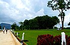
Abuja is home to several parks and green areas with the largest one being Millennium Park. Millennium Park was designed by architect Manfredi Nicoletti and was officially opened by the United Kingdom's Queen Elizabeth II (the former Queen of Nigeria) in December 2003. Another open area park is located in Lifecamp Gwarimpa; near the residence of the Minister of the Federal Capital Territory. The park is located on a slightly raised hilltop which contains sports facilities like Basketball and Badminton courts another park is the city park, it is located in wuse 2 and is home to numerous outdoor and indoor attractions such as a 4D cinema, Astro-turf, lawn tennis court, paintball arena and a variety of restaurants. The National Children's Park and Zoo host a number of animals, and recreation spots.[67]

Bush Bars[edit]
Abuja has a variety of informal spaces known as "Bush Bars" that usually, though not always, include a covered area with tables and chairs where people can sit and have drinks (alcoholic and non-alcoholic) and sometimes there are snacks such as suya, grilled catfish, pounded yam, egusi soup and other small items available for purchase. They are located all over Abuja.[68][69]
Geography[edit]
The elevation is 360 metres (1,180 ft).[70]

Climate[edit]
Abuja under Köppen climate classification features a tropical wet and dry climate (Köppen: Aw). The FCT experiences three weather conditions annually. This includes a warm, humid rainy season and a blistering dry season.[71] In between the two, there is a brief interlude of harmattan occasioned by the northeast trade wind, with the main feature of dust haze and cloudless skies.[citation needed][72]
The rainy season begins from April and ends in October,[73] when daytime temperatures reach 28 °C (82.4 °F) to 30 °C (86.0 °F) and nighttime lows hover around 22 °C (71.6 °F) to 23 °C (73.4 °F).[74] In the dry season, daytime temperatures can soar as high as 40 °C (104.0 °F) and overnight temperatures can dip to 15 °C (59.0 °F). Even the coolest nights can be followed by daytime temperatures well above 30 °C (86.0 °F).[74] The medium altitude and undulating terrain of the FCT act as a moderating influence on the weather of the territory. The city's inland location causes the diurnal temperature variation to be much larger than coastal cities with similar climates such as Lagos.[citation needed]
Rainfall in the FCT reflects the territory's location on the windward side of the Jos Plateau and the zone of rising air masses with the city receiving frequent rainfall during the rainy season from April to October every year.[75]
The effects of climate change have been observed in Abuja, according to a study conducted by the Nigerian Meteorological Agency and Atmospheric Science Group of Imo State University.[76] Between 1993 and 2013, the average maximum temperature trended downward, but the average minimum and mean temperatures trended upwards.[76] There was a downward trend for rainfall in Abuja, based on data collected between 1986 and 2016.[77][78] The drought occurrence probability for Abuja increased by 15.4% between 1975 and 2014.[79]
| Climate data for Abuja, Nigeria (1991-2020) | |||||||||||||
|---|---|---|---|---|---|---|---|---|---|---|---|---|---|
| Month | Jan | Feb | Mar | Apr | May | Jun | Jul | Aug | Sep | Oct | Nov | Dec | Year |
| Record high °C (°F) | 40.0 (104.0) |
42.0 (107.6) |
42.0 (107.6) |
41.0 (105.8) |
39.7 (103.5) |
37.8 (100.0) |
34.7 (94.5) |
33.5 (92.3) |
34.0 (93.2) |
40.0 (104.0) |
38.1 (100.6) |
39.0 (102.2) |
42.0 (107.6) |
| Mean daily maximum °C (°F) | 35.2 (95.4) |
36.9 (98.4) |
37.3 (99.1) |
35.6 (96.1) |
32.9 (91.2) |
30.8 (87.4) |
29.5 (85.1) |
28.7 (83.7) |
29.9 (85.8) |
31.3 (88.3) |
34.2 (93.6) |
35.0 (95.0) |
33.1 (91.6) |
| Daily mean °C (°F) | 26.9 (80.4) |
29.3 (84.7) |
30.7 (87.3) |
30.0 (86.0) |
28.1 (82.6) |
26.6 (79.9) |
25.7 (78.3) |
25.2 (77.4) |
25.7 (78.3) |
26.5 (79.7) |
26.9 (80.4) |
26.3 (79.3) |
27.3 (81.1) |
| Mean daily minimum °C (°F) | 18.5 (65.3) |
21.6 (70.9) |
24.1 (75.4) |
24.4 (75.9) |
23.3 (73.9) |
22.3 (72.1) |
22.0 (71.6) |
21.8 (71.2) |
21.6 (70.9) |
21.6 (70.9) |
19.7 (67.5) |
17.7 (63.9) |
21.5 (70.7) |
| Record low °C (°F) | 11.0 (51.8) |
13.7 (56.7) |
15.0 (59.0) |
14.0 (57.2) |
15.0 (59.0) |
17.2 (63.0) |
16.0 (60.8) |
15.0 (59.0) |
18.0 (64.4) |
16.5 (61.7) |
13.0 (55.4) |
8.9 (48.0) |
8.9 (48.0) |
| Average precipitation mm (inches) | 0.8 (0.03) |
5.9 (0.23) |
22.4 (0.88) |
72.8 (2.87) |
156.7 (6.17) |
194.4 (7.65) |
249.8 (9.83) |
308.3 (12.14) |
229.4 (9.03) |
169.5 (6.67) |
9.7 (0.38) |
1.3 (0.05) |
1,421.1 (55.95) |
| Average precipitation days (≥ 1 mm) | 0.1 | 0.4 | 1.9 | 6.0 | 11.3 | 12.2 | 15.0 | 17.3 | 16.0 | 13.0 | 0.9 | 0.0 | 94.0 |
| Average relative humidity (%) | 44.4 | 44.9 | 56.1 | 71.5 | 80.9 | 84.7 | 86.8 | 88.0 | 86.8 | 83.4 | 65.8 | 50.9 | 70.3 |
| Source: NOAA[80] | |||||||||||||
Environmental impact reduction[edit]
Vegetation[edit]
The FCT falls within the Guinean forest-savanna mosaic zone of the West African sub-region.[81] Patches of rain forest, however, occur in the Gwagwa plains, especially in the rugged terrain to the southeastern parts of the territory, where a landscape of gullies and rough terrain is found. These areas of the Federal Capital Territory (FCT) form one of the few surviving occurrences of the mature forest vegetation in Nigeria.
Gallery[edit]
-
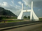 Abuja city gate
 -
 Zuma rock
 -
 Terminal at the Abuja International Airport
 -
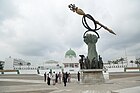 Nigeria's National Assembly Building with the Mace
 -
 The Ministry of Foreign Affairs
 -
 Shehu Musa Yar'adua Center
 -
 Glass Dome of Shehu Musa Yar'adua Centre in Abuja
 -
 Side view of Central Bank of Nigeria, Abuja
 -
 Usman Dam, Bwari Abuja
 -
 Nigeria Senate Building (Red Chamber)
 -
 Millennium Park
 -
 Abuja Millennium Park
 -
 Green hills
 -
 View of Abuja from Katampe hill


.jpg)


Demographics[edit]
At the 2006 census, the city of Abuja had a population of 776,298,[16] making it then the eighth most populous city in Nigeria. United Nations figures showed that Abuja grew by 139.7% between 2000 and 2010, making it the fastest growing city in the world.[18] As of 2015[update], the city is experiencing an annual growth of at least 35%, retaining its position as the fastest-growing city on the African continent and one of the fastest-growing in the world.[19]
Conurbation[edit]
Abuja has witnessed a huge influx of people into the city; the growth has led to the emergence of satellite towns, such as Karu Urban Area, Suleja, Gwagwalada, Lugbe, Kuje and smaller settlements towards which the planned city is sprawling. The urban agglomeration centred upon Abuja had a population estimated at 3,770,000 in 2022.[3] The metropolitan area of Abuja was estimated in 2016 at six million people, the country's second-most populous metro area.[2] The city has a large and growing immigrant community consisting mainly of nationals from the ECOWAS sub-region. The city has been undergoing a rapid pace of physical development over the last fifteen years.
Economy and infrastructure[edit]
Real estate[edit]
Real estate is a major driver of the Abuja economy. This correlates with the considerable growth and investment the city has seen as it has developed. The sources of this investment have been both foreign and local. The real estate sector continues to have a positive impact on the city, as it is a major avenue for employment.[82]
Annual trade fair[edit]
The Abuja International Trade Fair (AITF) has been held annually since 2005, under the auspices of Abuja Chamber of Commerce and Industry (ACCI).[83] ACCI has also sought to link businesses to enhance trade with East Africa.[84]
Postal system[edit]
Abuja is served by the Nigerian Postal Service (NIPOST) which maintains postal codes, street names and zones.[85][86]
Transportation[edit]
Airport[edit]
Nnamdi Azikiwe International Airport is the main airport serving Abuja and the surrounding capital region. It was named after Nigeria's first president, Nnamdi Azikiwe. The airport has international and domestic terminals.

Highways[edit]
Abuja is also linked to Nasarawa, Plateau, Benue and Northeast Nigeria by the A234 Federal Highway, which starts from the city as the Goodluck Jonathan expressway, some portions of which are still under construction. A direct highway link to Minna in Niger State is still under construction. The A2 expressway links Abuja with Kaduna in the north and Lokoja in the south. There are also other highway links with the outlying region, such as that linking the suburb of Dutse Alhaji with the Lower Usuma and Gurara Dams, which supply water to the city.[87]


Rail[edit]
Abuja is on the route of the planned Lagos–Kano Standard Gauge Railway, which has been completed between Abuja and Kaduna. Trains for Kaduna depart from the Idu Railway Station in Abuja. There is a car park at the train station for passengers traveling to the city centre.[88]
Abuja light rail system served between 2018 and 2020 and became the first rapid transit in the country and in Western Africa. - However, Abuja's light rail system was shut down in 2020, after less than 2 years of operation, due to the COVID epidemic and has not been restarted to date (July 2023). In 2023 the US$800 million costly Abuja light rail system has been called the "worst mass transit project in the world",[89] never managing to get more than 400 people a day to use it during its time of operation. Data analyst Tonami Playman described this as "abysmal". Comparable metro networks in the world typically transport several million people daily, even in other African countries like Cairo, Tunis, Addis Abeba and Algiers.[89] The COVID pandemic was reportedly a welcome excuse to end the unprofitable operation of the line.

Education[edit]
Abuja is also known as one of the states in Nigeria that provides quality post-secondary education. It is speedily becoming an attraction for students due to the growing presence of both public and private universities.[90]
Universities[edit]
- African University of Science and Technology[91]
- Baze University[92]
- National Open University of Nigeria[93]
- Nile University of Nigeria[94][95][96]
- University of Abuja[97]
- Veritas University[98][99]
- Philomath University[100]
International schools[edit]
- American International School of Abuja[101]
- Whiteplains British School, Jabi[102][103]
- École Française Marcel Pagnol
Natural resources[edit]
Abuja is one of the cities that are endowed with natural resources in Nigeria, and these resources serve as raw materials for pharmaceutical, food processing, medicinal and other processing companies, and they are also useful for commercial purposes, and as sources of food. Among these materials include:
Mineral Raw Materials[edit]
Agro Raw Materials[edit]
Honorary citizens[edit]
People awarded the Honorary citizenship of Abuja are:
| Date | Name | Notes |
|---|---|---|
| 10
February 2016 |
Joachim Gauck (24 January 1940–) | President of Germany(2012–2017)[4] |
| 4 July 2018 | Emmanuel Macron (21 December 1977–) | President of France (2017–).[107] |
| 30 August 2018 | Rt. Hon. Theresa May (1 October 1956–) | Prime Minister of the United Kingdom (2016–2019).[108] |
See also[edit]
References[edit]
- ^ a b "Federal Capital Territory (Nigeria)". City Population. Retrieved 29 October 2022.
- ^ a b c Jaiyeola, Andrews. "FCT Minister Harps on Development of Satellite Towns". Archived from the original on 6 August 2017. Retrieved 22 November 2016.
- ^ a b Demographia (July 2022). Demographia World Urban Areas (PDF) (18th ed.). Retrieved 3 November 2022.
- ^ a b "Define Abuja". Dictionary.com. Random House, Inc. Retrieved 14 April 2015.
- ^ "Abuja | Geography, Development, & Population". Britannica. Retrieved 12 March 2022.
- ^ Ogbuenyi, Nosike (3 February 2022). "Abuja at 46: The Dreams, Strides, Challenges". Premium Times Nigeria. Retrieved 7 November 2022.
- ^ a b c "The Nigeria Capital City". AMLSN National Conference. Archived from the original on 26 February 2022. Retrieved 7 November 2022.
- ^ Balogun, Ola (2001). The Federal capital territory of Nigeria: A Geography of its development. Ibadab: University of Ibadan Press.
- ^ "Central area of New Federal Capital City of Nigeria". Tange Associates. Retrieved 19 February 2022.
- ^ a b c "Life of poverty in Abuja's wealth". news.bbc.co.uk. BBC News, Tuesday, 13 February 2007. 13 February 2007. Retrieved 10 August 2007.
- ^ titel. "Build a house in Japan | Connect with Japanese Architects | titel". titel (タイテル). Retrieved 12 March 2022.
- ^ Roman Adrian Cybriwsky, Capital Cities around the World: An Encyclopedia of Geography, History, and Culture, ABC-CLIO, USA, 2013, p. 2
- ^ Alkasum, Abba (2012). ABUJA: The making of a capital city, 1976–2006.
- ^ "National Assembly | Federal Republic of Nigeria". www.nassnig.org. Retrieved 30 May 2020.
- ^ "Zuma Rock". Visit Nigeria Now. Archived from the original on 27 June 2022. Retrieved 4 January 2022.
- ^ a b "Legal Notice on Publication of 2006 Census Final Results" (PDF). Policy and Legal Advocacy Centre. Archived from the original (PDF) on 19 March 2013. Retrieved 10 June 2012.
- ^ Ogwueleka, Toochukwu Chibueze (1 August 2013). "Survey of household waste composition and quantities in Abuja, Nigeria". Resources, Conservation and Recycling. 77: 52–60. doi:10.1016/j.resconrec.2013.05.011. ISSN 0921-3449.
- ^ a b "World's Fastest Growing Cities are in Asia and Africa". Euromonitor. 2 March 2010. Archived from the original on 17 November 2015. Retrieved 26 October 2015.
- ^ a b "Top 5 Cities To Do Business in Nigeria. ABUJA Is 2nd". Abuja Facts. 22 April 2015. Archived from the original on 4 February 2016. Retrieved 26 October 2015.
- ^ Aguochi, O.J.J (2004). Abuja: Birth of the colossus. Stirling Horden publishers.
- ^ "Abuja Nigeria". ftan.org.ng. Archived from the original on 8 August 2021. Retrieved 30 May 2020.
- ^ Adam, Voiland (29 June 2022). "Building Abuja".
- ^ "Cheap Flights To Nnamdi Azikiwe International Airport – Travelstart.com.ng". www.travelstart.com.ng. Retrieved 7 November 2022.
- ^ "Abuja airport clocks 40, to begin parking service". Punch Newspapers. 28 September 2022. Retrieved 7 November 2022.
- ^ "Making Nigerian Airports W'Africa Regional Hub". www.thisdaylive.com. Retrieved 7 November 2022.
- ^ "Aso Rock Declaration on Development and Democracy: Partnership for Peace and Prosperity". The Commonwealth. December 2003. Archived from the original on 26 January 2022. Retrieved 30 May 2020.
- ^ "The New Federal Capital". Federal Capital Development Authority. 2018. Archived from the original on 19 May 2020. Retrieved 20 May 2018.
- ^ Barnabas, Sylvanus Gbendazhi (3 August 2018). "Abuja Peoples of Nigeria as Indigenous Peoples in International Law". International Journal on Minority and Group Rights. 25 (3): 431–457. doi:10.1163/15718115-02502002. ISSN 1385-4879. S2CID 150133231.
- ^ "Abuja". Office of the Auditor-General for the Federation. Archived from the original on 5 January 2022. Retrieved 5 January 2022.
- ^ "Abuja | Geography, Development, & Population". Britannica. Retrieved 5 January 2022.
- ^ Makinde, Adeyinka. "Abuja: Constructing Nigeria's Federal Capital | Ambitious Plans, Corrupt Practices | 1983". Youtube. Retrieved 6 September 2020.
- ^ Yusuf, Omotayo (1 October 2015). "#NigeriaAt55: Top 5 Reasons Nigeria's Capital Was Moved From Lagos To Abuja (PHOTOS)".
- ^ a b Moore, Jonathan (March 1984). "The Political History of Nigeria's New Capital". The Journal of Modern African Studies. 22 (1): 167–175. doi:10.1017/S0022278X00056846. JSTOR 160334. S2CID 154848195. Retrieved 23 September 2020.
- ^ Yusuf, Omotayo (1 October 2015). "Why The Capital Was Moved From Lagos To Abuja". Naija.ng – Nigeria news.
- ^ FCDA (1988). Abuja: The Making of new Capital city for Nigeria.
- ^ a b c Moore, Jonathan (March 1984). "The Political History of Nigeria's New Capital". The Journal of Modern African Studies. 22 (1): 173. doi:10.1017/S0022278X00056846. JSTOR 160334. S2CID 154848195. Retrieved 22 September 2020.
- ^ Moore, Jonathan (March 1984). "The Political History of Nigeria's New Capital". The Journal of Modern African Studies. 22 (1): 174. doi:10.1017/S0022278X00056846. JSTOR 160334. S2CID 154848195. Retrieved 22 September 2020.
- ^ Elleh, Nnamdi (2001). Abuja, the single most ambitious urban design project of the 20th century. VDG, Verlag und Datenbank für Geisteswissenschaften. ISBN 978-3-89739-165-9.
- ^ Shuaibu, Umar (16 March 2020). "Unsung heroes of Abuja master plan". Retrieved 22 September 2020.
- ^ Alkasum, Abba (2012). Abuja: The Making of a Capital City, 1976–2006.
- ^ "Nigeria's commercial capital, Lagos, shuts schools amid COVID-19". Reuters. Retrieved 11 February 2024.
- ^ "World Bank Conference: African Regional Roundtable on Upgrading Low-income Settlements" (PDF). citiesalliance.org. World Bank, 3–5 October 2000, Johannesburg, South Africa, p. 16. Archived from the original on 28 September 2007. Retrieved 10 August 2007.
- ^ "Resettlement Issues, Squatter Settlements and the Problems of Land Administration in Abuja, Nigeria's Federal Capital" (PDF). fig.net. 5th FIG Regional Conference Accra, Ghana, 8–11 March 2006. Retrieved 10 August 2007.
- ^ Polgreen, Lydia (13 December 2006). "In a Dream City, a Nightmare for the Common Man". nyt.com. New York Times, 13 December 2006. Retrieved 10 August 2007.
- ^ Ekoko, K.O (2006). El – Rufai and Abuja Urban renewal policies.
- ^ Olokesusi, Femi; Aiyegbajeje, Femi Ola; Arije, Ibitayo Modupe (2019), Vinod Kumar, T.M. (ed.), "Smart Metropolitan Regional Development of Abuja and Its Region", Smart Metropolitan Regional Development: Economic and Spatial Design Strategies, Singapore: Springer, pp. 797–825, doi:10.1007/978-981-10-8588-8_14, ISBN 978-981-10-8588-8, retrieved 23 April 2024
- ^ "ABUJA METROPOLITAN MANAGEMENT COUNCIL – Federal Capital Territory – FCT – Abuja – Nigeria". Retrieved 23 April 2024.
- ^ Federal Government of Nigeria (1991). Government's views on the Report of the Panel on the decree N0.6. 1976.
- ^ Ogbuenyi, Nosike (21 August 2023). "The significance of Wike's appointment as FCT minister, By Nosike Ogbuenyi". Premium Times Nigeria. Retrieved 26 August 2023.
- ^ Kwen, James (13 February 2022). "Abuja polls: PDP wins 3 chairmanship, APC gets two". Businessday NG. Retrieved 26 August 2023.
- ^ Abuchi, Joe (22 April 2024). "AMAC chairman pledges quick completion of Kugbo road". THE AUTHORITY NEWS. Retrieved 23 April 2024.
- ^ Galadima, Mukhtar (27 October 2022). "Population influx and Abuja's emerging districts". Daily Trust. Retrieved 23 April 2024.
- ^ "Asokoro Abuja | Area Guide". Villa Afrika Realty. Retrieved 23 April 2024.
- ^ Aga, Chiegeonu. Nigeria: State by State. Lulu.com. ISBN 978-1-105-86432-2.
- ^ "Independence Avenue". Wikimapia.org. 18 November 2012. Retrieved 30 August 2013.
- ^ "Ship House". Wikimapia.org. 18 November 2012. Retrieved 30 August 2013.
- ^ "Abuja City's Garki District - wtcf.travel". en.wtcf.org.cn. Retrieved 17 May 2023.
- ^ Cite error: The named reference
:22was invoked but never defined (see the help page). - ^ "Office of the Minister – FCT Residents Engagement Platform". Retrieved 17 May 2023.
- ^ "Abuja City Tour Guide". mmmHouse Abuja!. Retrieved 26 May 2020.
- ^ "Transcorp Hilton Abuja". Hilton Hotels and Resorts. Retrieved 23 April 2022.
- ^ "Maitama II Infrastructure to Commence Soon". leadership.ng. 29 May 2022.
- ^ "Geographical and Environmental Backgrounds of FCT, Abuja - Abuja OIPedia". 27 September 2017. Retrieved 17 May 2023.
- ^ "Here is what you need to know about Wuse; the commercial hub of Abuja". estateintel.com. Retrieved 17 May 2023.
- ^ "Abuja; The Capital City of Nigeria". Hintnaija. 23 June 2018. Retrieved 23 January 2021.
- ^ a b M.F.C.T (1995). Abuja: Achievements of the federal capital territory 1985–1992.
- ^ "23 things to do in Abuja". tripadvisor. Retrieved 23 September 2020.
- ^ Jeremy. "Sunday, August 27, 2006 Abuja bush bars". Archived from the original on 2 December 2013. Retrieved 22 November 2013.
- ^ "Nigerian Suya Recipe: For Nigerians in Diaspora". allnigerianrecipes.com. 2013.
- ^ "Abuja". Encyclopædia Britannica. Retrieved 27 January 2021.
- ^ "Climate: Abuja Federal Capital Territory, Nigeria". Worlddata.info. Retrieved 8 January 2022.
- ^ "nomadseason.com". Retrieved 11 February 2024.
- ^ "Average monthly rainfall and snow in Abuja, Nigeria (millimeter)". World Weather & Climate Information. Retrieved 8 January 2022.
- ^ a b "Abuja Climate, Weather By Month, Average Temperature (Nigeria) – Weather Spark". weatherspark.com. Retrieved 8 January 2022.
- ^ "Abuja Nigeria Tourist Information". Touristlink.com. Archived from the original on 24 March 2013. Retrieved 30 August 2013.
- ^ a b Orisakwe, Ikenna C.; Nwofor, Okey K.; Njoku, Clement C.; Ezedigboh, Ugochukwu O. (January 2017). "On the Analysis of the Changes in the Temperatures over Abuja, Nigeria". Journal of Physical Science and Environmental Studies. 3 (1): 9.
- ^ Itiowe, T.; Hassan, S. M.; Agidi, V. A. "Analysis of Rainfall Trends and Patterns in Abuja, Nigeria". ResearchGate.
- ^ Itiowe, MSc, O. O.; Hassan, S. M.; Oghenejabor, MSc, O. D. (January 2020). "An Assessment of the Effects of Climate Change on Rainfall Variability and Drought over Abuja, Nigeria" (PDF). International Journal of Innovative Science and Research Technology. 5 (1): 1323.
- ^ Ajileye, O. O.; Aigbiremolen, I. M.; Mohammed, S. O.; Halilu, A. S.; Alaga, A. T. (September 2015). "Effect of Climatic Variability on Drought Occurrence Probability over Nigeria". British Journal of Applied Science & Technology. 12 (1): 9.
- ^ "Abuja Climate Normals 1991–2020". National Oceanic and Atmospheric Administration.
- ^ "Federal Capital Territory | Location & Geography". Britannica. Retrieved 8 January 2022.
- ^ "Abuja Real Estate Development & Projects To Watch in 2019". Villa Afrika Realty. 27 January 2019. Retrieved 3 February 2019.
- ^ Akinyemi, Bioluwatife (2 October 2022). "ACCI hosts 500 exhibitors, showcases 10,000 products at 17th Abuja international Trade Fair". Nigerial Tribune. Retrieved 9 April 2023.
- ^ Itsibor, Mark (16 December 2022). "East African Business Council Partners ACCI On Implementation Of AfCFTA". Leadership. Retrieved 9 April 2023.
- ^ "FCT Abuja Postal Code (Zip Code List) 2023 » * State". 21 February 2022. Retrieved 19 November 2023.
- ^ "Welcome To Nigerian Postal Service !". Nipost.gov.ng. Retrieved 30 August 2013.
- ^ "9ja News". Retrieved 23 January 2021.
- ^ Agabi, Chris (23 June 2016). "NRC begins Abuja-Kaduna daily free train service". Daily Trust. Archived from the original on 31 August 2018. Retrieved 26 July 2016.
- ^ a b Why The Abuja Metro Failed, retrieved 10 July 2023
- ^ says, George Kato (13 June 2021). "2021 Update List Of Private Universities in Abuja Accredited By NUC". Latest JAMB News | All Nigerian Universities News. Archived from the original on 9 July 2021. Retrieved 6 July 2021.
- ^ "Welcome to AUST". aust.edu.ng. Retrieved 29 June 2021.
- ^ "Baze University". bazeuniversity.edu.ng. Archived from the original on 23 November 2011. Retrieved 12 July 2021.
- ^ "Home | National Open University of Nigeria". nou.edu.ng. Retrieved 29 June 2021.
- ^ "Buhari's Minister, Keyamo At University Lecture Says Nigerians Will Beg For Return Of Disbanded SARS, Students Mock Him". Sahara Reporters. 18 June 2021. Retrieved 29 June 2021.
- ^ "Covid 19: Lockdown Has not Disrupted Our Academic Activities, Says Nike Varsity". thisdaylive.com. 10 May 2020. Retrieved 29 June 2021.
- ^ "NUC releases names of universities approved for post-graduate programmes (full list)". 24 May 2018. Retrieved 29 June 2021.
- ^ "UniAbuja Calls for Good Governance, Holds Maiden Leadership Retreat". thisdaylive.com. 15 June 2021. Retrieved 29 June 2021.
- ^ "Veritas University Abuja". www.veritas.edu.ng. Retrieved 29 June 2021.
- ^ "Police asked us to have minimal activities on campus — Veritas varsity VC". Vanguard News. 8 May 2021. Retrieved 29 June 2021.
- ^ "Philomath University". Philomath.edu.ng. 27 September 2022. Retrieved 8 October 2022.
- ^ "2021 Top Secondary Schools in Nigeria with Amazing Tech Programs". TechCity. 19 March 2021. Retrieved 29 June 2021.
- ^ "Whiteplains British School Holds Biggest Summer Event". BuzzNigeria – Famous People, Celebrity Bios, Updates and Trendy News. 13 July 2016. Retrieved 29 June 2021.
- ^ "Top 10 Most Expensive Secondary Schools In Nigeria". Pulse Nigeria. 10 November 2015. Retrieved 29 June 2021.
- ^ "Federal Capital Territory | Location & Geography". Britannica. Retrieved 31 December 2022.
- ^ Ikenwa, Chizoba (13 January 2020). "Natural Resources Found in Abuja: Full List". Nigerian Infopedia. Retrieved 31 December 2022.
- ^ Isah, Abubakar Sadiq (6 May 2021). "Inside Abuja community where dry season maize farming booms". Daily Trust. Retrieved 31 December 2022.
- ^ "Nigeria: French President made honorary citizen of Abuja". Graphic Online.
- ^ "Theresa May Conferred With Abuja Citizenship". verbatimnigeria.org.
External links[edit]
| ||||||||||||||||||||||||||||||||||||||||||||||||||||

| International | |
|---|---|
| National | |
| Geographic | |
- Abuja
- 1970s establishments in Nigeria
- Capitals in Africa
- Federal Capital Territory (Nigeria)
- Local Government Areas in the Federal Capital Territory (Nigeria)
- New towns started in the 1970s
- Planned capitals
- Planned communities in Nigeria
- Populated places established in the 1970s
- Populated places in the Federal Capital Territory (Nigeria)
- Cities in Nigeria