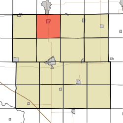
Hazleton Township, Buchanan County, Iowa
Hazleton Township, Buchanan County | |
|---|---|
 | |
| Coordinates: 42°35′57″N 091°54′16″W / 42.59917°N 91.90444°W | |
| Country | |
| State | |
| County | Buchanan |
| Area | |
| • Total | 36.36 sq mi (94.16 km2) |
| • Land | 36.27 sq mi (93.95 km2) |
| • Water | 0.08 sq mi (0.21 km2) |
| Elevation | 981 ft (299 m) |
| Population (2000) | |
| • Total | 1,733 |
| • Density | 47.8/sq mi (18.4/km2) |
| FIPS code | 19-91902[2] |
| GNIS feature ID | 0468025 |
Hazleton Township is one of sixteen townships in Buchanan County, Iowa, USA. As of the 2000 census, its population was 1,733.
Geography[edit]
Hazleton Township covers an area of 36.36 square miles (94.2 km2) and contains one incorporated settlement, Hazleton. The unincorporated community of Bryantsburg is also located in the township. According to the USGS, it contains five cemeteries: Floral Hills Memorial Gardens, Fontana, Hazleton, Kint and Saint Marys.
References[edit]
- ^ "US Board on Geographic Names". United States Geological Survey. October 25, 2007. Retrieved January 31, 2008.
- ^ "U.S. Census website". United States Census Bureau. Retrieved January 31, 2008.
External links[edit]

