
Locunolé
Locunolé
Lokunole | |
|---|---|
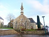
 The church of Saint-Guénolé | |
Location of Locunolé  | |
 Locunolé  Locunolé | |
| Coordinates: 47°56′13″N 3°28′38″W / 47.9369°N 3.4772°W | |
| Country | France |
| Region | Brittany |
| Department | Finistère |
| Arrondissement | Quimper |
| Canton | Quimperlé |
| Intercommunality | CA Quimperlé Communauté |
| Government | |
| • Mayor (2020–2026) | Corinne Collet[1] |
| Area 1 | 16.78 km2 (6.48 sq mi) |
| Population (2021)[2] | 1,169 |
| • Density | 70/km2 (180/sq mi) |
| Time zone | UTC+01:00 (CET) |
| • Summer (DST) | UTC+02:00 (CEST) |
| INSEE/Postal code | 29136 /29310 |
| Elevation | 12–121 m (39–397 ft) |
| 1 French Land Register data, which excludes lakes, ponds, glaciers > 1 km2 (0.386 sq mi or 247 acres) and river estuaries. | |
Locunolé (French pronunciation: [lɔkynɔle]; Breton: Lokunole) is a commune in the Finistère department of Brittany in north-western France.
Toponymy[edit]
From the Breton loc which means hermitage and 'unolé' which derive from Saint Guénolé.
Geography[edit]
The village centre is located 9 km (5.6 mi) north-east of Quimperlé. The river Ellé forms the eastern border of the commune.
Neighbouring communes[edit]
Locunolé is border by Guilligomarc'h to east, by Arzano to south, by Tréméven to west and by Querrien to north.
Places adjacent to Locunolé | ||||||||||||||||
|---|---|---|---|---|---|---|---|---|---|---|---|---|---|---|---|---|
| ||||||||||||||||
Population[edit]
Inhabitants of Locunolé are called in French Locunolois.
|
| |||||||||||||||||||||||||||||||||||||||||||||||||||||||||||||||||||||||||||||||||||||||||||||||||||||||||||||||
| ||||||||||||||||||||||||||||||||||||||||||||||||||||||||||||||||||||||||||||||||||||||||||||||||||||||||||||||||
| Source: EHESS[3] and INSEE (1968-2017)[4] | ||||||||||||||||||||||||||||||||||||||||||||||||||||||||||||||||||||||||||||||||||||||||||||||||||||||||||||||||
Map[edit]

Gallery[edit]
-
 The parish church Saint Guénolé
 -
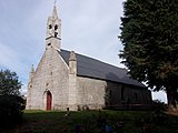
 Chapel Notre Dame de Folgoët
 -
 Chapel Sainte-Gertrude
 -
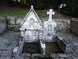 Fountains of saints
 -
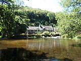 Mill Mohot


See also[edit]
- Communes of the Finistère department
- Entry on sculptor of local war memorial Jean Joncourt
References[edit]
- ^ "Répertoire national des élus: les maires". data.gouv.fr, Plateforme ouverte des données publiques françaises (in French). 9 August 2021.
- ^ "Populations légales 2021". The National Institute of Statistics and Economic Studies. 28 December 2023.
- ^ Des villages de Cassini aux communes d'aujourd'hui: Commune data sheet Locunolé, EHESS (in French).
- ^ Population en historique depuis 1968, INSEE
External links[edit]
Wikimedia Commons has media related to Locunolé.
- Mayors of Finistère Association (in French)
| Authority control databases: National |
|---|
This Finistère geographical article is a stub. You can help Wikipedia by expanding it. |