
Mellac
Mellac
Mellag | |
|---|---|
 The town hall in Mellac | |
.svg) Coat of arms | |
Location of Mellac  | |
 Mellac  Mellac | |
| Coordinates: 47°54′17″N 3°34′36″W / 47.9047°N 3.5767°W | |
| Country | France |
| Region | Brittany |
| Department | Finistère |
| Arrondissement | Quimper |
| Canton | Quimperlé |
| Intercommunality | CA Quimperlé Communauté |
| Government | |
| • Mayor (2020–2026) | Franck Chapoulie[1] |
| Area 1 | 26.38 km2 (10.19 sq mi) |
| Population (2021)[2] | 3,329 |
| • Density | 130/km2 (330/sq mi) |
| Time zone | UTC+01:00 (CET) |
| • Summer (DST) | UTC+02:00 (CEST) |
| INSEE/Postal code | 29147 /29300 |
| Elevation | 12–101 m (39–331 ft) |
| 1 French Land Register data, which excludes lakes, ponds, glaciers > 1 km2 (0.386 sq mi or 247 acres) and river estuaries. | |
Mellac (French pronunciation: [mɛlak]; Breton: Mellag) is a commune in the Finistère department of Brittany in north-western France.
Population[edit]
Inhabitants of Mellac are called in French Mellacois.
|
| ||||||||||||||||||||||||||||||||||||||||||||||||||||||||||||||||||||||||||||||||||||||||||||||||||||||||||||||||||
| |||||||||||||||||||||||||||||||||||||||||||||||||||||||||||||||||||||||||||||||||||||||||||||||||||||||||||||||||||
| Source: EHESS[3] and INSEE (1968-2020)[4] | |||||||||||||||||||||||||||||||||||||||||||||||||||||||||||||||||||||||||||||||||||||||||||||||||||||||||||||||||||
Geography[edit]
The village centre is located 4.5 km (2.8 mi) northeast of Quimperlé. Historically, Mellac belongs to Cornouaille. The river Isole forms the commune's northern and eastern borders.
Neighboring communes[edit]
Mellac is border by Saint-Thurien and Querrien to the north, by Tréméven to the east, by Quimperlé and Baye to the south and by Le Trévoux and Bannalec to the west.
Map[edit]

History[edit]
The oldest surviving parish registers date back to 1562.

Gallery[edit]
-
 Manor of Kernault
 -
 Granary of Manor of Kernault
 -
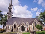 The parish church


See also[edit]
References[edit]
- ^ "Répertoire national des élus: les maires". data.gouv.fr, Plateforme ouverte des données publiques françaises (in French). 9 August 2021.
- ^ "Populations légales 2021". The National Institute of Statistics and Economic Studies. 28 December 2023.
- ^ Des villages de Cassini aux communes d'aujourd'hui: Commune data sheet Mellac, EHESS (in French).
- ^ Population en historique depuis 1968, INSEE
External links[edit]
Wikimedia Commons has media related to Mellac.
- Cultural Heritage (in French)
- Mayors of Finistère Association (in French);
| International | |
|---|---|
| National | |
This Finistère geographical article is a stub. You can help Wikipedia by expanding it. |