
Talk:Houston Heights/block book maps
Hi! Sometime I'd like to make a listing of block book maps for the Heights. WhisperToMe (talk) 12:15, 24 July 2017 (UTC)
And now I am... WhisperToMe (talk) 08:46, 7 April 2019 (UTC)
Heights proper part 1[edit]
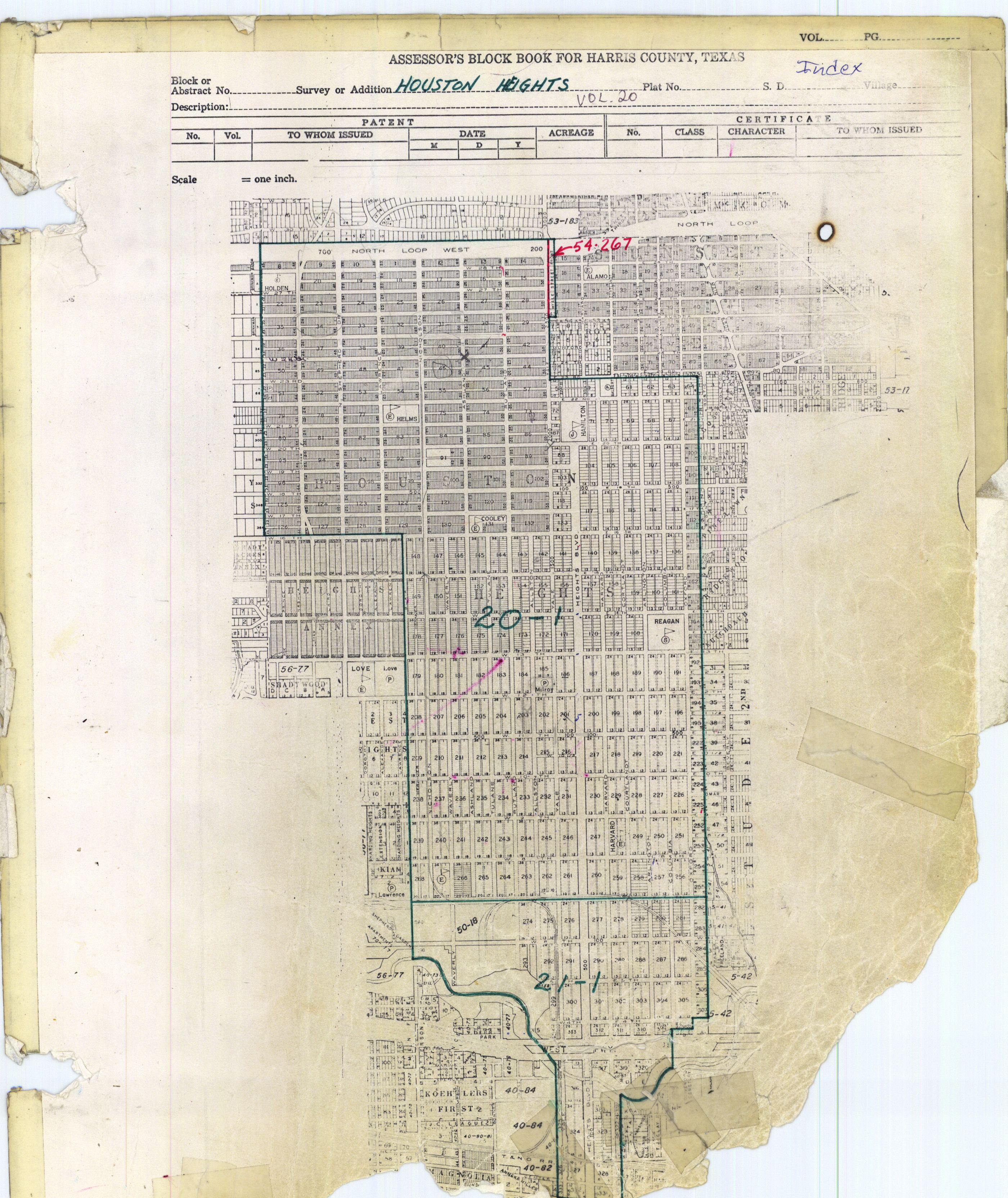
Houston Heights by block: The index map is here: http://books.tax.hctx.net/v020/AE1997_19-20_0304.jpg and http://books.tax.hctx.net/BlockBooksPDF/v020/AE1997_19-20_0304.PDF -- Holden Elementary (later Energy Institute High School and now Arabic Immersion Elementary School) is Block 21, Hamilton Middle is Block 71, Helms Elementary is block 76, Cooley Elementary is block 131, Reagan (now Heights) High occupies blocks 166 and 167 (since then I think it acquired more territory), Harvard ES is 248, and 8th Avenue Elementary (SW corner of 8th and Waverly) is 267 - Alamo ES, Field ES, Love ES, and Hogg MS are not in the Heights proper!) - also note Milroy Park (the site of the original Heights High) is block 185 (and Love Park is not within the Heights, but next to it, and Lawrence Park is not in the Heights)
- 1-3: http://books.tax.hctx.net/v020/AE1997_19-20_0306.jpg and http://books.tax.hctx.net/BlockBooksPDF/v020/AE1997_19-20_0306.PDF - Note: blocks 2-3 resubmitted for 1940 Volume 16 page 17 - Blocks 2-3 now North Loop
- ?? http://books.tax.hctx.net/v020/AE1997_19-20_0307.jpg and http://books.tax.hctx.net/BlockBooksPDF/v020/AE1997_19-20_0307.PDF
- 7: http://books.tax.hctx.net/v020/AE1997_19-20_0308.jpg and http://books.tax.hctx.net/BlockBooksPDF/v020/AE1997_19-20_0308.PDF - Resubmitted for 1940 Volume 16 Page 17
- 8: http://books.tax.hctx.net/v020/AE1997_19-20_0309.jpg and http://books.tax.hctx.net/BlockBooksPDF/v020/AE1997_19-20_0309.PDF - Indicates property to state
- 9: http://books.tax.hctx.net/v020/AE1997_19-20_0310.jpg and http://books.tax.hctx.net/BlockBooksPDF/v020/AE1997_19-20_0310.PDF - to state
- 10: http://books.tax.hctx.net/v020/AE1997_19-20_0311.jpg and http://books.tax.hctx.net/BlockBooksPDF/v020/AE1997_19-20_0311.PDF - to state
- 11: http://books.tax.hctx.net/v020/AE1997_19-20_0312.jpg and http://books.tax.hctx.net/BlockBooksPDF/v020/AE1997_19-20_0312.PDF - to state
- 12: http://books.tax.hctx.net/v020/AE1997_19-20_0313.jpg and http://books.tax.hctx.net/BlockBooksPDF/v020/AE1997_19-20_0313.PDF - to state
- 13: http://books.tax.hctx.net/v020/AE1997_19-20_0314.jpg and http://books.tax.hctx.net/BlockBooksPDF/v020/AE1997_19-20_0314.PDF - to state
- 14: http://books.tax.hctx.net/v020/AE1997_19-20_0315.jpg and http://books.tax.hctx.net/BlockBooksPDF/v020/AE1997_19-20_0315.PDF - to state
- 15: http://books.tax.hctx.net/v020/AE1997_19-20_0316.jpg and http://books.tax.hctx.net/BlockBooksPDF/v020/AE1997_19-20_0316.PDF
- 16: http://books.tax.hctx.net/v020/AE1997_19-20_0317.jpg and http://books.tax.hctx.net/BlockBooksPDF/v020/AE1997_19-20_0317.PDF
- 17: http://books.tax.hctx.net/v020/AE1997_19-20_0318.jpg and http://books.tax.hctx.net/BlockBooksPDF/v020/AE1997_19-20_0318.PDF
- 18: http://books.tax.hctx.net/v020/AE1997_19-20_0319.jpg and http://books.tax.hctx.net/BlockBooksPDF/v020/AE1997_19-20_0319.PDF
- 19: http://books.tax.hctx.net/v020/AE1997_19-20_0320.jpg and http://books.tax.hctx.net/BlockBooksPDF/v020/AE1997_19-20_0320.PDF
- 20: http://books.tax.hctx.net/v020/AE1997_19-20_0321.jpg and http://books.tax.hctx.net/BlockBooksPDF/v020/AE1997_19-20_0321.PDF
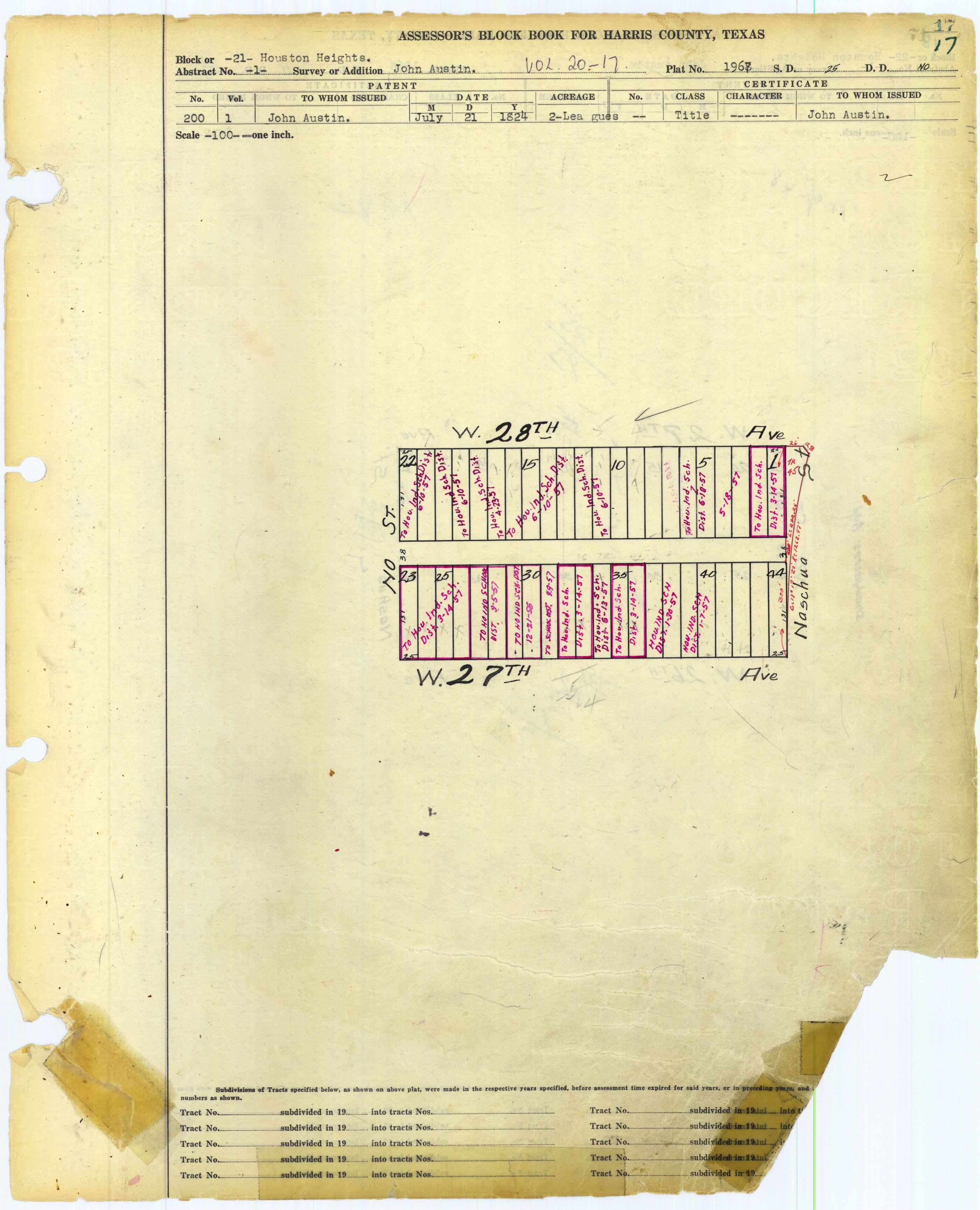
- 21: http://books.tax.hctx.net/v020/AE1997_19-20_0322.jpg and http://books.tax.hctx.net/BlockBooksPDF/v020/AE1997_19-20_0322.PDF - Marked as HISD - This would be Holden Elementary/Arabic Immersion School!
- 22: http://books.tax.hctx.net/v020/AE1997_19-20_0323.jpg and http://books.tax.hctx.net/BlockBooksPDF/v020/AE1997_19-20_0323.PDF
- 23: http://books.tax.hctx.net/v020/AE1997_19-20_0324.jpg and http://books.tax.hctx.net/BlockBooksPDF/v020/AE1997_19-20_0324.PDF
- 24: http://books.tax.hctx.net/v020/AE1997_19-20_0325.jpg and http://books.tax.hctx.net/BlockBooksPDF/v020/AE1997_19-20_0325.PDF
- 25: http://books.tax.hctx.net/v020/AE1997_19-20_0326.jpg and http://books.tax.hctx.net/BlockBooksPDF/v020/AE1997_19-20_0326.PDF
- 26: http://books.tax.hctx.net/v020/AE1997_19-20_0327.jpg and http://books.tax.hctx.net/BlockBooksPDF/v020/AE1997_19-20_0327.PDF
- 27: http://books.tax.hctx.net/v020/AE1997_19-20_0328.jpg and http://books.tax.hctx.net/BlockBooksPDF/v020/AE1997_19-20_0328.PDF
- 28: http://books.tax.hctx.net/v020/AE1997_19-20_0329.jpg and http://books.tax.hctx.net/BlockBooksPDF/v020/AE1997_19-20_0329.PDF
- 29: http://books.tax.hctx.net/v020/AE1997_19-20_0330.jpg and http://books.tax.hctx.net/BlockBooksPDF/v020/AE1997_19-20_0330.PDF
- 30: http://books.tax.hctx.net/v020/AE1997_19-20_0331.jpg and http://books.tax.hctx.net/BlockBooksPDF/v020/AE1997_19-20_0331.PDF
- 31: http://books.tax.hctx.net/v020/AE1997_19-20_0332.jpg and http://books.tax.hctx.net/BlockBooksPDF/v020/AE1997_19-20_0332.PDF
- 32: http://books.tax.hctx.net/v020/AE1997_19-20_0333.jpg and http://books.tax.hctx.net/BlockBooksPDF/v020/AE1997_19-20_0333.PDF
- 33: http://books.tax.hctx.net/v020/AE1997_19-20_0334.jpg and http://books.tax.hctx.net/BlockBooksPDF/v020/AE1997_19-20_0334.PDF
- 34: http://books.tax.hctx.net/v020/AE1997_19-20_0335.jpg and http://books.tax.hctx.net/BlockBooksPDF/v020/AE1997_19-20_0335.PDF
- 35: http://books.tax.hctx.net/v020/AE1997_19-20_0336.jpg and http://books.tax.hctx.net/BlockBooksPDF/v020/AE1997_19-20_0336.PDF
- 36: http://books.tax.hctx.net/v020/AE1997_19-20_0337.jpg and http://books.tax.hctx.net/BlockBooksPDF/v020/AE1997_19-20_0337.PDF
- 37: http://books.tax.hctx.net/v020/AE1997_19-20_0338.jpg and http://books.tax.hctx.net/BlockBooksPDF/v020/AE1997_19-20_0338.PDF
- 38: http://books.tax.hctx.net/v020/AE1997_19-20_0339.jpg and http://books.tax.hctx.net/BlockBooksPDF/v020/AE1997_19-20_0339.PDF
- 39: http://books.tax.hctx.net/v020/AE1997_19-20_0340.jpg and http://books.tax.hctx.net/BlockBooksPDF/v020/AE1997_19-20_0340.PDF
- 40: http://books.tax.hctx.net/v020/AE1997_19-20_0341.jpg and http://books.tax.hctx.net/BlockBooksPDF/v020/AE1997_19-20_0341.PDF
- 41: http://books.tax.hctx.net/v020/AE1997_19-20_0342.jpg and http://books.tax.hctx.net/BlockBooksPDF/v020/AE1997_19-20_0342.PDF - to city st Volume 279 page 426
- 42: http://books.tax.hctx.net/v020/AE1997_19-20_0343.jpg and http://books.tax.hctx.net/BlockBooksPDF/v020/AE1997_19-20_0343.PDF
- 43: http://books.tax.hctx.net/v020/AE1997_19-20_0344.jpg and http://books.tax.hctx.net/BlockBooksPDF/v020/AE1997_19-20_0344.PDF - Yale Street Front Addition, Volume 54 Page 267
- Yale Street Front Addition by block:
- 1: http://books.tax.hctx.net/BlockBooksPDF/v054/AE1997_54_0250.pdf and http://books.tax.hctx.net/v054/AE1997_54_0250.jpg - Marked Block No. 1 Sunset Heights
- 2-3: http://books.tax.hctx.net/BlockBooksPDF/v054/AE1997_54_0251.pdf and http://books.tax.hctx.net/v054/AE1997_54_0251.jpg - Parts to state
- 4-5: http://books.tax.hctx.net/BlockBooksPDF/v054/AE1997_54_0252.pdf and http://books.tax.hctx.net/v054/AE1997_54_0252.jpg - Part marked as Block 16 Sunset Heights
- 6-7: http://books.tax.hctx.net/BlockBooksPDF/v054/AE1997_54_0252.pdf and http://books.tax.hctx.net/v054/AE1997_54_0252.jpg - Part marked as Block 34 Sunset Heights
- 8: http://books.tax.hctx.net/BlockBooksPDF/v054/AE1997_54_0252.pdf and http://books.tax.hctx.net/v054/AE1997_54_0252.jpg - Part marked as Block 35 Sunset Heights
- Yale Street Front Addition by block:
- 44: http://books.tax.hctx.net/v020/AE1997_19-20_0345.jpg and http://books.tax.hctx.net/BlockBooksPDF/v020/AE1997_19-20_0345.PDF
- 45: http://books.tax.hctx.net/v020/AE1997_19-20_0346.jpg and http://books.tax.hctx.net/BlockBooksPDF/v020/AE1997_19-20_0346.PDF
- 46: http://books.tax.hctx.net/v020/AE1997_19-20_0347.jpg and http://books.tax.hctx.net/BlockBooksPDF/v020/AE1997_19-20_0347.PDF
- 47: http://books.tax.hctx.net/v020/AE1997_19-20_0348.jpg and http://books.tax.hctx.net/BlockBooksPDF/v020/AE1997_19-20_0348.PDF
- 48: http://books.tax.hctx.net/v020/AE1997_19-20_0349.jpg and http://books.tax.hctx.net/BlockBooksPDF/v020/AE1997_19-20_0349.PDF
- 49: http://books.tax.hctx.net/v020/AE1997_19-20_0350.jpg and http://books.tax.hctx.net/BlockBooksPDF/v020/AE1997_19-20_0350.PDF
- 50: http://books.tax.hctx.net/v020/AE1997_19-20_0351.jpg and http://books.tax.hctx.net/BlockBooksPDF/v020/AE1997_19-20_0351.PDF
- 51: http://books.tax.hctx.net/v020/AE1997_19-20_0352.jpg and http://books.tax.hctx.net/BlockBooksPDF/v020/AE1997_19-20_0352.PDF
- 52: http://books.tax.hctx.net/v020/AE1997_19-20_0353.jpg and http://books.tax.hctx.net/BlockBooksPDF/v020/AE1997_19-20_0353.PDF
- 53: http://books.tax.hctx.net/v020/AE1997_19-20_0354.jpg and http://books.tax.hctx.net/BlockBooksPDF/v020/AE1997_19-20_0354.PDF
- 54: http://books.tax.hctx.net/v020/AE1997_19-20_0355.jpg and http://books.tax.hctx.net/BlockBooksPDF/v020/AE1997_19-20_0355.PDF
- 55: http://books.tax.hctx.net/v020/AE1997_19-20_0356.jpg and http://books.tax.hctx.net/BlockBooksPDF/v020/AE1997_19-20_0356.PDF
- 56: http://books.tax.hctx.net/v020/AE1997_19-20_0357.jpg and http://books.tax.hctx.net/BlockBooksPDF/v020/AE1997_19-20_0357.PDF
- 57: http://books.tax.hctx.net/v020/AE1997_19-20_0358.jpg and http://books.tax.hctx.net/BlockBooksPDF/v020/AE1997_19-20_0358.PDF - Victorian Heights Section One, Volume 118, Page 602
- Victorian Heights Section One: http://books.tax.hctx.net/BlockBooksPDF/v118/AE1997_118-4_0155.pdf and http://books.tax.hctx.net/v118/AE1997_118-4_0155.jpg
- 58: http://books.tax.hctx.net/v020/AE1997_19-20_0359.jpg and http://books.tax.hctx.net/BlockBooksPDF/v020/AE1997_19-20_0359.PDF
- 59: http://books.tax.hctx.net/v020/AE1997_19-20_0360.jpg and http://books.tax.hctx.net/BlockBooksPDF/v020/AE1997_19-20_0360.PDF - Revised for 1925, see p. 54
- 60: http://books.tax.hctx.net/v020/AE1997_19-20_0361.jpg and http://books.tax.hctx.net/BlockBooksPDF/v020/AE1997_19-20_0361.PDF
- 61: http://books.tax.hctx.net/v020/AE1997_19-20_0362.jpg and http://books.tax.hctx.net/BlockBooksPDF/v020/AE1997_19-20_0362.PDF
- 62: http://books.tax.hctx.net/v020/AE1997_19-20_0363.jpg and http://books.tax.hctx.net/BlockBooksPDF/v020/AE1997_19-20_0363.PDF
- 63: http://books.tax.hctx.net/v020/AE1997_19-20_0364.jpg and http://books.tax.hctx.net/BlockBooksPDF/v020/AE1997_19-20_0364.PDF
- 64: http://books.tax.hctx.net/v020/AE1997_19-20_0365.jpg and http://books.tax.hctx.net/BlockBooksPDF/v020/AE1997_19-20_0365.PDF
- 65: http://books.tax.hctx.net/v020/AE1997_19-20_0366.jpg and http://books.tax.hctx.net/BlockBooksPDF/v020/AE1997_19-20_0366.PDF
- 66: http://books.tax.hctx.net/v020/AE1997_19-20_0367.jpg and http://books.tax.hctx.net/BlockBooksPDF/v020/AE1997_19-20_0367.PDF
- 67: http://books.tax.hctx.net/v020/AE1997_19-20_0368.jpg and http://books.tax.hctx.net/BlockBooksPDF/v020/AE1997_19-20_0368.PDF
- 68: http://books.tax.hctx.net/v020/AE1997_19-20_0369.jpg and http://books.tax.hctx.net/BlockBooksPDF/v020/AE1997_19-20_0369.PDF
- 69: http://books.tax.hctx.net/v020/AE1997_19-20_0370.jpg and http://books.tax.hctx.net/BlockBooksPDF/v020/AE1997_19-20_0370.PDF
- 70: http://books.tax.hctx.net/v020/AE1997_19-20_0371.jpg and http://books.tax.hctx.net/BlockBooksPDF/v020/AE1997_19-20_0371.PDF
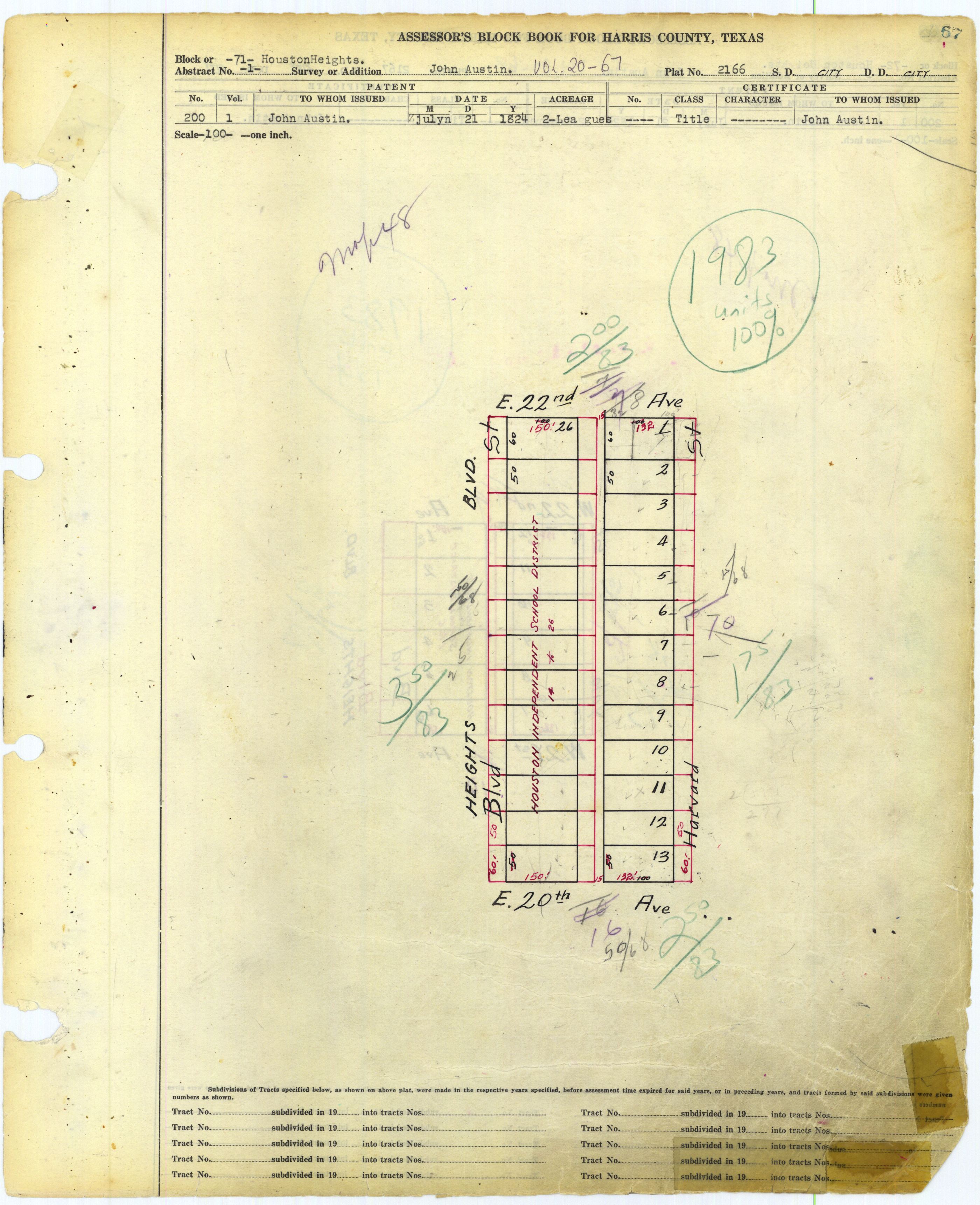
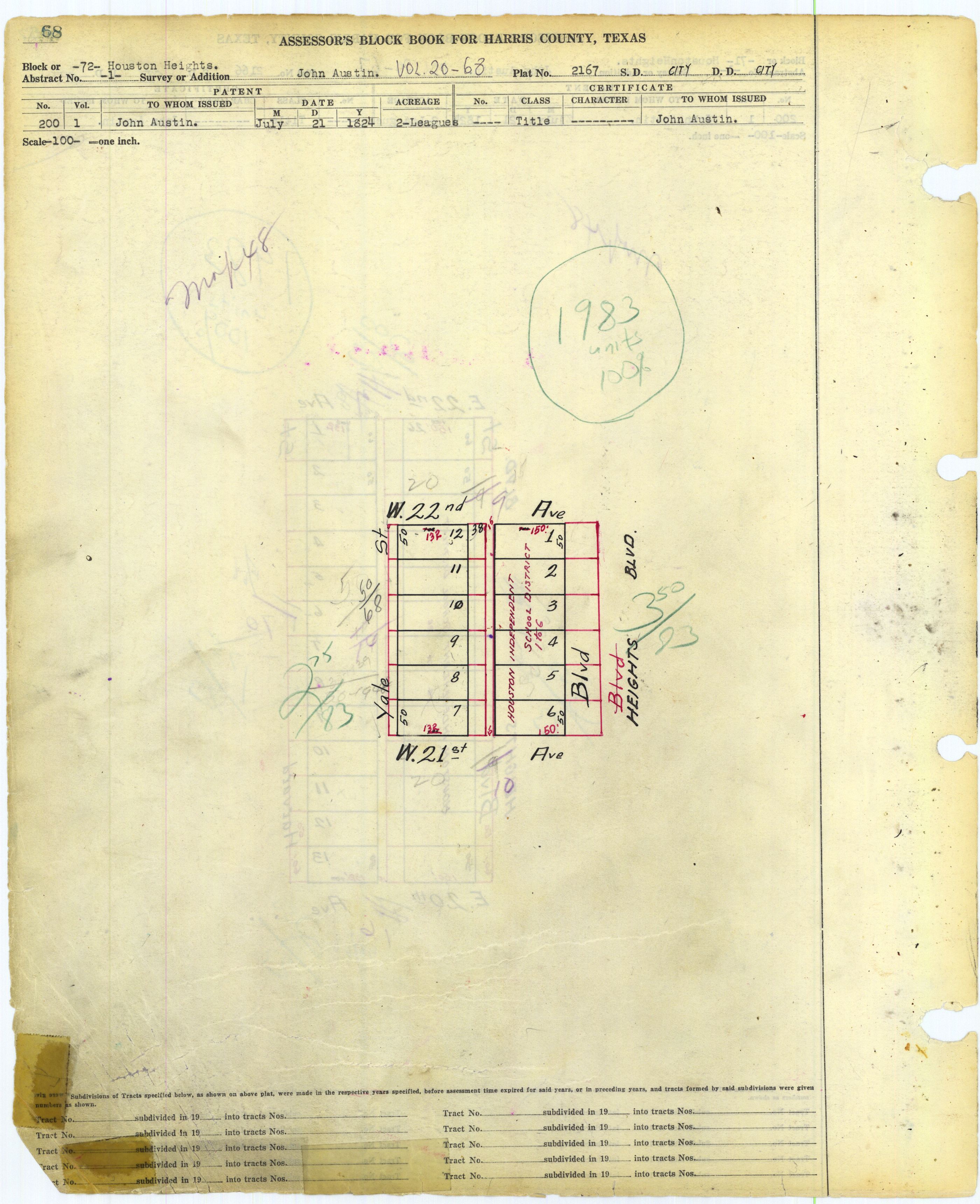
- 71: http://books.tax.hctx.net/v020/AE1997_19-20_0372.jpg and http://books.tax.hctx.net/BlockBooksPDF/v020/AE1997_19-20_0372.PDF - HISD indicated, and this would be Hamilton Middle School
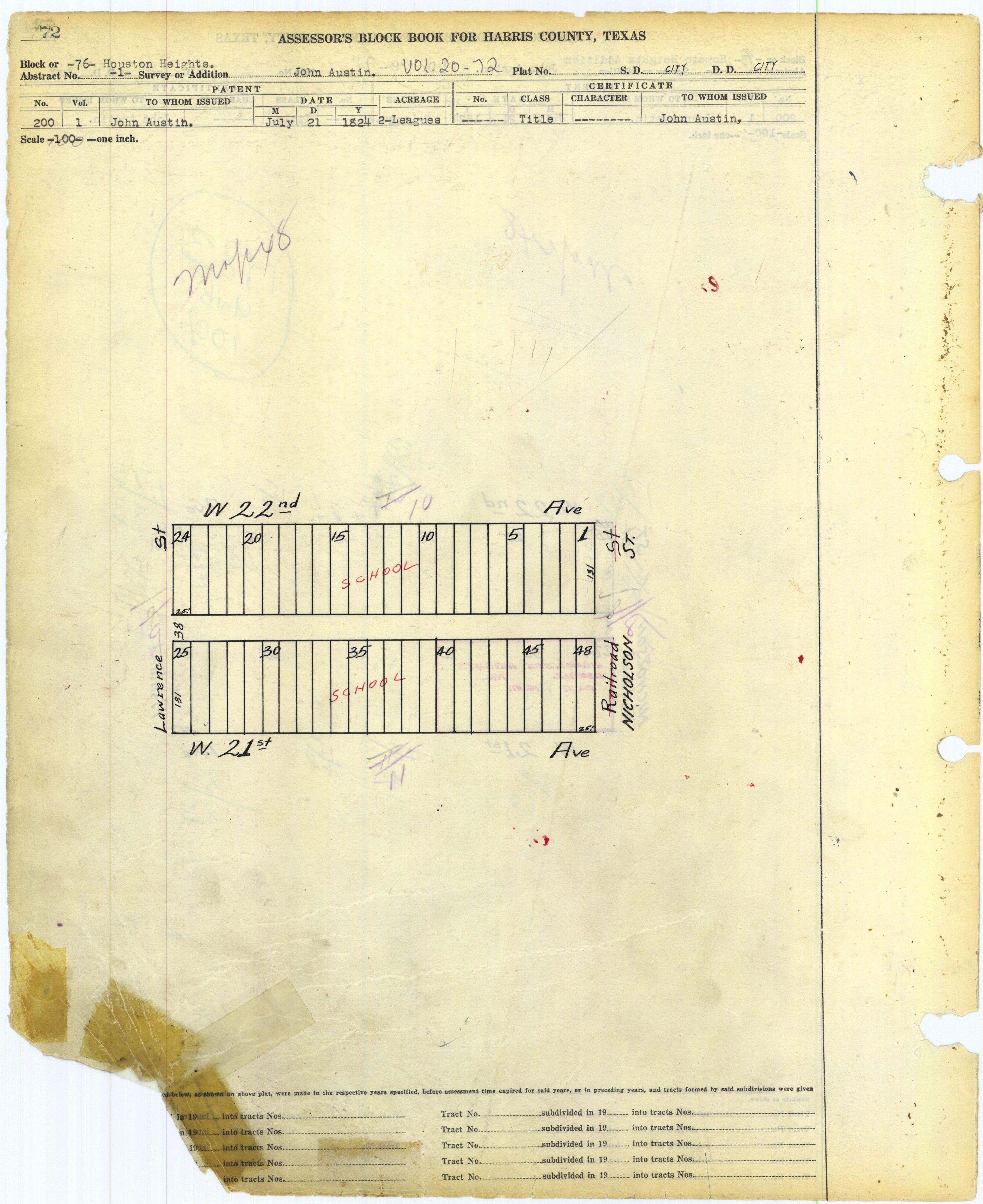
- 72: http://books.tax.hctx.net/v020/AE1997_19-20_0373.jpg and http://books.tax.hctx.net/BlockBooksPDF/v020/AE1997_19-20_0373.PDF - Indicates HISD, so part of Hamilton occupies this block
- 73: http://books.tax.hctx.net/v020/AE1997_19-20_0374.jpg and http://books.tax.hctx.net/BlockBooksPDF/v020/AE1997_19-20_0374.PDF
- 74: http://books.tax.hctx.net/v020/AE1997_19-20_0375.jpg and http://books.tax.hctx.net/BlockBooksPDF/v020/AE1997_19-20_0375.PDF
- 75: http://books.tax.hctx.net/v020/AE1997_19-20_0376.jpg and http://books.tax.hctx.net/BlockBooksPDF/v020/AE1997_19-20_0376.PDF - Nicholson Heights, Volume 117, Page 471
- Nicholson Heights: Block 1: http://books.tax.hctx.net/BlockBooksPDF/v117/AE1997_117-2_0078.pdf and http://books.tax.hctx.net/v117/AE1997_117-2_0078.jpg
- 76: http://books.tax.hctx.net/v020/AE1997_19-20_0377.jpg and http://books.tax.hctx.net/BlockBooksPDF/v020/AE1997_19-20_0377.PDF - Marked as "school", so this would be Helms Elementary
- 77: http://books.tax.hctx.net/v020/AE1997_19-20_0378.jpg and http://books.tax.hctx.net/BlockBooksPDF/v020/AE1997_19-20_0378.PDF
- 78: http://books.tax.hctx.net/v020/AE1997_19-20_0379.jpg and http://books.tax.hctx.net/BlockBooksPDF/v020/AE1997_19-20_0379.PDF
- 79: http://books.tax.hctx.net/v020/AE1997_19-20_0380.jpg and http://books.tax.hctx.net/BlockBooksPDF/v020/AE1997_19-20_0380.PDF
- 80: http://books.tax.hctx.net/v020/AE1997_19-20_0381.jpg and http://books.tax.hctx.net/BlockBooksPDF/v020/AE1997_19-20_0381.PDF
- 81: http://books.tax.hctx.net/v020/AE1997_19-20_0382.jpg and http://books.tax.hctx.net/BlockBooksPDF/v020/AE1997_19-20_0382.PDF
- 82: http://books.tax.hctx.net/v020/AE1997_19-20_0383.jpg and http://books.tax.hctx.net/BlockBooksPDF/v020/AE1997_19-20_0383.PDF
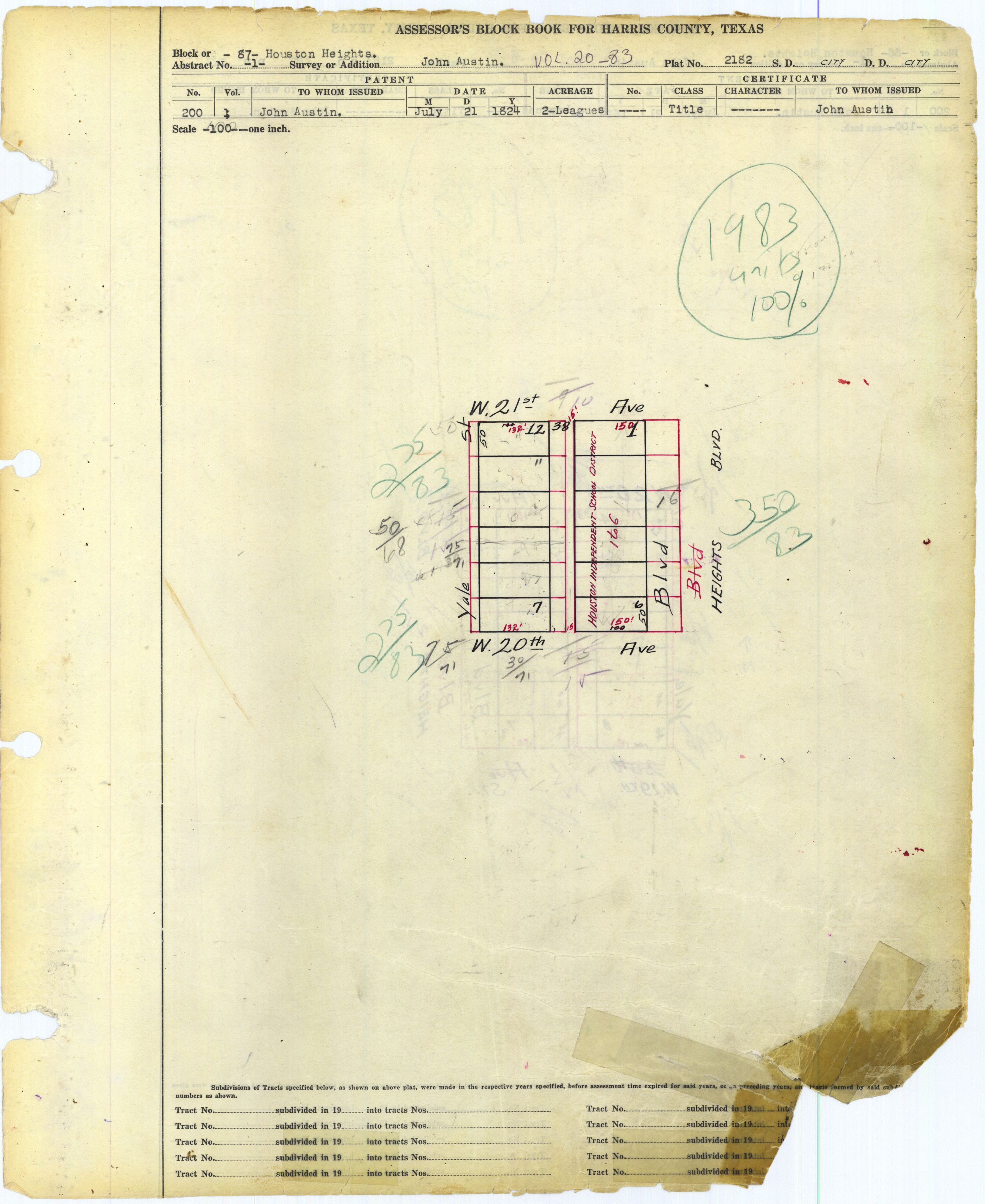
- 83: http://books.tax.hctx.net/v020/AE1997_19-20_0384.jpg and http://books.tax.hctx.net/BlockBooksPDF/v020/AE1997_19-20_0384.PDF - A part is marked "to city"
- 84: http://books.tax.hctx.net/v020/AE1997_19-20_0385.jpg and http://books.tax.hctx.net/BlockBooksPDF/v020/AE1997_19-20_0385.PDF
- 85: http://books.tax.hctx.net/v020/AE1997_19-20_0386.jpg and http://books.tax.hctx.net/BlockBooksPDF/v020/AE1997_19-20_0386.PDF
- 86: http://books.tax.hctx.net/v020/AE1997_19-20_0387.jpg and http://books.tax.hctx.net/BlockBooksPDF/v020/AE1997_19-20_0387.PDF
- 87: http://books.tax.hctx.net/v020/AE1997_19-20_0388.jpg and http://books.tax.hctx.net/BlockBooksPDF/v020/AE1997_19-20_0388.PDF - Also marked HISD, so this is Hamilton continued
- 88: http://books.tax.hctx.net/v020/AE1997_19-20_0389.jpg and http://books.tax.hctx.net/BlockBooksPDF/v020/AE1997_19-20_0389.PDF
- 89: http://books.tax.hctx.net/v020/AE1997_19-20_0390.jpg and http://books.tax.hctx.net/BlockBooksPDF/v020/AE1997_19-20_0390.PDF
- 90: http://books.tax.hctx.net/v020/AE1997_19-20_0391.jpg and http://books.tax.hctx.net/BlockBooksPDF/v020/AE1997_19-20_0391.PDF
- 91: http://books.tax.hctx.net/v020/AE1997_19-20_0392.jpg and http://books.tax.hctx.net/BlockBooksPDF/v020/AE1997_19-20_0392.PDF - Marked as a city of Houston park - now Houston Heights Waterworks Reservoir
- 92: http://books.tax.hctx.net/v020/AE1997_19-20_0393.jpg and http://books.tax.hctx.net/BlockBooksPDF/v020/AE1997_19-20_0393.PDF
- 93: http://books.tax.hctx.net/v020/AE1997_19-20_0394.jpg and http://books.tax.hctx.net/BlockBooksPDF/v020/AE1997_19-20_0394.PDF
- 94: http://books.tax.hctx.net/v020/AE1997_19-20_0395.jpg and http://books.tax.hctx.net/BlockBooksPDF/v020/AE1997_19-20_0395.PDF
- 95: http://books.tax.hctx.net/v020/AE1997_19-20_0396.jpg and http://books.tax.hctx.net/BlockBooksPDF/v020/AE1997_19-20_0396.PDF
- 96: http://books.tax.hctx.net/v020/AE1997_19-20_0397.jpg and http://books.tax.hctx.net/BlockBooksPDF/v020/AE1997_19-20_0397.PDF
- 97: http://books.tax.hctx.net/v020/AE1997_19-20_0398.jpg and http://books.tax.hctx.net/BlockBooksPDF/v020/AE1997_19-20_0398.PDF
- 98: http://books.tax.hctx.net/v020/AE1997_19-20_0399.jpg and http://books.tax.hctx.net/BlockBooksPDF/v020/AE1997_19-20_0399.PDF
- 99: http://books.tax.hctx.net/v020/AE1997_19-20_0400.jpg and http://books.tax.hctx.net/BlockBooksPDF/v020/AE1997_19-20_0400.PDF
- 100: http://books.tax.hctx.net/v020/AE1997_19-20_0401.jpg and http://books.tax.hctx.net/BlockBooksPDF/v020/AE1997_19-20_0401.PDF
- 101: http://books.tax.hctx.net/v020/AE1997_19-20_0402.jpg and http://books.tax.hctx.net/BlockBooksPDF/v020/AE1997_19-20_0402.PDF
- 102: http://books.tax.hctx.net/v020/AE1997_19-20_0403.jpg and http://books.tax.hctx.net/BlockBooksPDF/v020/AE1997_19-20_0403.PDF
- 103: http://books.tax.hctx.net/v020/AE1997_19-20_0404.jpg and http://books.tax.hctx.net/BlockBooksPDF/v020/AE1997_19-20_0404.PDF
- 104: http://books.tax.hctx.net/v020/AE1997_19-20_0405.jpg and http://books.tax.hctx.net/BlockBooksPDF/v020/AE1997_19-20_0405.PDF
- 105: http://books.tax.hctx.net/v020/AE1997_19-20_0406.jpg and http://books.tax.hctx.net/BlockBooksPDF/v020/AE1997_19-20_0406.PDF
- 106: http://books.tax.hctx.net/v020/AE1997_19-20_0407.jpg and http://books.tax.hctx.net/BlockBooksPDF/v020/AE1997_19-20_0407.PDF
- 107: http://books.tax.hctx.net/v020/AE1997_19-20_0408.jpg and http://books.tax.hctx.net/BlockBooksPDF/v020/AE1997_19-20_0408.PDF
- 108: http://books.tax.hctx.net/v020/AE1997_19-20_0409.jpg and http://books.tax.hctx.net/BlockBooksPDF/v020/AE1997_19-20_0409.PDF
- 109: http://books.tax.hctx.net/v020/AE1997_19-20_0410.jpg and http://books.tax.hctx.net/BlockBooksPDF/v020/AE1997_19-20_0410.PDF
- 110: http://books.tax.hctx.net/v020/AE1997_19-20_0411.jpg and http://books.tax.hctx.net/BlockBooksPDF/v020/AE1997_19-20_0411.PDF
- 111: http://books.tax.hctx.net/v020/AE1997_19-20_0412.jpg and http://books.tax.hctx.net/BlockBooksPDF/v020/AE1997_19-20_0412.PDF
- 112: http://books.tax.hctx.net/v020/AE1997_19-20_0413.jpg and http://books.tax.hctx.net/BlockBooksPDF/v020/AE1997_19-20_0413.PDF
- 113: http://books.tax.hctx.net/v020/AE1997_19-20_0414.jpg and http://books.tax.hctx.net/BlockBooksPDF/v020/AE1997_19-20_0414.PDF
- 114: http://books.tax.hctx.net/v020/AE1997_19-20_0415.jpg and http://books.tax.hctx.net/BlockBooksPDF/v020/AE1997_19-20_0415.PDF
- 115: http://books.tax.hctx.net/v020/AE1997_19-20_0416.jpg and http://books.tax.hctx.net/BlockBooksPDF/v020/AE1997_19-20_0416.PDF
- 116: http://books.tax.hctx.net/v020/AE1997_19-20_0417.jpg and http://books.tax.hctx.net/BlockBooksPDF/v020/AE1997_19-20_0417.PDF
- 117: http://books.tax.hctx.net/v020/AE1997_19-20_0418.jpg and http://books.tax.hctx.net/BlockBooksPDF/v020/AE1997_19-20_0418.PDF
- 118: http://books.tax.hctx.net/v020/AE1997_19-20_0419.jpg and http://books.tax.hctx.net/BlockBooksPDF/v020/AE1997_19-20_0419.PDF
- 119: http://books.tax.hctx.net/v020/AE1997_19-20_0420.jpg and http://books.tax.hctx.net/BlockBooksPDF/v020/AE1997_19-20_0420.PDF - to Heights Presbyterian Church
- 120: http://books.tax.hctx.net/v020/AE1997_19-20_0421.jpg and http://books.tax.hctx.net/BlockBooksPDF/v020/AE1997_19-20_0421.PDF
- 121: http://books.tax.hctx.net/v020/AE1997_19-20_0422.jpg and http://books.tax.hctx.net/BlockBooksPDF/v020/AE1997_19-20_0422.PDF
- 122: http://books.tax.hctx.net/v020/AE1997_19-20_0423.jpg and http://books.tax.hctx.net/BlockBooksPDF/v020/AE1997_19-20_0423.PDF - Lawrence Place, Volume 118, Page 997
- 123: http://books.tax.hctx.net/v020/AE1997_19-20_0424.jpg and http://books.tax.hctx.net/BlockBooksPDF/v020/AE1997_19-20_0424.PDF
- 124: http://books.tax.hctx.net/v020/AE1997_19-20_0425.jpg and http://books.tax.hctx.net/BlockBooksPDF/v020/AE1997_19-20_0425.PDF - a part to city
- 125: http://books.tax.hctx.net/v020/AE1997_19-20_0426.jpg and http://books.tax.hctx.net/BlockBooksPDF/v020/AE1997_19-20_0426.PDF
- 126: http://books.tax.hctx.net/v020/AE1997_19-20_0427.jpg and http://books.tax.hctx.net/BlockBooksPDF/v020/AE1997_19-20_0427.PDF
- 127: http://books.tax.hctx.net/v020/AE1997_19-20_0428.jpg and http://books.tax.hctx.net/BlockBooksPDF/v020/AE1997_19-20_0428.PDF - a part to city
- 128: http://books.tax.hctx.net/v020/AE1997_19-20_0429.jpg and http://books.tax.hctx.net/BlockBooksPDF/v020/AE1997_19-20_0429.PDF - Seventeeth Street Place - Volume 117, Page 868
- Seventeenth Street Place: http://books.tax.hctx.net/BlockBooksPDF/v117/AE1997_117-4_0039.pdf and http://books.tax.hctx.net/v117/AE1997_117-4_0039.jpg
- 129: http://books.tax.hctx.net/v020/AE1997_19-20_0430.jpg and http://books.tax.hctx.net/BlockBooksPDF/v020/AE1997_19-20_0430.PDF
- 130: http://books.tax.hctx.net/v020/AE1997_19-20_0431.jpg and http://books.tax.hctx.net/BlockBooksPDF/v020/AE1997_19-20_0431.PDF
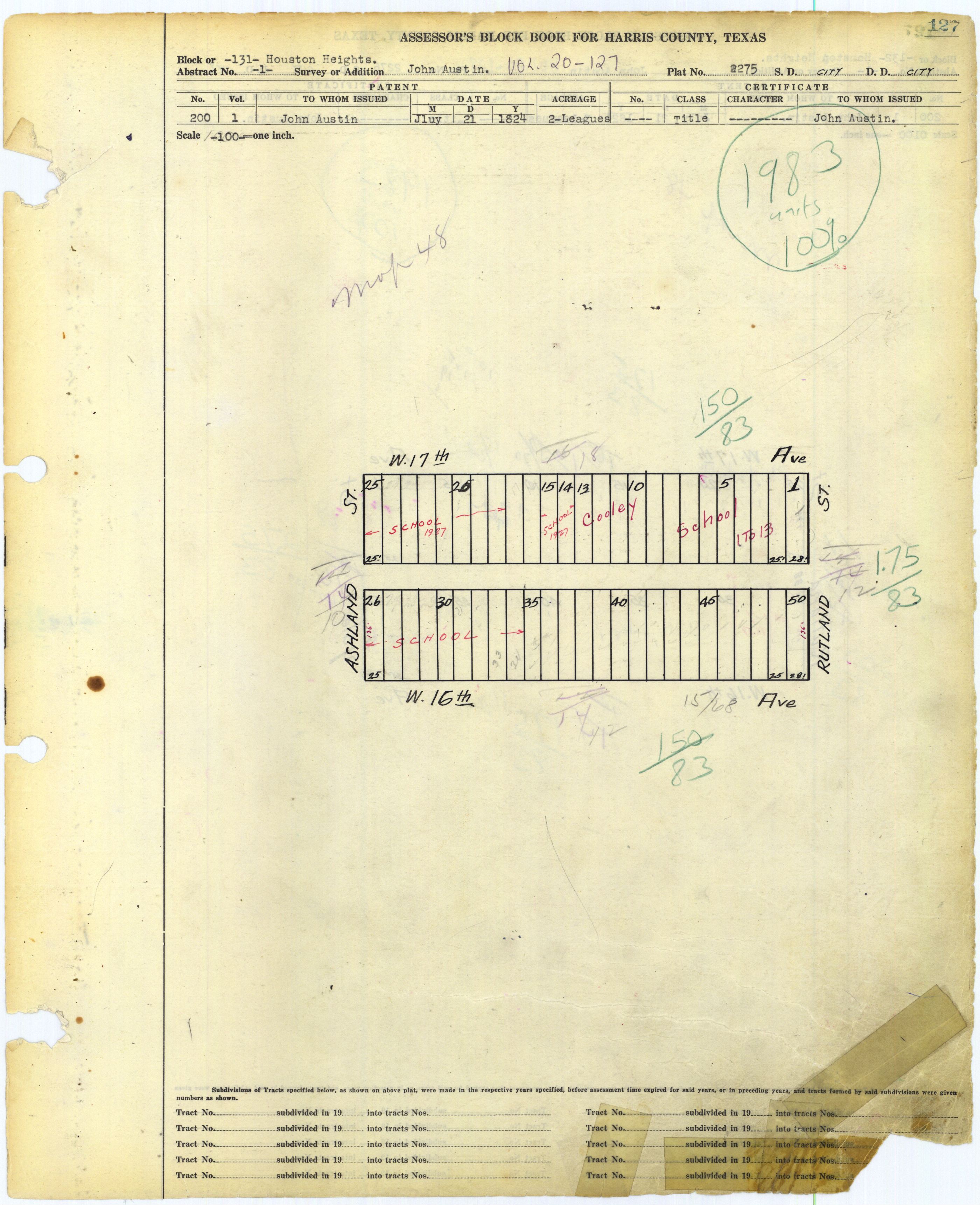
- 131: http://books.tax.hctx.net/v020/AE1997_19-20_0432.jpg and http://books.tax.hctx.net/BlockBooksPDF/v020/AE1997_19-20_0432.PDF - Marked Cooley School
- 132: http://books.tax.hctx.net/v020/AE1997_19-20_0433.jpg and http://books.tax.hctx.net/BlockBooksPDF/v020/AE1997_19-20_0433.PDF
- 133: http://books.tax.hctx.net/v020/AE1997_19-20_0434.jpg and http://books.tax.hctx.net/BlockBooksPDF/v020/AE1997_19-20_0434.PDF
- 134: http://books.tax.hctx.net/v020/AE1997_19-20_0435.jpg and http://books.tax.hctx.net/BlockBooksPDF/v020/AE1997_19-20_0435.PDF
- 135: http://books.tax.hctx.net/v020/AE1997_19-20_0436.jpg and http://books.tax.hctx.net/BlockBooksPDF/v020/AE1997_19-20_0436.PDF
- 136: http://books.tax.hctx.net/v020/AE1997_19-20_0437.jpg and http://books.tax.hctx.net/BlockBooksPDF/v020/AE1997_19-20_0437.PDF
- 137: http://books.tax.hctx.net/v020/AE1997_19-20_0438.jpg and http://books.tax.hctx.net/BlockBooksPDF/v020/AE1997_19-20_0438.PDF
- 138: http://books.tax.hctx.net/v020/AE1997_19-20_0439.jpg and http://books.tax.hctx.net/BlockBooksPDF/v020/AE1997_19-20_0439.PDF
- 139: http://books.tax.hctx.net/v020/AE1997_19-20_0440.jpg and http://books.tax.hctx.net/BlockBooksPDF/v020/AE1997_19-20_0440.PDF
- 140: http://books.tax.hctx.net/v020/AE1997_19-20_0441.jpg and http://books.tax.hctx.net/BlockBooksPDF/v020/AE1997_19-20_0441.PDF
- 140 (again): http://books.tax.hctx.net/v020/AE1997_19-20_0442.jpg and http://books.tax.hctx.net/BlockBooksPDF/v020/AE1997_19-20_0442.PDF
- 141: http://books.tax.hctx.net/v020/AE1997_19-20_0443.jpg and http://books.tax.hctx.net/BlockBooksPDF/v020/AE1997_19-20_0443.PDF
- 142: http://books.tax.hctx.net/v020/AE1997_19-20_0444.jpg and http://books.tax.hctx.net/BlockBooksPDF/v020/AE1997_19-20_0444.PDF
- 143: http://books.tax.hctx.net/v020/AE1997_19-20_0445.jpg and http://books.tax.hctx.net/BlockBooksPDF/v020/AE1997_19-20_0445.PDF
- 144: http://books.tax.hctx.net/v020/AE1997_19-20_0446.jpg and http://books.tax.hctx.net/BlockBooksPDF/v020/AE1997_19-20_0446.PDF
- 145: http://books.tax.hctx.net/v020/AE1997_19-20_0447.jpg and http://books.tax.hctx.net/BlockBooksPDF/v020/AE1997_19-20_0447.PDF
- 146: http://books.tax.hctx.net/v020/AE1997_19-20_0448.jpg and http://books.tax.hctx.net/BlockBooksPDF/v020/AE1997_19-20_0448.PDF
- 147: http://books.tax.hctx.net/v020/AE1997_19-20_0449.jpg and http://books.tax.hctx.net/BlockBooksPDF/v020/AE1997_19-20_0449.PDF
- 148: http://books.tax.hctx.net/v020/AE1997_19-20_0450.jpg and http://books.tax.hctx.net/BlockBooksPDF/v020/AE1997_19-20_0450.PDF
- 149: http://books.tax.hctx.net/v020/AE1997_19-20_0451.jpg and http://books.tax.hctx.net/BlockBooksPDF/v020/AE1997_19-20_0451.PDF
- 150: http://books.tax.hctx.net/v020/AE1997_19-20_0452.jpg and http://books.tax.hctx.net/BlockBooksPDF/v020/AE1997_19-20_0452.PDF
- 151: http://books.tax.hctx.net/v020/AE1997_19-20_0453.jpg and http://books.tax.hctx.net/BlockBooksPDF/v020/AE1997_19-20_0453.PDF
- 152: http://books.tax.hctx.net/v020/AE1997_19-20_0454.jpg and http://books.tax.hctx.net/BlockBooksPDF/v020/AE1997_19-20_0454.PDF
- Ashland Place Townhomes: http://books.tax.hctx.net/v020/AE1997_19-20_0455.jpg and http://books.tax.hctx.net/BlockBooksPDF/v020/AE1997_19-20_0455.PDF
- 153: http://books.tax.hctx.net/v020/AE1997_19-20_0456.jpg and http://books.tax.hctx.net/BlockBooksPDF/v020/AE1997_19-20_0456.PDF
- 154: http://books.tax.hctx.net/v020/AE1997_19-20_0457.jpg and http://books.tax.hctx.net/BlockBooksPDF/v020/AE1997_19-20_0457.PDF
- 155: http://books.tax.hctx.net/v020/AE1997_19-20_0455.jpg and http://books.tax.hctx.net/BlockBooksPDF/v020/AE1997_19-20_0458.PDF
- 156: http://books.tax.hctx.net/v020/AE1997_19-20_0459.jpg and http://books.tax.hctx.net/BlockBooksPDF/v020/AE1997_19-20_0459.PDF
- 157: http://books.tax.hctx.net/v020/AE1997_19-20_0460.jpg and http://books.tax.hctx.net/BlockBooksPDF/v020/AE1997_19-20_0460.PDF
- 158: http://books.tax.hctx.net/v020/AE1997_19-20_0461.jpg and http://books.tax.hctx.net/BlockBooksPDF/v020/AE1997_19-20_0461.PDF
- 159: http://books.tax.hctx.net/v020/AE1997_19-20_0462.jpg and http://books.tax.hctx.net/BlockBooksPDF/v020/AE1997_19-20_0462.PDF
- 160: http://books.tax.hctx.net/v020/AE1997_19-20_0463.jpg and http://books.tax.hctx.net/BlockBooksPDF/v020/AE1997_19-20_0463.PDF
- 161: http://books.tax.hctx.net/v020/AE1997_19-20_0464.jpg and http://books.tax.hctx.net/BlockBooksPDF/v020/AE1997_19-20_0464.PDF
- 162: http://books.tax.hctx.net/v020/AE1997_19-20_0465.jpg and http://books.tax.hctx.net/BlockBooksPDF/v020/AE1997_19-20_0465.PDF
- 163: http://books.tax.hctx.net/v020/AE1997_19-20_0466.jpg and http://books.tax.hctx.net/BlockBooksPDF/v020/AE1997_19-20_0466.PDF
- 164: http://books.tax.hctx.net/v020/AE1997_19-20_0467.jpg and http://books.tax.hctx.net/BlockBooksPDF/v020/AE1997_19-20_0467.PDF
- 165: http://books.tax.hctx.net/v020/AE1997_19-20_0468.jpg and http://books.tax.hctx.net/BlockBooksPDF/v020/AE1997_19-20_0468.PDF
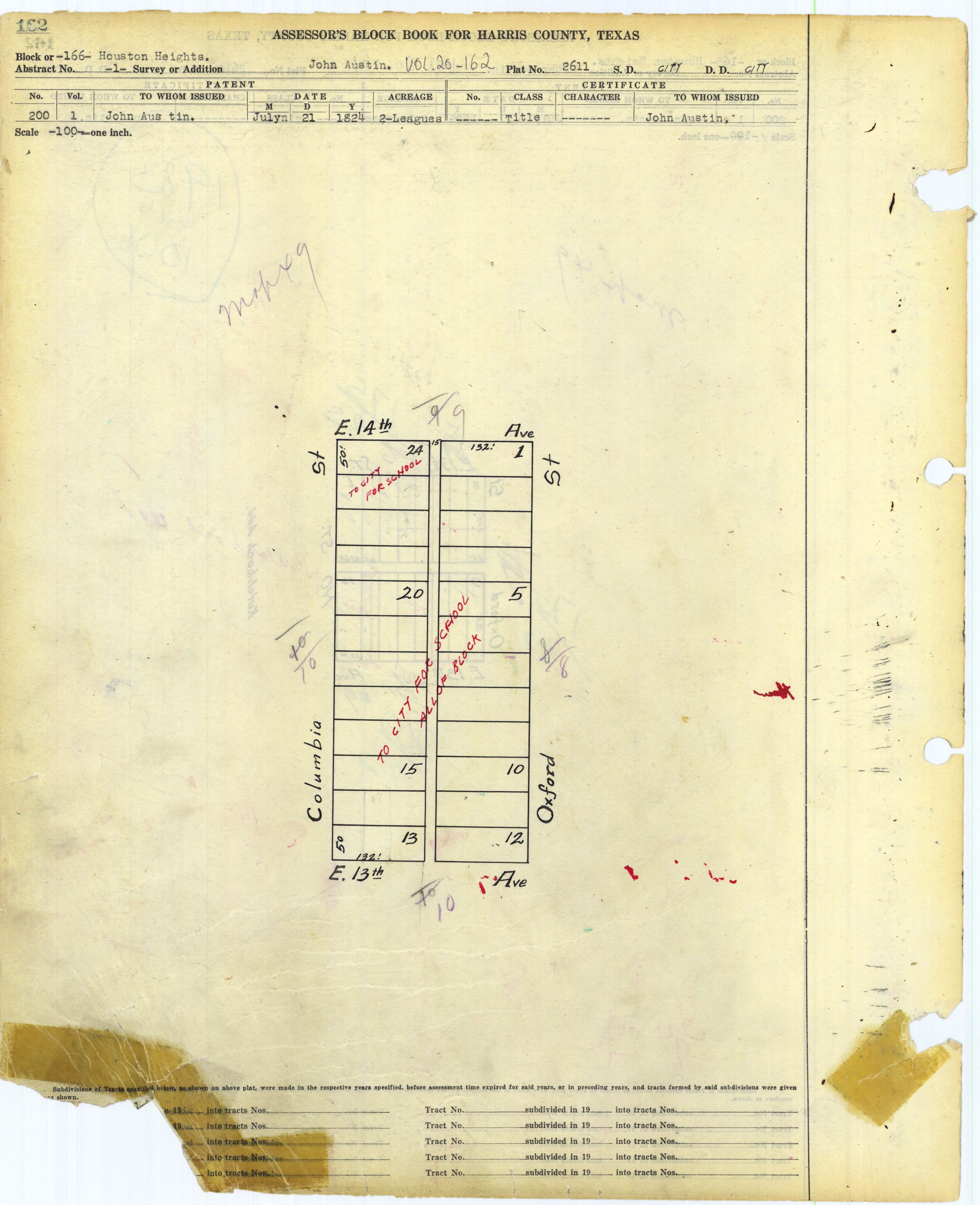
- 166: http://books.tax.hctx.net/v020/AE1997_19-20_0469.jpg and http://books.tax.hctx.net/BlockBooksPDF/v020/AE1997_19-20_0469.PDF - "to city for school" "all of block" - This would be for Reagan High, now Heights High School
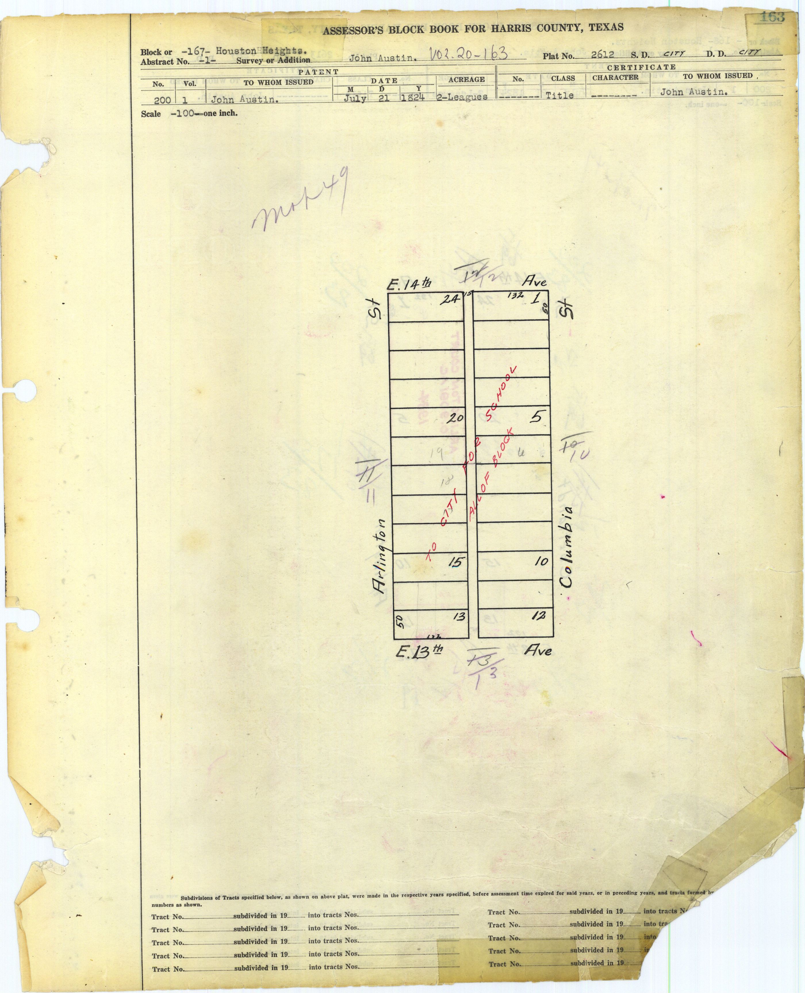
- 167: http://books.tax.hctx.net/v020/AE1997_19-20_0470.jpg and http://books.tax.hctx.net/BlockBooksPDF/v020/AE1997_19-20_0470.PDF - "to city for school" "all of block" - This would be for Reagan/Heights High
- 168: http://books.tax.hctx.net/v020/AE1997_19-20_0471.jpg and http://books.tax.hctx.net/BlockBooksPDF/v020/AE1997_19-20_0471.PDF - Arlington Court indicated
- 169: http://books.tax.hctx.net/v020/AE1997_19-20_0472.jpg and http://books.tax.hctx.net/BlockBooksPDF/v020/AE1997_19-20_0472.PDF
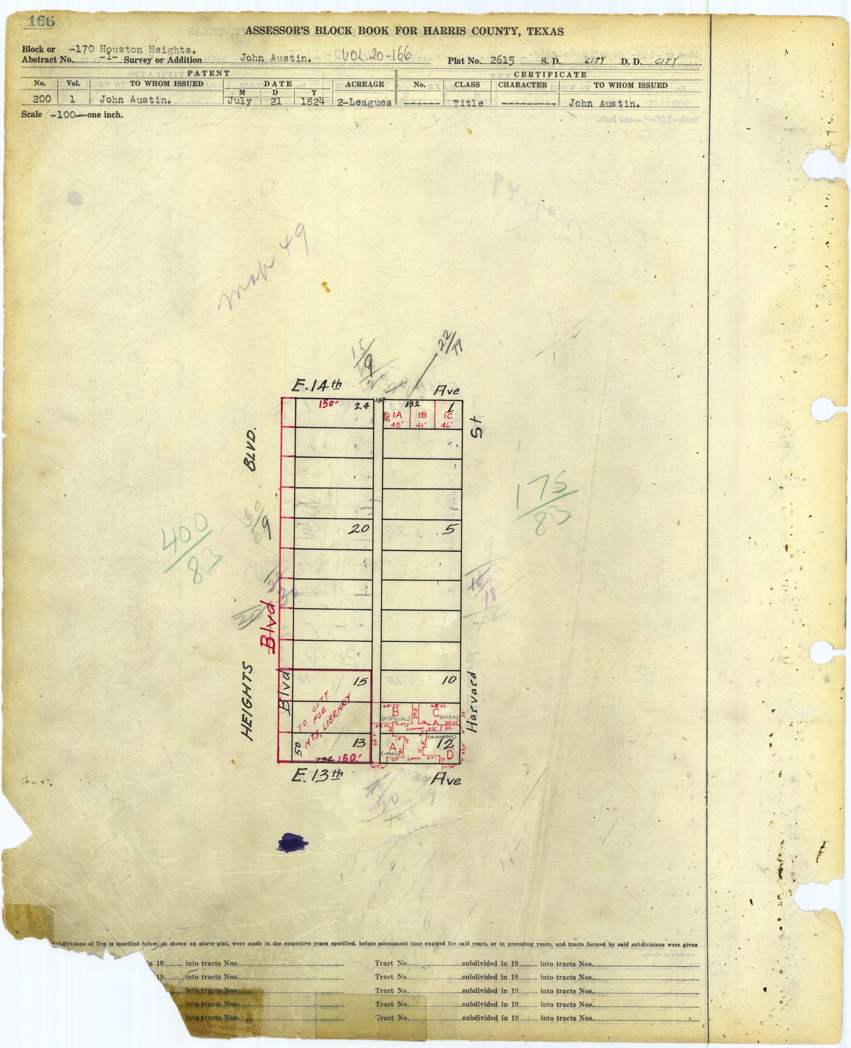
- 170: http://books.tax.hctx.net/v020/AE1997_19-20_0473.jpg and http://books.tax.hctx.net/BlockBooksPDF/v020/AE1997_19-20_0473.PDF - A part says to city for Heights Library
- 171: http://books.tax.hctx.net/v020/AE1997_19-20_0474.jpg and http://books.tax.hctx.net/BlockBooksPDF/v020/AE1997_19-20_0474.PDF
- 172: http://books.tax.hctx.net/v020/AE1997_19-20_0475.jpg and http://books.tax.hctx.net/BlockBooksPDF/v020/AE1997_19-20_0475.PDF
- 173: http://books.tax.hctx.net/v020/AE1997_19-20_0476.jpg and http://books.tax.hctx.net/BlockBooksPDF/v020/AE1997_19-20_0476.PDF
- 174: http://books.tax.hctx.net/v020/AE1997_19-20_0477.jpg and http://books.tax.hctx.net/BlockBooksPDF/v020/AE1997_19-20_0477.PDF
- 175: http://books.tax.hctx.net/v020/AE1997_19-20_0478.jpg and http://books.tax.hctx.net/BlockBooksPDF/v020/AE1997_19-20_0478.PDF
- 176: http://books.tax.hctx.net/v020/AE1997_19-20_0479.jpg and http://books.tax.hctx.net/BlockBooksPDF/v020/AE1997_19-20_0479.PDF
- 177 (abstract 1): http://books.tax.hctx.net/v020/AE1997_19-20_0480.jpg and http://books.tax.hctx.net/BlockBooksPDF/v020/AE1997_19-20_0480.PDF
- 177: http://books.tax.hctx.net/v020/AE1997_19-20_0481.jpg and http://books.tax.hctx.net/BlockBooksPDF/v020/AE1997_19-20_0481.PDF
- 178: http://books.tax.hctx.net/v020/AE1997_19-20_0482.jpg and http://books.tax.hctx.net/BlockBooksPDF/v020/AE1997_19-20_0482.PDF
- 178 (abstract 1): http://books.tax.hctx.net/v020/AE1997_19-20_0483.jpg and http://books.tax.hctx.net/BlockBooksPDF/v020/AE1997_19-20_0483.PDF
- 179: http://books.tax.hctx.net/v020/AE1997_19-20_0484.jpg and http://books.tax.hctx.net/BlockBooksPDF/v020/AE1997_19-20_0484.PDF
- 180: http://books.tax.hctx.net/v020/AE1997_19-20_0485.jpg and http://books.tax.hctx.net/BlockBooksPDF/v020/AE1997_19-20_0485.PDF
- 181: http://books.tax.hctx.net/v020/AE1997_19-20_0486.jpg and http://books.tax.hctx.net/BlockBooksPDF/v020/AE1997_19-20_0486.PDF
- 182: http://books.tax.hctx.net/v020/AE1997_19-20_0487.jpg and http://books.tax.hctx.net/BlockBooksPDF/v020/AE1997_19-20_0487.PDF
- 183: http://books.tax.hctx.net/v020/AE1997_19-20_0488.jpg and http://books.tax.hctx.net/BlockBooksPDF/v020/AE1997_19-20_0488.PDF
- 184: http://books.tax.hctx.net/v020/AE1997_19-20_0489.jpg and http://books.tax.hctx.net/BlockBooksPDF/v020/AE1997_19-20_0489.PDF
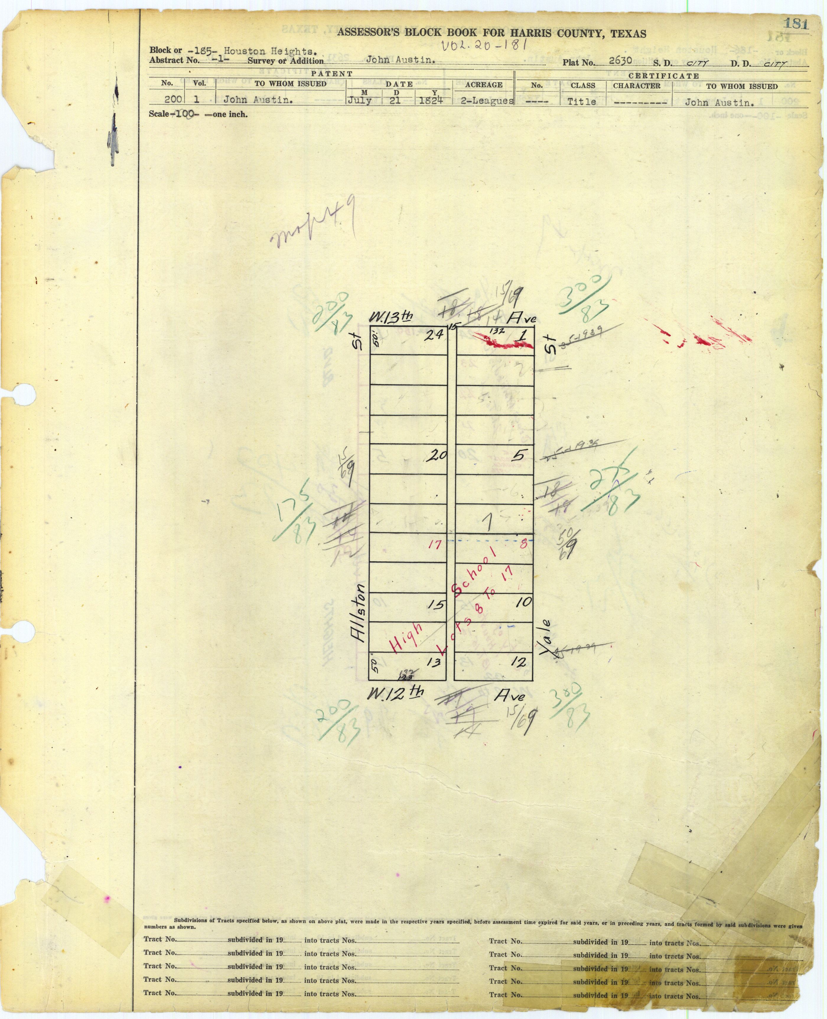
- 185: http://books.tax.hctx.net/v020/AE1997_19-20_0490.jpg and http://books.tax.hctx.net/BlockBooksPDF/v020/AE1997_19-20_0490.PDF - Marked "High School" for lots 8-17 - Now seems to be Milroy Park/Milroy Community Center
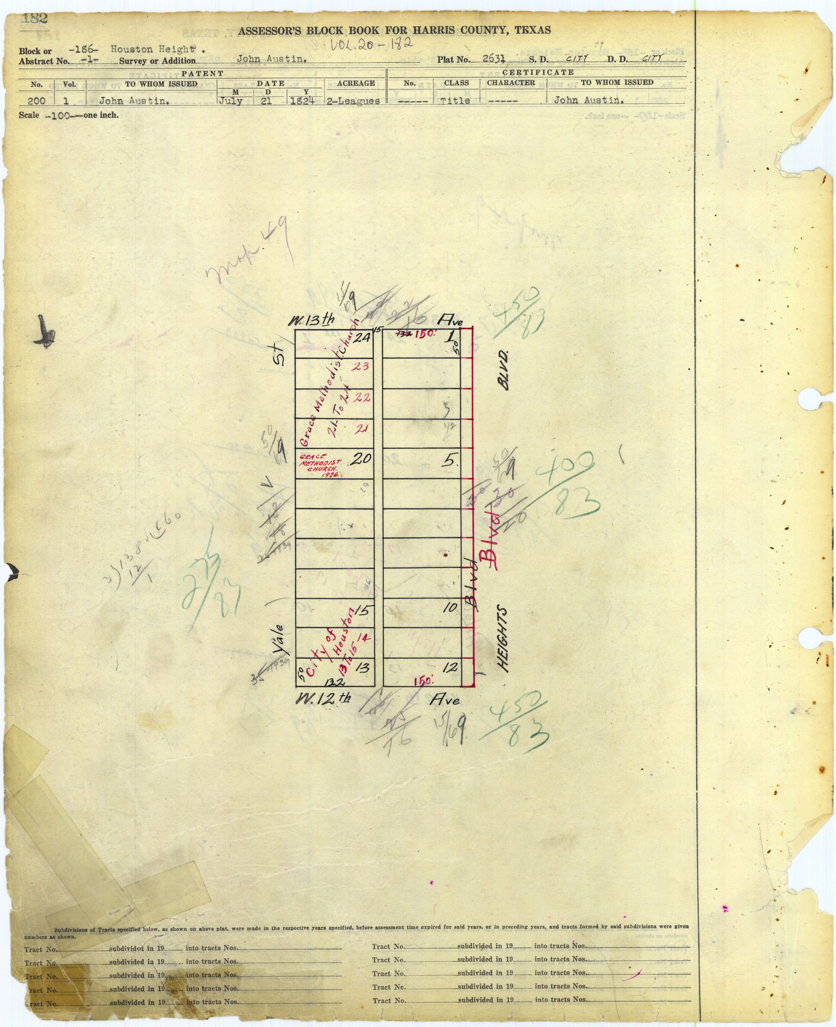
- 186: http://books.tax.hctx.net/v020/AE1997_19-20_0491.jpg and http://books.tax.hctx.net/BlockBooksPDF/v020/AE1997_19-20_0491.PDF - Grace Methodist Church and City of Houston - City property would be Houston Heights Fire Station (former) - St. Albans Catholic Church is also on this property but is not marked
- 187: http://books.tax.hctx.net/v020/AE1997_19-20_0492.jpg and http://books.tax.hctx.net/BlockBooksPDF/v020/AE1997_19-20_0492.PDF - Harvard Garden Condo
- 188: http://books.tax.hctx.net/v020/AE1997_19-20_0493.jpg and http://books.tax.hctx.net/BlockBooksPDF/v020/AE1997_19-20_0493.PDF
- 189: http://books.tax.hctx.net/v020/AE1997_19-20_0494.jpg and http://books.tax.hctx.net/BlockBooksPDF/v020/AE1997_19-20_0494.PDF
- 190: http://books.tax.hctx.net/v020/AE1997_19-20_0495.jpg and http://books.tax.hctx.net/BlockBooksPDF/v020/AE1997_19-20_0495.PDF
- 191: http://books.tax.hctx.net/v020/AE1997_19-20_0496.jpg and http://books.tax.hctx.net/BlockBooksPDF/v020/AE1997_19-20_0496.PDF
- 192: http://books.tax.hctx.net/v020/AE1997_19-20_0497.jpg and http://books.tax.hctx.net/BlockBooksPDF/v020/AE1997_19-20_0497.PDF
- 193: http://books.tax.hctx.net/v020/AE1997_19-20_0498.jpg and http://books.tax.hctx.net/BlockBooksPDF/v020/AE1997_19-20_0498.PDF
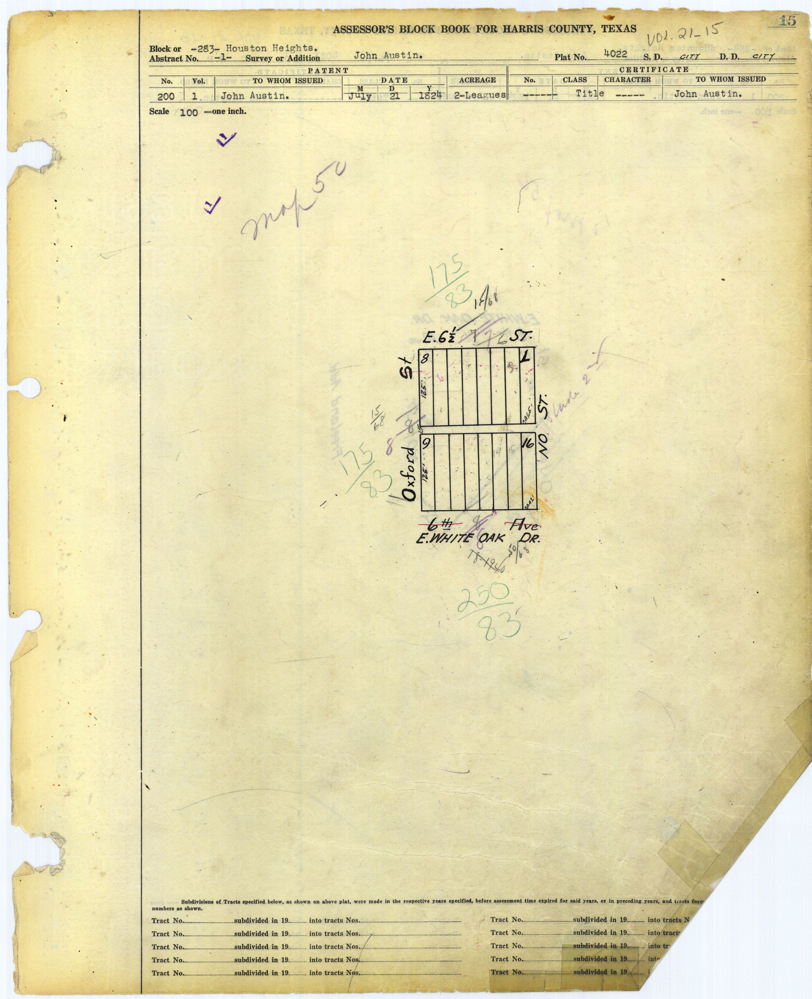
- 194: http://books.tax.hctx.net/v020/AE1997_19-20_0499.jpg and http://books.tax.hctx.net/BlockBooksPDF/v020/AE1997_19-20_0499.PDF - Oxford Place, Volume 118, Page 681
- 195: http://books.tax.hctx.net/v020/AE1997_19-20_0500.jpg and http://books.tax.hctx.net/BlockBooksPDF/v020/AE1997_19-20_0500.PDF
- 196: http://books.tax.hctx.net/v020/AE1997_19-20_0501.jpg and http://books.tax.hctx.net/BlockBooksPDF/v020/AE1997_19-20_0501.PDF
- 197: http://books.tax.hctx.net/v020/AE1997_19-20_0502.jpg and http://books.tax.hctx.net/BlockBooksPDF/v020/AE1997_19-20_0502.PDF
- 198: http://books.tax.hctx.net/v020/AE1997_19-20_0503.jpg and http://books.tax.hctx.net/BlockBooksPDF/v020/AE1997_19-20_0503.PDF
- 199: http://books.tax.hctx.net/v020/AE1997_19-20_0504.jpg and http://books.tax.hctx.net/BlockBooksPDF/v020/AE1997_19-20_0504.PDF - Harvard House Condominium
- 200: http://books.tax.hctx.net/v020/AE1997_19-20_0505.jpg and http://books.tax.hctx.net/BlockBooksPDF/v020/AE1997_19-20_0505.PDF
- 201: http://books.tax.hctx.net/v020/AE1997_19-20_0506.jpg and http://books.tax.hctx.net/BlockBooksPDF/v020/AE1997_19-20_0506.PDF
- 202: http://books.tax.hctx.net/v020/AE1997_19-20_0507.jpg and http://books.tax.hctx.net/BlockBooksPDF/v020/AE1997_19-20_0507.PDF
- 203: http://books.tax.hctx.net/v020/AE1997_19-20_0508.jpg and http://books.tax.hctx.net/BlockBooksPDF/v020/AE1997_19-20_0508.PDF
- 204: http://books.tax.hctx.net/v020/AE1997_19-20_0509.jpg and http://books.tax.hctx.net/BlockBooksPDF/v020/AE1997_19-20_0509.PDF
- 205: http://books.tax.hctx.net/v020/AE1997_19-20_0510.jpg and http://books.tax.hctx.net/BlockBooksPDF/v020/AE1997_19-20_0510.PDF
- 206: http://books.tax.hctx.net/v020/AE1997_19-20_0511.jpg and http://books.tax.hctx.net/BlockBooksPDF/v020/AE1997_19-20_0511.PDF
- 207: http://books.tax.hctx.net/v020/AE1997_19-20_0512.jpg and http://books.tax.hctx.net/BlockBooksPDF/v020/AE1997_19-20_0512.PDF
- 208: http://books.tax.hctx.net/v020/AE1997_19-20_0513.jpg and http://books.tax.hctx.net/BlockBooksPDF/v020/AE1997_19-20_0513.PDF
- 209: http://books.tax.hctx.net/v020/AE1997_19-20_0514.jpg and http://books.tax.hctx.net/BlockBooksPDF/v020/AE1997_19-20_0514.PDF
- 210: http://books.tax.hctx.net/v020/AE1997_19-20_0515.jpg and http://books.tax.hctx.net/BlockBooksPDF/v020/AE1997_19-20_0515.PDF
- 211: http://books.tax.hctx.net/v020/AE1997_19-20_0516.jpg and http://books.tax.hctx.net/BlockBooksPDF/v020/AE1997_19-20_0516.PDF
- 212: http://books.tax.hctx.net/v020/AE1997_19-20_0517.jpg and http://books.tax.hctx.net/BlockBooksPDF/v020/AE1997_19-20_0517.PDF
- 213: http://books.tax.hctx.net/v020/AE1997_19-20_0518.jpg and http://books.tax.hctx.net/BlockBooksPDF/v020/AE1997_19-20_0518.PDF
- 214: http://books.tax.hctx.net/v020/AE1997_19-20_0519.jpg and http://books.tax.hctx.net/BlockBooksPDF/v020/AE1997_19-20_0519.PDF
- 215: http://books.tax.hctx.net/v020/AE1997_19-20_0520.jpg and http://books.tax.hctx.net/BlockBooksPDF/v020/AE1997_19-20_0520.PDF
- 216: http://books.tax.hctx.net/v020/AE1997_19-20_0521.jpg and http://books.tax.hctx.net/BlockBooksPDF/v020/AE1997_19-20_0521.PDF
- Patio Homesites (Heights @ 10th): http://books.tax.hctx.net/v020/AE1997_19-20_0522.jpg and http://books.tax.hctx.net/BlockBooksPDF/v020/AE1997_19-20_0522.PDF
- 217: http://books.tax.hctx.net/v020/AE1997_19-20_0523.jpg and http://books.tax.hctx.net/BlockBooksPDF/v020/AE1997_19-20_0523.PDF - says see new map PG-213-1
- 218: http://books.tax.hctx.net/v020/AE1997_19-20_0524.jpg and http://books.tax.hctx.net/BlockBooksPDF/v020/AE1997_19-20_0524.PDF - Indicates a Catholic Church - That would be All Saints Catholic Church
- 219: http://books.tax.hctx.net/v020/AE1997_19-20_0525.jpg and http://books.tax.hctx.net/BlockBooksPDF/v020/AE1997_19-20_0525.PDF
- 220: http://books.tax.hctx.net/v020/AE1997_19-20_0526.jpg and http://books.tax.hctx.net/BlockBooksPDF/v020/AE1997_19-20_0526.PDF
- 221: http://books.tax.hctx.net/v020/AE1997_19-20_0527.jpg and http://books.tax.hctx.net/BlockBooksPDF/v020/AE1997_19-20_0527.PDF
- 222: http://books.tax.hctx.net/v020/AE1997_19-20_0528.jpg and http://books.tax.hctx.net/BlockBooksPDF/v020/AE1997_19-20_0528.PDF
- 223: http://books.tax.hctx.net/v020/AE1997_19-20_0529.jpg and http://books.tax.hctx.net/BlockBooksPDF/v020/AE1997_19-20_0529.PDF
- 224: http://books.tax.hctx.net/v020/AE1997_19-20_0530.jpg and http://books.tax.hctx.net/BlockBooksPDF/v020/AE1997_19-20_0530.PDF
- 225: http://books.tax.hctx.net/v020/AE1997_19-20_0531.jpg and http://books.tax.hctx.net/BlockBooksPDF/v020/AE1997_19-20_0531.PDF
- 226: http://books.tax.hctx.net/v020/AE1997_19-20_0532.jpg and http://books.tax.hctx.net/BlockBooksPDF/v020/AE1997_19-20_0532.PDF
- 227: http://books.tax.hctx.net/v020/AE1997_19-20_0533.jpg and http://books.tax.hctx.net/BlockBooksPDF/v020/AE1997_19-20_0533.PDF
- 228: http://books.tax.hctx.net/v020/AE1997_19-20_0534.jpg and http://books.tax.hctx.net/BlockBooksPDF/v020/AE1997_19-20_0534.PDF
- 229: http://books.tax.hctx.net/v020/AE1997_19-20_0535.jpg and http://books.tax.hctx.net/BlockBooksPDF/v020/AE1997_19-20_0535.PDF
- 230: http://books.tax.hctx.net/v020/AE1997_19-20_0536.jpg and http://books.tax.hctx.net/BlockBooksPDF/v020/AE1997_19-20_0536.PDF
- 231: http://books.tax.hctx.net/v020/AE1997_19-20_0537.jpg and http://books.tax.hctx.net/BlockBooksPDF/v020/AE1997_19-20_0537.PDF
- 232: http://books.tax.hctx.net/v020/AE1997_19-20_0538.jpg and http://books.tax.hctx.net/BlockBooksPDF/v020/AE1997_19-20_0538.PDF
- 233: http://books.tax.hctx.net/v020/AE1997_19-20_0539.jpg and http://books.tax.hctx.net/BlockBooksPDF/v020/AE1997_19-20_0539.PDF
- 234: http://books.tax.hctx.net/v020/AE1997_19-20_0540.jpg and http://books.tax.hctx.net/BlockBooksPDF/v020/AE1997_19-20_0540.PDF
- 235: http://books.tax.hctx.net/v020/AE1997_19-20_0541.jpg and http://books.tax.hctx.net/BlockBooksPDF/v020/AE1997_19-20_0541.PDF
- 236: http://books.tax.hctx.net/v020/AE1997_19-20_0542.jpg and http://books.tax.hctx.net/BlockBooksPDF/v020/AE1997_19-20_0542.PDF - says see replat next page
- Houston Heights Addition Amending Block 236 Lots 33-36: http://books.tax.hctx.net/v020/AE1997_19-20_0543.jpg and http://books.tax.hctx.net/BlockBooksPDF/v020/AE1997_19-20_0543.PDF
- 237 (presumed): http://books.tax.hctx.net/v020/AE1997_19-20_0544.jpg and http://books.tax.hctx.net/BlockBooksPDF/v020/AE1997_19-20_0544.PDF
- 238: http://books.tax.hctx.net/v020/AE1997_19-20_0545.jpg and http://books.tax.hctx.net/BlockBooksPDF/v020/AE1997_19-20_0545.PDF
- 239: http://books.tax.hctx.net/v020/AE1997_19-20_0546.jpg and http://books.tax.hctx.net/BlockBooksPDF/v020/AE1997_19-20_0546.PDF
- 240: http://books.tax.hctx.net/v020/AE1997_19-20_0547.jpg and http://books.tax.hctx.net/BlockBooksPDF/v020/AE1997_19-20_0547.PDF
- 241: http://books.tax.hctx.net/v020/AE1997_19-20_0548.jpg and http://books.tax.hctx.net/BlockBooksPDF/v020/AE1997_19-20_0548.PDF
- 242: http://books.tax.hctx.net/v020/AE1997_19-20_0549.jpg and http://books.tax.hctx.net/BlockBooksPDF/v020/AE1997_19-20_0549.PDF
- 243: http://books.tax.hctx.net/v020/AE1997_19-20_0550.jpg and http://books.tax.hctx.net/BlockBooksPDF/v020/AE1997_19-20_0550.PDF
- 244: http://books.tax.hctx.net/v020/AE1997_19-20_0551.jpg and http://books.tax.hctx.net/BlockBooksPDF/v020/AE1997_19-20_0551.PDF
- 245: http://books.tax.hctx.net/v020/AE1997_19-20_0552.jpg and http://books.tax.hctx.net/BlockBooksPDF/v020/AE1997_19-20_0552.PDF
- 246: http://books.tax.hctx.net/v020/AE1997_19-20_0553.jpg and http://books.tax.hctx.net/BlockBooksPDF/v020/AE1997_19-20_0553.PDF
- 247: http://books.tax.hctx.net/v020/AE1997_19-20_0554.jpg and http://books.tax.hctx.net/BlockBooksPDF/v020/AE1997_19-20_0554.PDF
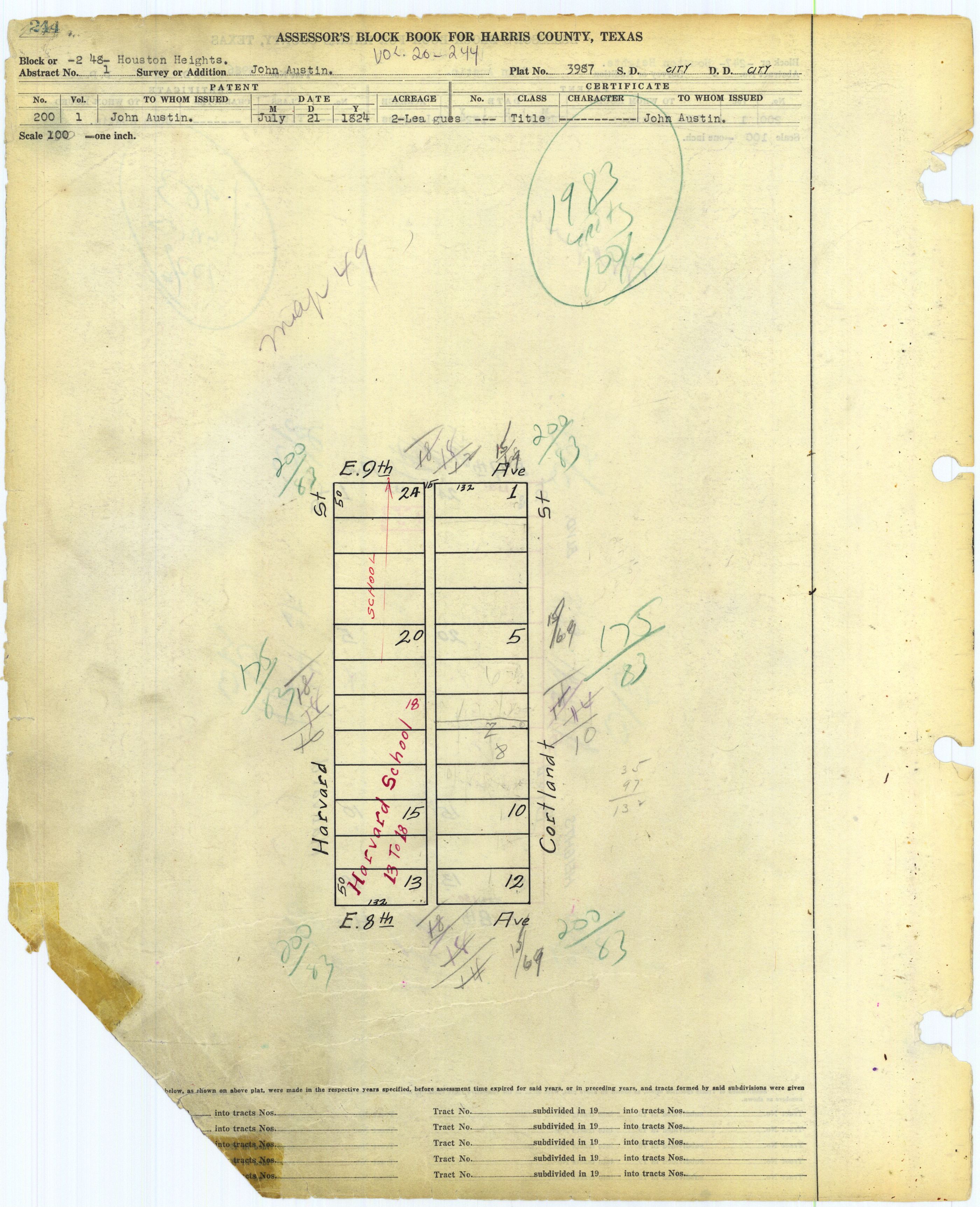
- 248: http://books.tax.hctx.net/v020/AE1997_19-20_0555.jpg and http://books.tax.hctx.net/BlockBooksPDF/v020/AE1997_19-20_0555.PDF - Indicates Harvard Elementary School (Houston)
- 249: http://books.tax.hctx.net/v020/AE1997_19-20_0556.jpg and http://books.tax.hctx.net/BlockBooksPDF/v020/AE1997_19-20_0556.PDF
- 250: http://books.tax.hctx.net/v020/AE1997_19-20_0557.jpg and http://books.tax.hctx.net/BlockBooksPDF/v020/AE1997_19-20_0557.PDF
- 251: http://books.tax.hctx.net/v020/AE1997_19-20_0558.jpg and http://books.tax.hctx.net/BlockBooksPDF/v020/AE1997_19-20_0558.PDF - Indicates Oxford Lots, Volume 118, Page 555
- 252: http://books.tax.hctx.net/v020/AE1997_19-20_0559.jpg and http://books.tax.hctx.net/BlockBooksPDF/v020/AE1997_19-20_0559.PDF
- 253: http://books.tax.hctx.net/v020/AE1997_19-20_0560.jpg and http://books.tax.hctx.net/BlockBooksPDF/v020/AE1997_19-20_0560.PDF
- 254: http://books.tax.hctx.net/v020/AE1997_19-20_0561.jpg and http://books.tax.hctx.net/BlockBooksPDF/v020/AE1997_19-20_0561.PDF - Part Sterling Heights, Volume 117, Page 581
- Sterling Heights: http://books.tax.hctx.net/BlockBooksPDF/v117/AE1997_117-2_0218.pdf and http://books.tax.hctx.net/v117/AE1997_117-2_0218.jpg - Surrounded by blocks of the Heights and Studes
- 255: http://books.tax.hctx.net/v020/AE1997_19-20_0562.jpg and http://books.tax.hctx.net/BlockBooksPDF/v020/AE1997_19-20_0562.PDF
- 256: http://books.tax.hctx.net/v020/AE1997_19-20_0563.jpg and http://books.tax.hctx.net/BlockBooksPDF/v020/AE1997_19-20_0563.PDF
- 257: http://books.tax.hctx.net/v020/AE1997_19-20_0564.jpg and http://books.tax.hctx.net/BlockBooksPDF/v020/AE1997_19-20_0564.PDF
- 258: http://books.tax.hctx.net/v020/AE1997_19-20_0565.jpg and http://books.tax.hctx.net/BlockBooksPDF/v020/AE1997_19-20_0565.PDF - Arlington Heights condo
- 259: http://books.tax.hctx.net/v020/AE1997_19-20_0566.jpg and http://books.tax.hctx.net/BlockBooksPDF/v020/AE1997_19-20_0566.PDF - M.K.&T Ry. Co.
- 260: http://books.tax.hctx.net/v020/AE1997_19-20_0567.jpg and http://books.tax.hctx.net/BlockBooksPDF/v020/AE1997_19-20_0567.PDF - Donovan Park would be here, but it is not indicated on this map
- 261: http://books.tax.hctx.net/v020/AE1997_19-20_0568.jpg and http://books.tax.hctx.net/BlockBooksPDF/v020/AE1997_19-20_0568.PDF - Hightower Estates - Volume 119, Page 881
- Hightower Estates: books.tax.hctx.net/BlockBooksPDF/v119/AE1997_119-2_0529.PDF and http://books.tax.hctx.net/v119/AE1997_119-2_0529.jpg
- 262: http://books.tax.hctx.net/v020/AE1997_19-20_0569.jpg and http://books.tax.hctx.net/BlockBooksPDF/v020/AE1997_19-20_0569.PDF
- 263: http://books.tax.hctx.net/v020/AE1997_19-20_0570.jpg and http://books.tax.hctx.net/BlockBooksPDF/v020/AE1997_19-20_0570.PDF
- 264: http://books.tax.hctx.net/v020/AE1997_19-20_0571.jpg and http://books.tax.hctx.net/BlockBooksPDF/v020/AE1997_19-20_0571.PDF
- 265: http://books.tax.hctx.net/v020/AE1997_19-20_0572.jpg and http://books.tax.hctx.net/BlockBooksPDF/v020/AE1997_19-20_0572.PDF
- 266: http://books.tax.hctx.net/v020/AE1997_19-20_0573.jpg and http://books.tax.hctx.net/BlockBooksPDF/v020/AE1997_19-20_0573.PDF
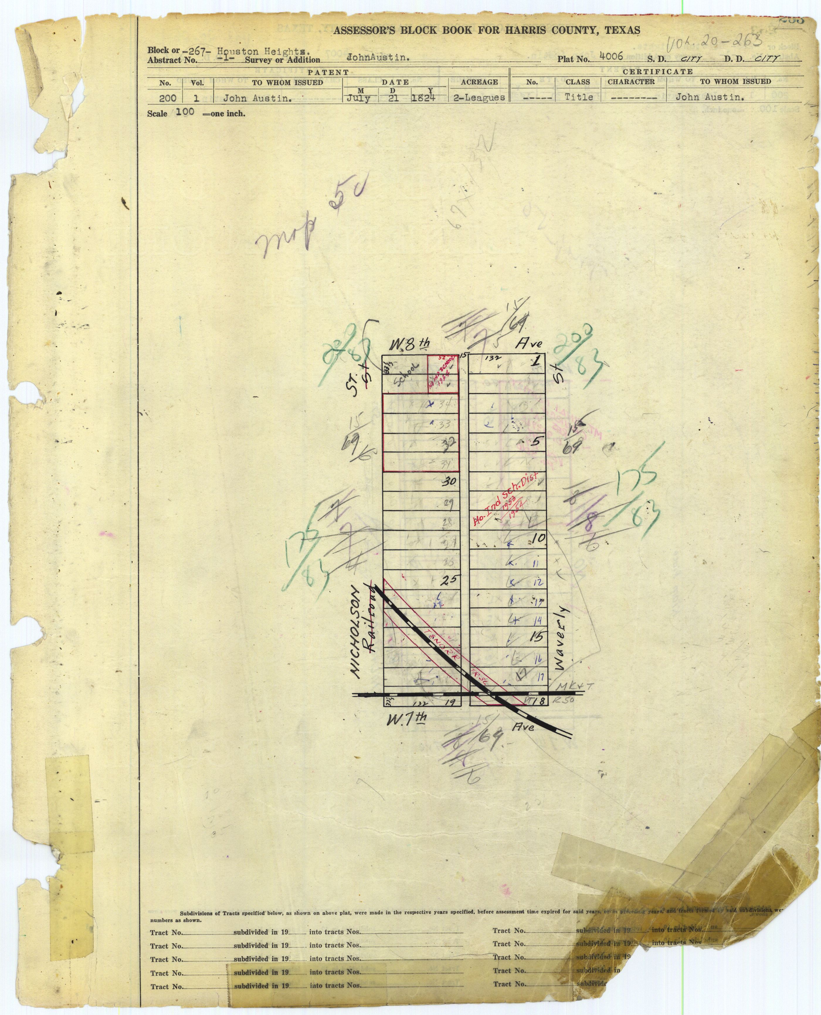
- 267: http://books.tax.hctx.net/v020/AE1997_19-20_0574.jpg and http://books.tax.hctx.net/BlockBooksPDF/v020/AE1997_19-20_0574.PDF - "Ho. Ind Sch. Dist" and "Ho Ind School" 1954 - This would be 8th Avenue Elementary School
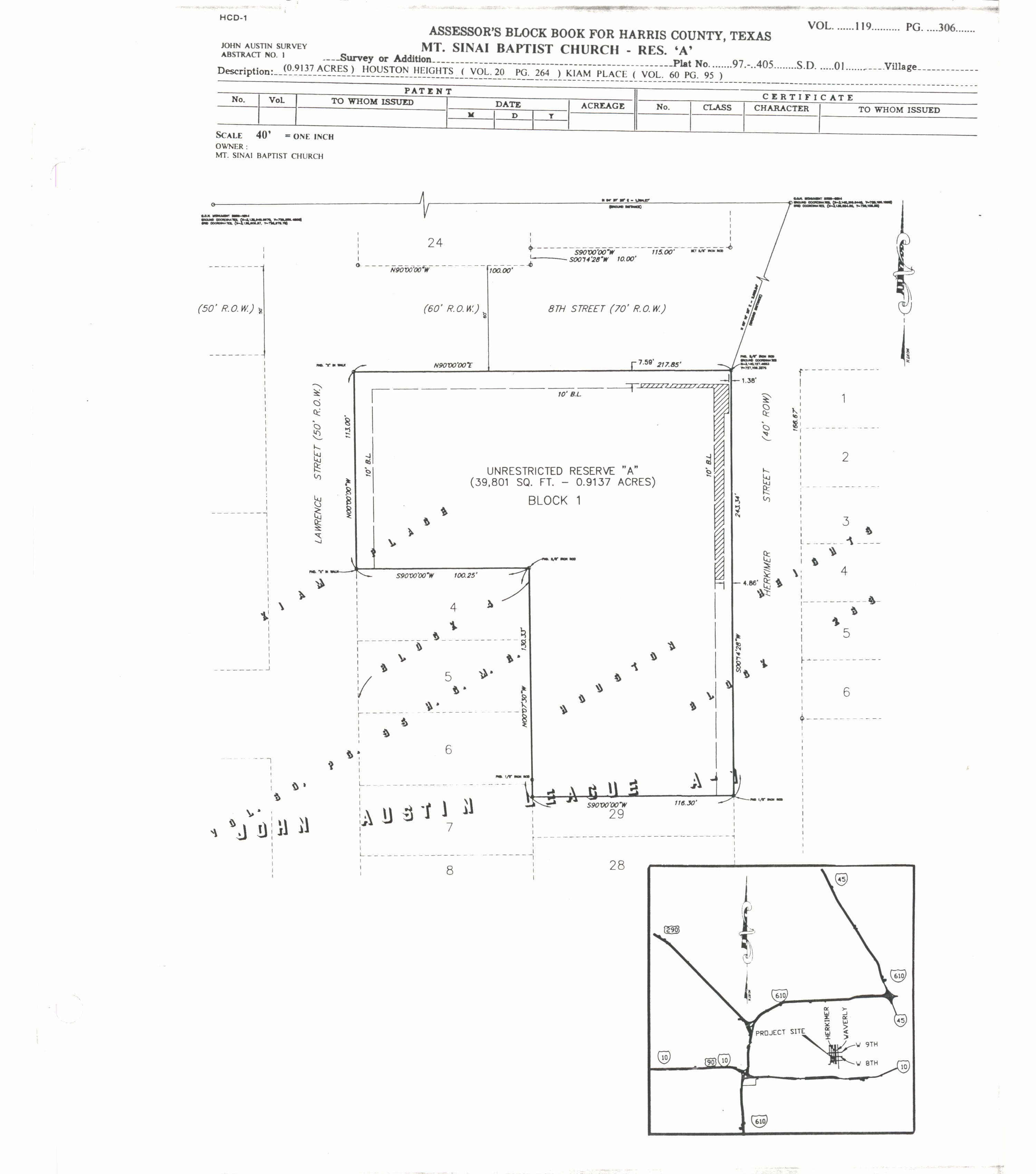
- 268: http://books.tax.hctx.net/v020/AE1997_19-20_0575.jpg and http://books.tax.hctx.net/BlockBooksPDF/v020/AE1997_19-20_0575.PDF - Mt. Sinai Baptist Church Reservation A, Volume 119, Page 306
- Mount Sinai Baptist Church: http://books.tax.hctx.net/BlockBooksPDF/v119/AE1997_119-1_0336.pdf and http://books.tax.hctx.net/v119/AE1997_119-1_0336.jpg
WhisperToMe (talk) 14:27, 8 April 2019 (UTC)
Heights proper part 2[edit]
Continues in Volume 21:
- Index Map for part 2: http://books.tax.hctx.net/BlockBooksPDF/v021/AE1997_21-22_0001.PDF and http://books.tax.hctx.net/v021/AE1997_21-22_0001.jpg - Harper School is outside of the Heights boundary
- 269: http://books.tax.hctx.net/BlockBooksPDF/v021/AE1997_21-22_0002.PDF and http://books.tax.hctx.net/v021/AE1997_21-22_0002.jpg
- 270: http://books.tax.hctx.net/BlockBooksPDF/v021/AE1997_21-22_0003.PDF and http://books.tax.hctx.net/v021/AE1997_21-22_0003.jpg
- 271: http://books.tax.hctx.net/BlockBooksPDF/v021/AE1997_21-22_0004.PDF and http://books.tax.hctx.net/v021/AE1997_21-22_0004.jpg
- 272: http://books.tax.hctx.net/BlockBooksPDF/v021/AE1997_21-22_0005.PDF and http://books.tax.hctx.net/v021/AE1997_21-22_0005.jpg - says see new map
- 272-273: http://books.tax.hctx.net/BlockBooksPDF/v021/AE1997_21-22_0006.PDF and http://books.tax.hctx.net/v021/AE1997_21-22_0006.jpg
- 273: http://books.tax.hctx.net/BlockBooksPDF/v021/AE1997_21-22_0007.PDF and http://books.tax.hctx.net/v021/AE1997_21-22_0007.jpg - says see new map
- 274: http://books.tax.hctx.net/BlockBooksPDF/v021/AE1997_21-22_0008.PDF and http://books.tax.hctx.net/v021/AE1997_21-22_0008.jpg
- 275: http://books.tax.hctx.net/BlockBooksPDF/v021/AE1997_21-22_0009.PDF and http://books.tax.hctx.net/v021/AE1997_21-22_0009.jpg
- 276: http://books.tax.hctx.net/BlockBooksPDF/v021/AE1997_21-22_0010.PDF and http://books.tax.hctx.net/v021/AE1997_21-22_0010.jpg
- 277: http://books.tax.hctx.net/BlockBooksPDF/v021/AE1997_21-22_0011.PDF and http://books.tax.hctx.net/v021/AE1997_21-22_0011.jpg
- 278: http://books.tax.hctx.net/BlockBooksPDF/v021/AE1997_21-22_0012.PDF and http://books.tax.hctx.net/v021/AE1997_21-22_0012.jpg
- 279: http://books.tax.hctx.net/BlockBooksPDF/v021/AE1997_21-22_0013.PDF and http://books.tax.hctx.net/v021/AE1997_21-22_0013.jpg
- 280: http://books.tax.hctx.net/BlockBooksPDF/v021/AE1997_21-22_0014.PDF and http://books.tax.hctx.net/v021/AE1997_21-22_0014.jpg
- 281: http://books.tax.hctx.net/BlockBooksPDF/v021/AE1997_21-22_0015.PDF and http://books.tax.hctx.net/v021/AE1997_21-22_0015.jpg
- 282: http://books.tax.hctx.net/BlockBooksPDF/v021/AE1997_21-22_0016.PDF and http://books.tax.hctx.net/v021/AE1997_21-22_0016.jpg
- 283: http://books.tax.hctx.net/BlockBooksPDF/v021/AE1997_21-22_0017.PDF and http://books.tax.hctx.net/v021/AE1997_21-22_0017.jpg
- 284: http://books.tax.hctx.net/BlockBooksPDF/v021/AE1997_21-22_0018.PDF and http://books.tax.hctx.net/v021/AE1997_21-22_0018.jpg
- 285: http://books.tax.hctx.net/BlockBooksPDF/v021/AE1997_21-22_0019.PDF and http://books.tax.hctx.net/v021/AE1997_21-22_0019.jpg
- 286: http://books.tax.hctx.net/BlockBooksPDF/v021/AE1997_21-22_0020.PDF and http://books.tax.hctx.net/v021/AE1997_21-22_0020.jpg
- 287: http://books.tax.hctx.net/BlockBooksPDF/v021/AE1997_21-22_0021.PDF and http://books.tax.hctx.net/v021/AE1997_21-22_0021.jpg
- 288: http://books.tax.hctx.net/BlockBooksPDF/v021/AE1997_21-22_0022.PDF and http://books.tax.hctx.net/v021/AE1997_21-22_0022.jpg
- 289: http://books.tax.hctx.net/BlockBooksPDF/v021/AE1997_21-22_0023.PDF and http://books.tax.hctx.net/v021/AE1997_21-22_0023.jpg
- 290: http://books.tax.hctx.net/BlockBooksPDF/v021/AE1997_21-22_0024.PDF and http://books.tax.hctx.net/v021/AE1997_21-22_0024.jpg
- 291: http://books.tax.hctx.net/BlockBooksPDF/v021/AE1997_21-22_0025.PDF and http://books.tax.hctx.net/v021/AE1997_21-22_0025.jpg
- 292: http://books.tax.hctx.net/BlockBooksPDF/v021/AE1997_21-22_0026.PDF and http://books.tax.hctx.net/v021/AE1997_21-22_0026.jpg
- 293: http://books.tax.hctx.net/BlockBooksPDF/v021/AE1997_21-22_0027.PDF and http://books.tax.hctx.net/v021/AE1997_21-22_0027.jpg
- 294: http://books.tax.hctx.net/BlockBooksPDF/v021/AE1997_21-22_0028.PDF and http://books.tax.hctx.net/v021/AE1997_21-22_0028.jpg - Says see new map
- 294-295 (new map): http://books.tax.hctx.net/BlockBooksPDF/v021/AE1997_21-22_0029.PDF and http://books.tax.hctx.net/v021/AE1997_21-22_0029.jpg
- 295: http://books.tax.hctx.net/BlockBooksPDF/v021/AE1997_21-22_0030.PDF and http://books.tax.hctx.net/v021/AE1997_21-22_0030.jpg - says see new map and "to flood control"
- 296: http://books.tax.hctx.net/BlockBooksPDF/v021/AE1997_21-22_0031.PDF and http://books.tax.hctx.net/v021/AE1997_21-22_0031.jpg - to HCFC / flood control
- 297: http://books.tax.hctx.net/BlockBooksPDF/v021/AE1997_21-22_0032.PDF and http://books.tax.hctx.net/v021/AE1997_21-22_0032.jpg - to flood control
- 298: http://books.tax.hctx.net/BlockBooksPDF/v021/AE1997_21-22_0033.PDF and http://books.tax.hctx.net/v021/AE1997_21-22_0033.jpg
- 299: http://books.tax.hctx.net/BlockBooksPDF/v021/AE1997_21-22_0034.PDF and http://books.tax.hctx.net/v021/AE1997_21-22_0034.jpg - Part marked Block 315 see page 47
- 300: http://books.tax.hctx.net/BlockBooksPDF/v021/AE1997_21-22_0035.PDF and http://books.tax.hctx.net/v021/AE1997_21-22_0035.jpg - Part marked as deed to public street
- 301: http://books.tax.hctx.net/BlockBooksPDF/v021/AE1997_21-22_0036.PDF and http://books.tax.hctx.net/v021/AE1997_21-22_0036.jpg
- 302: http://books.tax.hctx.net/BlockBooksPDF/v021/AE1997_21-22_0037.PDF and http://books.tax.hctx.net/v021/AE1997_21-22_0037.jpg
- 303: http://books.tax.hctx.net/BlockBooksPDF/v021/AE1997_21-22_0038.PDF and http://books.tax.hctx.net/v021/AE1997_21-22_0038.jpg - Antebellum Homes, Volume 119, Page 547
- 304: http://books.tax.hctx.net/BlockBooksPDF/v021/AE1997_21-22_0039.PDF and http://books.tax.hctx.net/v021/AE1997_21-22_0039.jpg
- 305: http://books.tax.hctx.net/BlockBooksPDF/v021/AE1997_21-22_0040.PDF and http://books.tax.hctx.net/v021/AE1997_21-22_0040.jpg
- 306: http://books.tax.hctx.net/BlockBooksPDF/v021/AE1997_21-22_0041.PDF and http://books.tax.hctx.net/v021/AE1997_21-22_0041.jpg
- 307: http://books.tax.hctx.net/BlockBooksPDF/v021/AE1997_21-22_0042.PDF and http://books.tax.hctx.net/v021/AE1997_21-22_0042.jpg
- 308: http://books.tax.hctx.net/BlockBooksPDF/v021/AE1997_21-22_0043.PDF and http://books.tax.hctx.net/v021/AE1997_21-22_0043.jpg - Mentions Forest Park Block B
- 309: http://books.tax.hctx.net/BlockBooksPDF/v021/AE1997_21-22_0044.PDF and http://books.tax.hctx.net/v021/AE1997_21-22_0044.jpg - part to state
- 310: http://books.tax.hctx.net/BlockBooksPDF/v021/AE1997_21-22_0045.PDF and http://books.tax.hctx.net/v021/AE1997_21-22_0045.jpg - Pumping plant and to state
- 311: http://books.tax.hctx.net/BlockBooksPDF/v021/AE1997_21-22_0046.PDF and http://books.tax.hctx.net/v021/AE1997_21-22_0046.jpg - To state and carried w block 319
- 312: http://books.tax.hctx.net/BlockBooksPDF/v021/AE1997_21-22_0047.PDF and http://books.tax.hctx.net/v021/AE1997_21-22_0047.jpg - To state
- 313: http://books.tax.hctx.net/BlockBooksPDF/v021/AE1997_21-22_0048.PDF and http://books.tax.hctx.net/v021/AE1997_21-22_0048.jpg - To state and to city roadway
- 314: http://books.tax.hctx.net/BlockBooksPDF/v021/AE1997_21-22_0049.PDF and http://books.tax.hctx.net/v021/AE1997_21-22_0049.jpg - To Harris County flood authorities
- 315: http://books.tax.hctx.net/BlockBooksPDF/v021/AE1997_21-22_0050.PDF and http://books.tax.hctx.net/v021/AE1997_21-22_0050.jpg - Flood control
- 315 Abstract 1: http://books.tax.hctx.net/BlockBooksPDF/v021/AE1997_21-22_0051.PDF and http://books.tax.hctx.net/v021/AE1997_21-22_0051.jpg - to flood control district
- 316: http://books.tax.hctx.net/BlockBooksPDF/v021/AE1997_21-22_0052.PDF and http://books.tax.hctx.net/v021/AE1997_21-22_0052.jpg - Parts to Harris County Flood control District
- 317: http://books.tax.hctx.net/BlockBooksPDF/v021/AE1997_21-22_0053.PDF and http://books.tax.hctx.net/v021/AE1997_21-22_0053.jpg - to HCFC
- 318: http://books.tax.hctx.net/BlockBooksPDF/v021/AE1997_21-22_0054.PDF and http://books.tax.hctx.net/v021/AE1997_21-22_0054.jpg - carried w block 319 for 1934
- 319: http://books.tax.hctx.net/BlockBooksPDF/v021/AE1997_21-22_0055.PDF and http://books.tax.hctx.net/v021/AE1997_21-22_0055.jpg
- 320: http://books.tax.hctx.net/BlockBooksPDF/v021/AE1997_21-22_0056.PDF and http://books.tax.hctx.net/v021/AE1997_21-22_0056.jpg - One part marked as Block 310 page 42
- 321: http://books.tax.hctx.net/BlockBooksPDF/v021/AE1997_21-22_0057.PDF and http://books.tax.hctx.net/v021/AE1997_21-22_0057.jpg - To flood control, and see block 309
- 322: http://books.tax.hctx.net/BlockBooksPDF/v021/AE1997_21-22_0058.PDF and http://books.tax.hctx.net/v021/AE1997_21-22_0058.jpg - To HCFC, to city, and block 318 marked
- 323: http://books.tax.hctx.net/BlockBooksPDF/v021/AE1997_21-22_0059.PDF and http://books.tax.hctx.net/v021/AE1997_21-22_0059.jpg - To city
- 324: http://books.tax.hctx.net/BlockBooksPDF/v021/AE1997_21-22_0060.PDF and http://books.tax.hctx.net/v021/AE1997_21-22_0060.jpg - Says see new plate
- 324 New: http://books.tax.hctx.net/BlockBooksPDF/v021/AE1997_21-22_0061.PDF and http://books.tax.hctx.net/v021/AE1997_21-22_0061.jpg - Volume 105 page 162 DR Nov 10 1897
- 325: http://books.tax.hctx.net/BlockBooksPDF/v021/AE1997_21-22_0062.PDF and http://books.tax.hctx.net/v021/AE1997_21-22_0062.jpg - Miller Est - T & NO RR -- also H.&T.C.R.R. - Also H. Hamilton Est see Volume 40 Page 117
- 326: http://books.tax.hctx.net/BlockBooksPDF/v021/AE1997_21-22_0063.PDF and http://books.tax.hctx.net/v021/AE1997_21-22_0063.jpg
- 327: http://books.tax.hctx.net/BlockBooksPDF/v021/AE1997_21-22_0064.PDF and http://books.tax.hctx.net/v021/AE1997_21-22_0064.jpg - H.&T.C.Ry.
- 328: http://books.tax.hctx.net/BlockBooksPDF/v021/AE1997_21-22_0065.PDF and http://books.tax.hctx.net/v021/AE1997_21-22_0065.jpg - H.&T.C.Ry - part to county
- 329: http://books.tax.hctx.net/BlockBooksPDF/v021/AE1997_21-22_0066.PDF and http://books.tax.hctx.net/v021/AE1997_21-22_0066.jpg
- 330: http://books.tax.hctx.net/BlockBooksPDF/v021/AE1997_21-22_0067.PDF and http://books.tax.hctx.net/v021/AE1997_21-22_0067.jpg
- 331: http://books.tax.hctx.net/BlockBooksPDF/v021/AE1997_21-22_0068.PDF and http://books.tax.hctx.net/v021/AE1997_21-22_0068.jpg
- 332: http://books.tax.hctx.net/BlockBooksPDF/v021/AE1997_21-22_0069.PDF and http://books.tax.hctx.net/v021/AE1997_21-22_0069.jpg
- 333: http://books.tax.hctx.net/BlockBooksPDF/v021/AE1997_21-22_0070.PDF and http://books.tax.hctx.net/v021/AE1997_21-22_0070.jpg
- 334: http://books.tax.hctx.net/BlockBooksPDF/v021/AE1997_21-22_0071.PDF and http://books.tax.hctx.net/v021/AE1997_21-22_0071.jpg
(END) WhisperToMe (talk) 14:27, 8 April 2019 (UTC)
Heights Annex[edit]
Heights Annex by lots
- 1-48: http://books.tax.hctx.net/BlockBooksPDF/v039/AE1997_39_0105.pdf and http://books.tax.hctx.net/v039/AE1997_39_0105.jpg
- 49-96: http://books.tax.hctx.net/BlockBooksPDF/v039/AE1997_39_0106.pdf and http://books.tax.hctx.net/v039/AE1997_39_0106.jpg
- 97-144: http://books.tax.hctx.net/BlockBooksPDF/v039/AE1997_39_0107.pdf and http://books.tax.hctx.net/v039/AE1997_39_0107.jpg - Parts to city
- 145-192: http://books.tax.hctx.net/BlockBooksPDF/v039/AE1997_39_0108.pdf and http://books.tax.hctx.net/v039/AE1997_39_0108.jpg
- 289-336: http://books.tax.hctx.net/BlockBooksPDF/v039/AE1997_39_0109.pdf and http://books.tax.hctx.net/v039/AE1997_39_0109.jpg
- 337-384: http://books.tax.hctx.net/BlockBooksPDF/v039/AE1997_39_0110.pdf and http://books.tax.hctx.net/v039/AE1997_39_0110.jpg
- 385-432: http://books.tax.hctx.net/BlockBooksPDF/v039/AE1997_39_0111.pdf and http://books.tax.hctx.net/v039/AE1997_39_0111.jpg - part marked "does not exist"
- 433-482: http://books.tax.hctx.net/BlockBooksPDF/v039/AE1997_39_0112.pdf and http://books.tax.hctx.net/v039/AE1997_39_0112.jpg
- 483-532: http://books.tax.hctx.net/BlockBooksPDF/v039/AE1997_39_0113.pdf and http://books.tax.hctx.net/v039/AE1997_39_0113.jpg
- 533-582: http://books.tax.hctx.net/BlockBooksPDF/v039/AE1997_39_0114.pdf and http://books.tax.hctx.net/v039/AE1997_39_0114.jpg
- 583-632: http://books.tax.hctx.net/BlockBooksPDF/v039/AE1997_39_0115.pdf and http://books.tax.hctx.net/v039/AE1997_39_0115.jpg
- 633-682: http://books.tax.hctx.net/BlockBooksPDF/v039/AE1997_39_0116.pdf and http://books.tax.hctx.net/v039/AE1997_39_0116.jpg
- 683-732: http://books.tax.hctx.net/BlockBooksPDF/v039/AE1997_39_0117.pdf and http://books.tax.hctx.net/v039/AE1997_39_0117.jpg
- 733-782: http://books.tax.hctx.net/BlockBooksPDF/v039/AE1997_39_0118.pdf and http://books.tax.hctx.net/v039/AE1997_39_0118.jpg
- 783-832: http://books.tax.hctx.net/BlockBooksPDF/v039/AE1997_39_0119.pdf and http://books.tax.hctx.net/v039/AE1997_39_0119.jpg
- 833-882: http://books.tax.hctx.net/BlockBooksPDF/v039/AE1997_39_0120.pdf and http://books.tax.hctx.net/v039/AE1997_39_0120.jpg
- 883-932: http://books.tax.hctx.net/BlockBooksPDF/v039/AE1997_39_0121.pdf and http://books.tax.hctx.net/v039/AE1997_39_0121.jpg
- 935-982: http://books.tax.hctx.net/BlockBooksPDF/v039/AE1997_39_0122.pdf and http://books.tax.hctx.net/v039/AE1997_39_0122.jpg
- 983-1032: http://books.tax.hctx.net/BlockBooksPDF/v039/AE1997_39_0123.pdf and http://books.tax.hctx.net/v039/AE1997_39_0123.jpg - parts to city
- 1033-1082: http://books.tax.hctx.net/BlockBooksPDF/v039/AE1997_39_0124.pdf and http://books.tax.hctx.net/v039/AE1997_39_0124.jpg
- 1083-1132: http://books.tax.hctx.net/BlockBooksPDF/v039/AE1997_39_0125.pdf and http://books.tax.hctx.net/v039/AE1997_39_0125.jpg
- 1133-1182: http://books.tax.hctx.net/BlockBooksPDF/v039/AE1997_39_0126.pdf and http://books.tax.hctx.net/v039/AE1997_39_0126.jpg
- 1183-1232: http://books.tax.hctx.net/BlockBooksPDF/v039/AE1997_39_0127.pdf and http://books.tax.hctx.net/v039/AE1997_39_0127.jpg
- 1283-1332: http://books.tax.hctx.net/BlockBooksPDF/v039/AE1997_39_0128.pdf and http://books.tax.hctx.net/v039/AE1997_39_0128.jpg
WhisperToMe (talk) 17:06, 10 April 2019 (UTC)
Others[edit]
Some are indicated on this index map
Bradshaw:
Costick:
Idylwild:
- Lot 63 http://books.tax.hctx.net/v021/AE1997_21-22_0072.jpg and http://books.tax.hctx.net/BlockBooksPDF/v021/AE1997_21-22_0072.PDF
Kiam:
Kutchback:
Milroy Place:
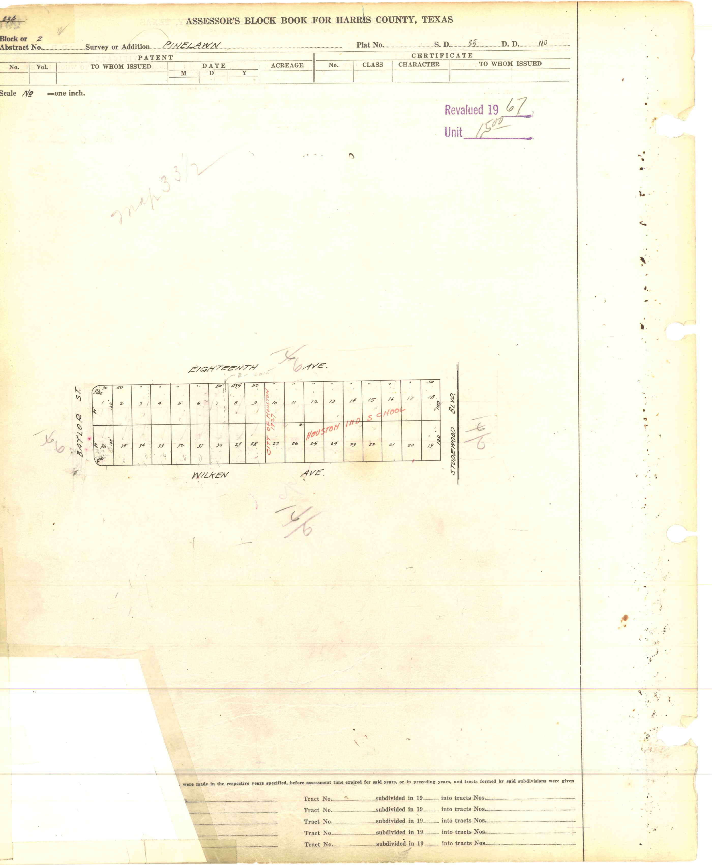
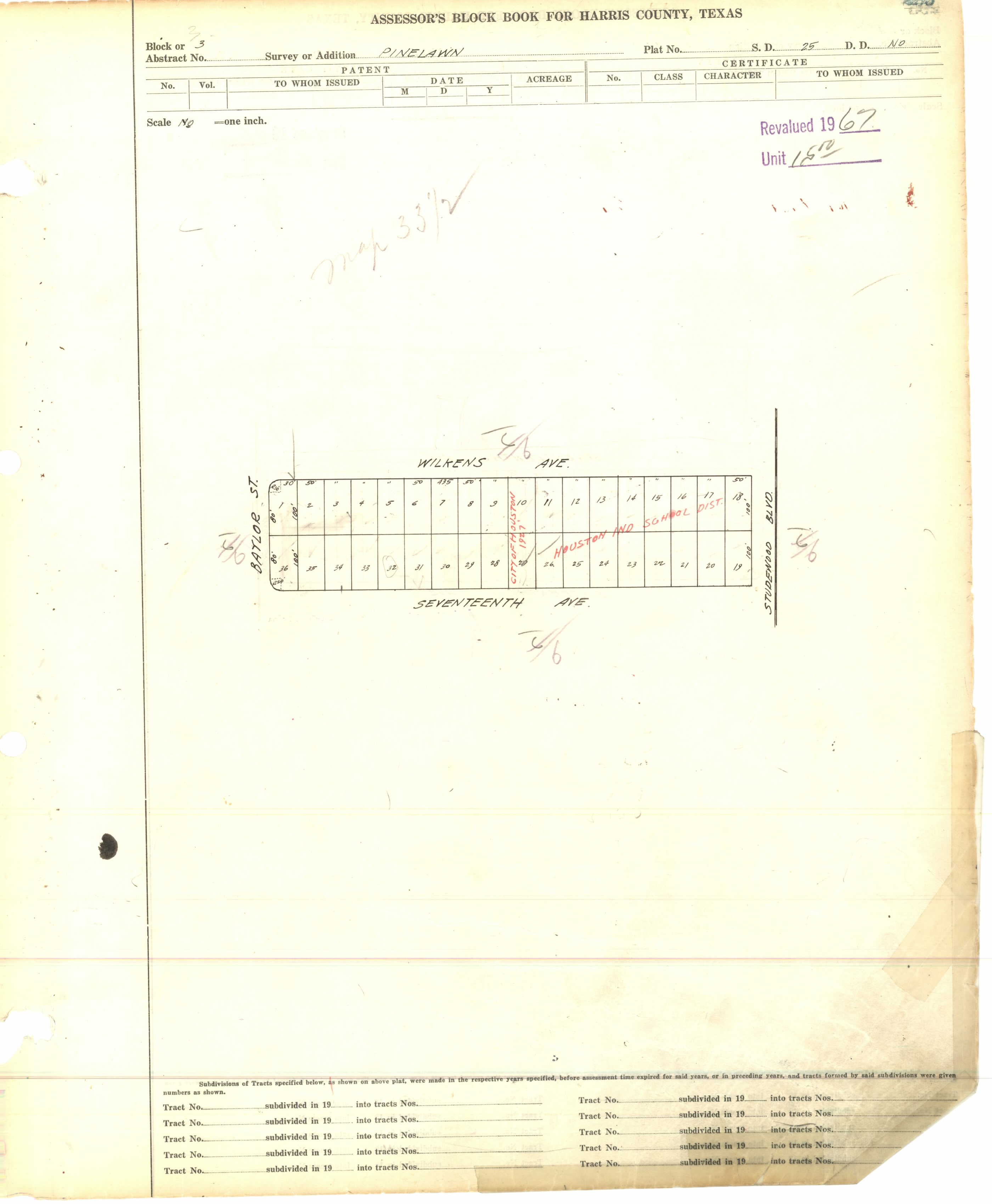
Pinelawn (listed as "Pine Lawn")
- 1: http://books.tax.hctx.net/BlockBooksPDF/v054/AE1997_54_0275.pdf and http://books.tax.hctx.net/v054/AE1997_54_0275.jpg - Sheldon Street marked
- 2: http://books.tax.hctx.net/BlockBooksPDF/v054/AE1997_54_0276.pdf and http://books.tax.hctx.net/v054/AE1997_54_0276.jpg - Marked as city of Houston and "Houston Ind School" - This would be the northern half of the grounds of Eugene Field Elementary School
- 3: http://books.tax.hctx.net/BlockBooksPDF/v054/AE1997_54_0277.pdf and http://books.tax.hctx.net/v054/AE1997_54_0277.jpg - Marked as city of Houston and "Houston Ind School" - This would be the southern half of the grounds of Eugene Field Elementary School
- 4: http://books.tax.hctx.net/BlockBooksPDF/v054/AE1997_54_0278.pdf and http://books.tax.hctx.net/v054/AE1997_54_0278.jpg
- 5: http://books.tax.hctx.net/BlockBooksPDF/v054/AE1997_54_0279.pdf and http://books.tax.hctx.net/v054/AE1997_54_0279.jpg
- 6: http://books.tax.hctx.net/BlockBooksPDF/v054/AE1997_54_0280.pdf and http://books.tax.hctx.net/v054/AE1997_54_0280.jpg
- 7: http://books.tax.hctx.net/BlockBooksPDF/v054/AE1997_54_0281.pdf and http://books.tax.hctx.net/v054/AE1997_54_0281.jpg
Ridgewood:
Shadywood:
West Heights by block:
- 1-4: http://books.tax.hctx.net/BlockBooksPDF/v060/AE1997_Vol_60_0078.pdf and http://books.tax.hctx.net/v060/AE1997_Vol_60_0078.jpg
- 5-8: http://books.tax.hctx.net/BlockBooksPDF/v060/AE1997_Vol_60_0079.pdf and http://books.tax.hctx.net/v060/AE1997_Vol_60_0079.jpg
- 9-12: http://books.tax.hctx.net/BlockBooksPDF/v060/AE1997_Vol_60_0080.pdf and http://books.tax.hctx.net/v060/AE1997_Vol_60_0080.jpg - resubmitted in red
WhisperToMe (talk) 16:27, 10 April 2019 (UTC)