
Vrouwenpolder
Vrouwenpolder | |
|---|---|
Village | |
 Church: de Pelgrimskerk | |
 Coat of arms | |
 Vrouwenpolder Location in the province of Zeeland in the Netherlands  Vrouwenpolder Vrouwenpolder (Netherlands) | |
| Coordinates: 51°34′34″N 3°36′55″E / 51.57611°N 3.61528°E | |
| Country | Netherlands |
| Province | Zeeland |
| Municipality | Veere |
| Area | |
| • Total | 13.28 km2 (5.13 sq mi) |
| Elevation | 2.1 m (6.9 ft) |
| Population (2021)[1] | |
| • Total | 1,015 |
| • Density | 76/km2 (200/sq mi) |
| Time zone | UTC+1 (CET) |
| • Summer (DST) | UTC+2 (CEST) |
| Postal code | 4354[1] |
| Dialing code | 0118 |
Vrouwenpolder is a village in the Dutch province of Zeeland. It is a part of the municipality of Veere, and lies about 9 km north of Middelburg. The name is derived from "the polder of Our Lady", referring to the Virgin Mary.
History[edit]
The village was first mentioned in 1338 as "up die polre", and is a reference to the eponymous polder which was created in 1299. Vrouwen is a reference to Mary, mother of Jesus for whom was a chapel built in the village shortly after 1314.[3]
The chapel was elevated to parish church in 1324, and became a site of pilgrimage in the 14th century due to presence of a miraculous painting. The medieval church was destroyed in 1572 during the Dutch Revolt, and rebuilt in 1624 as a single aisled Dutch Reformed church with a ridge turret.[4][5]
In 1588, Fort den Haak was built to protect the Veerse Gat. In 1809, the English attacked and conquered the fort, however they were unable to make progress and left again.[5] Vrouwenpolder was home to 385 people in 1840.[6]
During the Battle of the Scheldt the land was inundated and Vrouwenpolder was damaged by bombing. 8 November 1944, coastal battery W19 near Vrouwenpolder, the last German stronghold surrendered.[5]
Vrouwenpolder was a separate municipality until 1966, when it was merged with Veere. Its formal long name was 'Onze-Lieve-Vrouwenpolder, Schellach en Zanddijk-Buiten'. The former municipality of Gapinge was added to O.L.Vrouwenpolder in 1857.[7]
Beach[edit]
In 1930, the first recreational houses were built in the dunes near the village.[4] The bungalow park Breezand was extended in the 1960 with hotels and shops and transformed in a seaside resort.[6]
Between the dunes and village, Oranjezon is located, a 400 hectares (990 acres) nature area.[5]
There is a nudist beach at Vrouwenpolder.[8]
Gallery[edit]
-
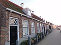
 Street view
 -
 Oranjezon nature area
 -
 Street view
 -
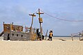 Beach of Vrouwenpolder

_(12).jpg)


References[edit]
- ^ a b c "Kerncijfers wijken en buurten 2021". Central Bureau of Statistics. Retrieved 23 April 2022.
two entries
- ^ "Postcodetool for 4354AA". Actueel Hoogtebestand Nederland (in Dutch). Het Waterschapshuis. Retrieved 23 April 2022.
- ^ "Vrouwenpolder - (geografische naam)". Etymologiebank (in Dutch). Retrieved 23 April 2022.
- ^ a b Piet van Cruyningen & Ronald Stenvert (2003). Vrouwenpolder (in Dutch). Zwolle: Waanders. ISBN 90 400 8830 6. Retrieved 23 April 2022.
- ^ a b c d "Vrouwenpolder". Zalig Zeeland (in Dutch). Retrieved 23 April 2022.
- ^ a b "Vrouwenpolder". Plaatsengids (in Dutch). Retrieved 23 April 2022.
- ^ Ad van der Meer and Onno Boonstra, Repertorium van Nederlandse gemeenten, KNAW, 2011.
- ^ "Nudist beach Vrouwenpolder". naaktstrandje.nl. Retrieved 2016-03-06.
External links[edit]
 Media related to Vrouwenpolder at Wikimedia Commons
| International | |
|---|---|
| National | |