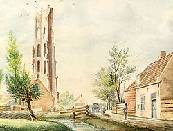
Zanddijk
Zanddijk | |
|---|---|
Neighbourhood and former village | |
 Ruined church tower of Zanddijk (1812) | |
| Coordinates: 51°32′22″N 3°39′30″E / 51.53944°N 3.65833°E | |
| Country | Netherlands |
| Province | Zeeland |
| Municipality | Veere |
| Area | |
| • Total | 0.40 km2 (0.15 sq mi) |
| Elevation | 3.1 m (10.2 ft) |
| Population (2021)[1] | |
| • Total | 855 |
| • Density | 2,100/km2 (5,500/sq mi) |
| Time zone | UTC+1 (CET) |
| • Summer (DST) | UTC+2 (CEST) |
| Postal code | 4351[1] |
| Dialing code | 0118 |
Zanddijk is a neighbourhood of Veere and former village in the municipality of Veere, Zeeland, Netherlands.[3]
History[edit]
The hamlet was probably founded in the first half of the twelfth century when some local farmers went to live on a dike made of sand, for which the hamlet was named.[4] (Zanddijk literally means "sand dike".) By 1153 Zanddijk had become a lordship.[4] In 1247 Hendrik Wisse van Borsele inherited the lordship and had a fort constructed there.[4] Under Van Borsele, Zanddijk grew into a wealthy village.[4] Veere was founded on the lordship's territory and quickly grew into a city, overshadowing Zanddijk itself.[4] In 1347 it split off from the lordship.[4] In 1439 parts of Zanddijk were acquired by Veere and in 1574 the rest were put under its control.[4] During the Beeldenstorm its church was damaged but not destroyed; but soon after, it was destroyed anyway.[4] In 1572 Veere went over to the Dutch and provided troops for the Siege of Vlissingen.[4] During the Eighty Years' War, in 1748 it counted only 416 inhabitants.[4] During the Coalition Wars the French built fortifications around the village.[4] In the 1930s its strategic position again saw Zanddijk the location of a line of fortification.[5][6]
References[edit]
- ^ a b c "Kerncijfers wijken en buurten 2021". Central Bureau of Statistics. Retrieved 22 April 2022.
- ^ "Postcodetool for 4351AA". Actueel Hoogtebestand Nederland (in Dutch). Het Waterschapshuis. Retrieved 22 April 2022.
- ^ "Veere". Plaatsengids (in Dutch). Retrieved 22 April 2022.
- ^ a b c d e f g h i j k "Thema: Het oude Zanddijk". www.stichtingveere.nl. Retrieved 2020-04-13.
- ^ Nationaal Comité 4 em 5 mei & Noordhoff Atlasproducties. De Bosatlas van de Tweede Wereldoorlog. 75 Jaar Vrijheid, Vfonds, Rijksoverheid, Nationale Postcode Loterij. p. 36.
{{cite book}}: CS1 maint: numeric names: authors list (link) - ^ "Zanddijk, Zuid-Beveland, Zeeland | Bunkersite.com". bunkersite.com. Retrieved 2020-04-13.


