
Belle Isle Northeast Light
This article includes a list of general references, but it lacks sufficient corresponding inline citations. (April 2013) |
 | |
| Location | Belle Isle between Newfoundland and Labrador Canada |
|---|---|
| Coordinates | 52°00′50.2″N 55°16′50.2″W / 52.013944°N 55.280611°W |
| Tower | |
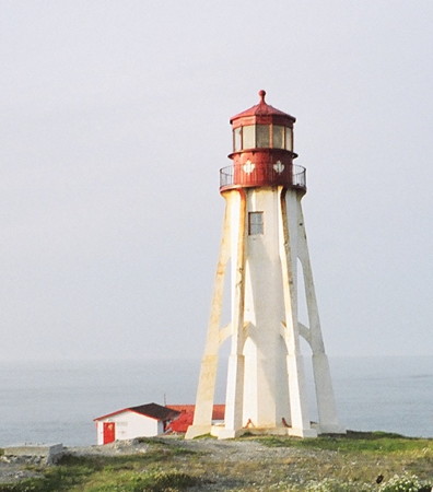
| Constructed | 1905 |
| Construction | concrete tower |
| Height | 27 metres (89 ft) |
| Shape | dodecagonal tower with six flying buttress |
| Markings | white tower, red lantern |
| Power source | solar power |
| Operator | Canadian Coast Guard[1] |
| Heritage | recognized federal heritage building of Canada |
| Fog signal | Horn(1) 30s |
| Light | |
| Focal height | 42 metres (138 ft) |
| Range | 17 nmi (31 km; 20 mi) |
| Characteristic | Fl W 11s. |
Belle Isle Northeast Light is a 27-metre (89 ft) tall, 12-sided flying buttress lighthouse located on Belle Isle, Newfoundland, which was built in 1905. It is one of three lighthouses on the island and was maintained by the Canadian Government despite the fact that Newfoundland did not join Confederation until 1949. It was designed by William P. Anderson as one in a series of nine buttressed lighthouses built in Canada around 1910.[2]
Its light characteristic is a white flash occurring every eleven seconds. The lightsource is placed at a focal plane of 42 metres (138 ft) above sea level. A fog signal consisting of a single blast may be sounded every 30 seconds if needed.
See also[edit]
References[edit]
- ^ Rowlett, Russ. "Lighthouses of Canada: Labrador and Belle Isle". The Lighthouse Directory. University of North Carolina at Chapel Hill. Retrieved December 29, 2015.
- ^ Rowlett, Russ. "Canadian Flying Buttress Lighthouses". The Lighthouse Directory. University of North Carolina at Chapel Hill.
External links[edit]
- Picture of Belle Isle Northeast Lighthouse
- Aids to Navigation Canadian Coast Guard
| Authority control databases: Geographic |
|---|
This Newfoundland and Labrador lighthouse-related article is a stub. You can help Wikipedia by expanding it. |