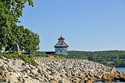
Fort Point Lighthouse (Nova Scotia)
 Fort Point Lighthouse in 2011 | |
 | |
| Location | LaHave Nova Scotia Canada |
|---|---|
| Coordinates | 44°02′39″N 64°42′28″W / 44.04406°N 64.70765°W |
| Tower | |
| Constructed | 1855 |
| Construction | wooden tower and lantern |
| Height | 9 metres (30 ft) |
| Shape | square tower with balcony and lantern atop a 2-storey keeper’s house |
| Markings | white tower, red trim and lantern roof |
| Operator | Region of Queens Municipality[1][2] |
| Heritage | provincially registered property |
| Light | |
| Deactivated | 1989 |
Fort Point Lighthouse is a lighthouse located on the Mersey River outside the town of Liverpool in the Canadian province of Nova Scotia. First erected in 1832, it served as a navigational aid for local sailors and fishermen until 1954, when it was taken out of operation.[3]
See also[edit]
References[edit]
- ^ Rowlett, Russ. "Lighthouses of Canada: Southern Nova Scotia". The Lighthouse Directory. University of North Carolina at Chapel Hill. Retrieved 2017-02-25.
- ^ Fort Point, NS Lighthouse Friends. Retrieved 25 February 2017
- ^ "Fort Point (LaHave River)". www.nslps.com. Archived from the original on 2016-09-13. Retrieved 2016-08-31.
External links[edit]
- Region of Queens Municipality Retrieved 25 February 2017
- Fort Point Lighthouse Canada's Historic Places. Retrieved 25 February 2017
- Aids to Navigation Canadian Coast Guard
Wikimedia Commons has media related to Fort Point Lighthouse.

