
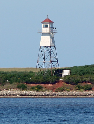
Malpeque Harbour Approach Range Lights
 | |
| Location | Hog Island Prince Edward Island Canada |
|---|---|
| Coordinates | 46°34′40″N 63°43′11″W / 46.577805°N 63.719740°W |
| Tower | |
| Constructed | 1961 |
| Construction | steel skeletal tower and wooden upper covered section |
| Height | 15.2 metres (50 ft) |
| Shape | square tower with balcony and lantern |
| Markings | red skeletal tower, white upper section |
| Operator | Canadian Coast Guard[2] |
| Light | |
| First lit | 1961 |
| Deactivated | 2011 |
| Focal height | 16.8 metres (55 ft) |
| Range | 10 nautical miles (19 km; 12 mi)[1] |
| Characteristic | Iso W 4s |
The Malpeque Harbour Approach Range Lights are a set of range lights on Prince Edward Island, Canada. The current rear tower was built in 1961.[3]
See also[edit]
References[edit]
- ^ Lighthouses of Prince Edward Island
- ^ Rowlett, Russ. "Lighthouses of Canada: Western Prince Edward Island". The Lighthouse Directory. University of North Carolina at Chapel Hill. Retrieved January 9, 2016.
- ^ Rowlett, Russ. "Lighthouses of Canada: Eastern Prince Edward Island". The Lighthouse Directory. University of North Carolina at Chapel Hill. Retrieved August 2, 2009.
External links[edit]
- Picture of Malpeque Harbour Approach Range Rear Light Lightouse Friends
- Aids to Navigation Canadian Coast Guard
This Prince Edward Island lighthouse-related article is a stub. You can help Wikipedia by expanding it. |