
Murray Harbour Range Lights
 | |
| Location | Beach Point Prince Edward Island Canada |
|---|---|
| Coordinates | 46°01′N 62°29′W / 46.01°N 62.49°W |
| Tower | |
| Constructed | 1869 |
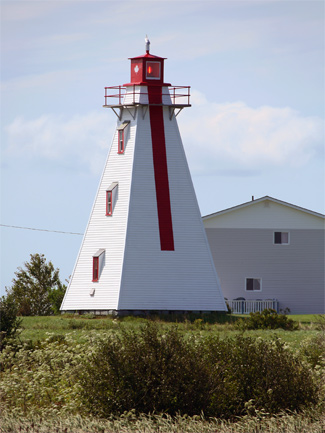
| Murray Harbour Back Range Light | |
.jpg) | |
| Constructed | 1869 (first) |
| Construction | wooden tower |
| Height | 13 m (43 ft) |
| Shape | square tower with balcony and lantern[1][2] |
| Markings | white tower with a red vertical range line, red lantern |
| Operator | Canadian Coast Guard |
| Heritage | Registered Heritage Place |
| First lit | 1879 (current) |
| Focal height | 17 m (56 ft) |
| Range | 10 nmi (19 km; 12 mi) |
| Characteristic | F R |
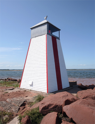
| Murray Harbour Front Range Light | |
.jpg) | |
| Constructed | 1869 (first) |
| Construction | wooden tower |
| Height | 7 m (23 ft) |
| Shape | square tower with lantern |
| Markings | white tower with a red vertical range line, red trim |
| Operator | Canadian Coast Guard |
| Heritage | Registered Heritage Place |
| First lit | 1879 (current) |
| Deactivated | 2010-2011 |
| Focal height | 6 m (20 ft) |
| Range | 10 nmi (19 km; 12 mi) |
| Characteristic | F R |
The Murray Harbour Range Lights are a set of range lights near Murray Harbour, Prince Edward Island, Canada. They were built in 1879, and are still active.[3]
See also[edit]
References[edit]
- ^ Rowlett, Russ. "Lighthouses of Canada: Eastern Prince Edward Island". The Lighthouse Directory. University of North Carolina at Chapel Hill. Retrieved January 9, 2016.
- ^ "Prince Edward Island Lighthouse Society". www.peilighthousesociety.ca. Archived from the original on 2016-03-16. Retrieved 2016-01-09.
- ^ Rowlett, Russ. "Lighthouses of Canada: Eastern Prince Edward Island". The Lighthouse Directory. University of North Carolina at Chapel Hill. Retrieved August 2, 2009.
External links[edit]
- Picture of Murray Harbour Range Rear Light
- Picture of Murray Harbour Range Front Light
- Aids to Navigation Canadian Coast Guard
| Murray Harbour Back Range Light | |
|---|---|
| Murray Harbour Front Range Light | |
This Prince Edward Island lighthouse-related article is a stub. You can help Wikipedia by expanding it. |